Acklam Road, W10

Road in/near Notting Hill, existing between 1866 and now.

 HOME  ·  ARTICLE  ·  MAPS  ·  STREETS  ·  BLOG  ·  CONTACT US 
(51.5204 -0.2051, 51.52 -0.205) 
MAP YEAR:175018001810182018301860190019502024Show map without markers
TIP: To create your own sharable map, right click on the map
 
Road · * · W10 ·
MAY
11
2020
Acklam Road was the centre of much action during the building of the Westway.

When the Portobello farmhouse featured in a watercolour in 1864, shortly before its demise, the only other building on the lane north of the newly opened Hammersmith and City railway line was the Notting Barn Lodge, situated on Portobello Lane at the future junction of Cambridge Gardens. This lodge stood by the entrance to the lane leading to the other farm of the same name, to the west.

Florence Gladstone wrote in ‘Notting Hill in Bygone Days’: ‘There seems to be a natural break where the railway embankment crosses Portobello Road. At this point the old lane was interrupted by low marshy ground, overgrown with rushes and watercress.’ But within a few years of the painting the last remaining fields of Portobello farm would become the streets of the Golborne ward.

Alongside the railway line boundary of the Golborne and Colville wards, Acklam Road was built in the late 1860s and stood for a hundred years, before being demolished to make way for the Westway flyover in the late 1960s.

The road took its name from the Acklam village, now in Middlesborough, which like Rillington and Ruston is close to the Yorkshire country seat of the North Kensington developer Colonel St Quintin. The old street featured the Duke of Sussex pub on the corner of Portobello Road, currently an open-air market area by the entrance to the Acklam Village farmers; market. Acklam Road was built under the direction of the Land and House Investment Society Ltd.

At the beginning of the 20th century, on Charles Booth’s ‘Life and Labour of the People of London’ map, conditions on Acklam Road were assessed as fairly comfortable with some poverty and comfort mixed on the Portobello corner.

In the 1914 street directory, the south side was occupied by Jane Wood’s laundry at number 2, the coal dealer John Richards at 18, John Getgood & Son’s loan office at 52, the greengrocer Henry Day and general dealer Albert Moore at 106, the bootmaker Albert Apps at 108 and the newsvendor Henry Temperton at 110. On the north side there was the timber merchant William Wilkins at number 1, Harrison & Co builders at 17, the French polisher John Hobbs at 29, who was still going in the 1930s, the bricklayer George Reeve at 43, Rose Heffernan’s chandler’s shop at 51, the confectioner Alfred Bradley at 63, the beer retailer Florence Mulberry at 65 and tobacconist Emma James at 77.


Portobello farmhouse, 1864


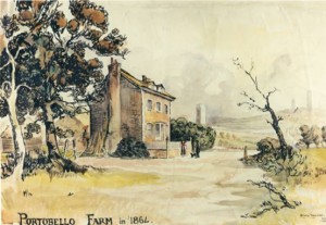
Portobello farmhouse, 1864
(click image to enlarge)


By 1935 number 1 had become J Sandell & Co timber merchants and remained so into the 60s, William Croft was running the chandler’s shop at 51, Robert Broom was the beer retailer at 65, accompanied by the boot repairer George Hawkes, 77 was George England’s confectioner’s shop, 110 was Ernest Butcher’s newsagents till the 60s, and 114 by the railway footbridge was the Pembroke Athletic Club boxing gym. In the 60s the scrap metal merchants Acklam Metals were established at number 20 on the south side, 51 was David James & Son grocery shop and the beer retailer at 65 was Kenneth Stokes.
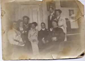
From the 19th century up until 1965, number 3 Acklam Road, near the Portobello junction, was occupied by the Bedford family. When the Westway construction work began they sold up and moved to south London. Anne Bedford (now McSweeney) is pictured in the 60s standing outside the house with her back to the south side of the street, shortly before it was demolished, behind which was the tube line. Her grandparents were photographed on their wedding day in 1910 in the top floor front room, next to their piano. In the early 70s the house was taken over by the North Kensington Amenity Trust and became the Notting Hill Carnival office before its eventual demolition.

Anne McSweeney: ‘My memories are all happy from living there. I now know that the conditions were far from ideal but then I knew no different. There was no running hot water, inside toilet or bath, apart from the tin bath we used once a week in the large kitchen/dining room. Any hot water needed was heated in a kettle. I wasn't aware that there were people not far away who were a lot worse off than us, living in poverty in houses just like mine but families renting one room. We did have a toilet/bathroom installed in 1959, which was ‘luxury’. My grandparents and uncle lived on the top floor, and mum, dad and I lived below them with a bedroom at the front at street door level, which my uncle used. The room at street level to the rear was used by my father as a workshop and later became the bathroom.


Duke of Sussex pub, from a postcard


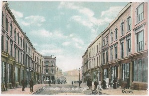
Duke of Sussex pub, from a postcard
(click image to enlarge)


‘When the plans for the Westway were coming to light, we were still living in the house whilst all the houses opposite became empty and boarded up one by one. We watched all this going on and decided that it was not going to be a good place to be once the builders moved in to demolish all the houses and start work on the elevated road. Dad sold the house for a fraction of what it should have been worth but it needed too much doing to it to bring it to a good living standard. We were not rich by any means but we were not poor. My grandmother used to do her washing in the basement once a week by lighting a fire in a big concrete copper to heat the water, which would have been there until demolition. There was also a huge wood and metal mangle with wooden rollers to wring out the wet clothes by turning the handle.

For the first 12 years of my life, going to the loo would have meant several flights of stairs to the basement and outside into the yard, not too good, especially in winter. We were the only house not to have a garden as we were beside the timber yard, whose yard sloped and therefore tapered the size of the rear of the house so we only had a very small yard, but we did have the biggest house in the street as we had the extra rooms over the timber yard entrance. Coal being delivered is another memory for me, as the coalman would come round with sacks on his cart and open the manhole cover on the pavement and whoosh the coal into the cellar below. As a child I would be asked to go to the basement to fill a bucket with coal for use upstairs and I remember that I would frighten myself thinking that there could be someone or something lurking in the shadows – all quite dimly lit down there so I used to sing or make noise as I got to the basement and opened the coal cellar door.


The Bedford family, photographed in 1910.


The Bedford family, photographed in 1910.
(click image to enlarge)


‘When we moved from number 3, I remember the upright piano that my grandparents used to play – and me of sorts – being lowered out of the top floor and taken away, presumably to be sold. I used to play with balls up on the wall of the chemist shop on the corner of Acklam and Portobello. We would mark numbers on the pavement slabs in a grid and play hopscotch. Roller-skating, skipping ropes, scooters and tricycles were other outside activities. I once was swinging on the gate of the basement over the basement steps – we used to call it the airy – and the gate came off and I ended up at the bottom of the steps. Dad took me to the chemist and I remember sitting on a bench while the pharmacist cut away part of my hair to treat a cut on the back of my head. At the Portobello and Acklam Road corner, on one side there was the Duke of Sussex pub, on the other corner, a chemist, later owned by a Mr Fish, which I thought was amusing. When I was very young I remember every evening a man peddling along Acklam Road with a long thin stick with which he lit the streetlights.’

Michelle Active who lived at 33 Acklam Road: ‘I was 6 then and sort of remember the goings on but didn’t really understand. 6 of us lived in a one-bed basement flat on Acklam Road. When they demolished it we moved to a 4-bed maisonette on Silchester Estate and I thought it was a palace, two toilets inside, a separate bathroom that was not in the kitchen, absolute heaven.’

Before Westway construction work began in 1966, the site of the south side of Acklam Road towards Westbourne Park hosted the London Free School adventure playground. This hippy community action project was inaugurated with an auto-destructive art performance by Gustav Metzger, consisting of a pile of rubbish that was set alight by local children. The Westway site was called ‘the dark side of the moon’ by Emily Young (of Pink Floyd’s ‘See Emily Play’ fame) in Jonathon Green’s ‘Days in the Life’ counter-culture oral history book: “They were starting to build the motorway and they’d knocked down this run of houses. It was the dark side of the moon, the other side of wonderful Britain. It was the Martian wasteland. There were dead donkeys lying around, and dead people, a dead baby one time, a very weird place, desolation. And we’d have happenings; huge bonfires and musicians would come and Dave Tomlin played the saxophone and wrote poems and we’d take a lot of acid.”


Outside the Duke of Sussex


Outside the Duke of Sussex
(click image to enlarge)


The Free School adventure playground was founded by Adam Ritchie, a local activist and photographer who had been in New York at the time of community action in Tompkins Square that saved a play area from redevelopment. On the site of the Westway, he recalled ‘complex, wonderful structures’ being created by the local children, after he left out a hammer, saw and nails for them to use. In ‘The Politics of Community Action’ description by Jan O’Malley: ‘Steps were built down from the road to give children access and rough structures and swings were knocked together.’

At the last London Free School project meeting, as construction work began in September 1966, Adam Ritchie proposed continuing the adventure playground part of the project under the flyover. The North Kensington Playspace Group proto-Westway Trust was subsequently formed by him and John O’Malley of the Notting Hill Community Workshop, with the aim of establishing a permanent adventure playground on Acklam Road. At this stage according to Jan O’Malley: ‘No one was certain about the use planned for the motorway space. While the chairman of the GLC Highways Committee had a vague idea that the space was to be used for recreation, the engineers building it believed the plans were to use it for warehousing and a car park.’

Dave Robins wrote in the Notting Hill ‘Interzone’ issue of International Times in May 1968: 'The area could congeal into a genuinely depressed ghetto, people’s social and economic needs being overshadowed by the gigantic inhuman motorway. This is what happened after the building of over-head railways in Chicago and New York. Local politicians could seize this opportunity to turn Notting Hill into Britain’s first US style black ghetto (if it isn’t that already). A lot may depend on the use of the huge arches or spans which carry the motorway… If the spans are given over to the community, the possibilities for further creative extensions to the children’s adventure playground, already under way in Westbourne Park, are total. At the moment, the Council has provisionally accepted the £½ million scheme of amenities, play facilities and open space use of the arches and spans under the Western Avenue Extension put forward by Adam Ritchie, John O’Malley and their North Kensington Playspace Group.’


Acklam playground


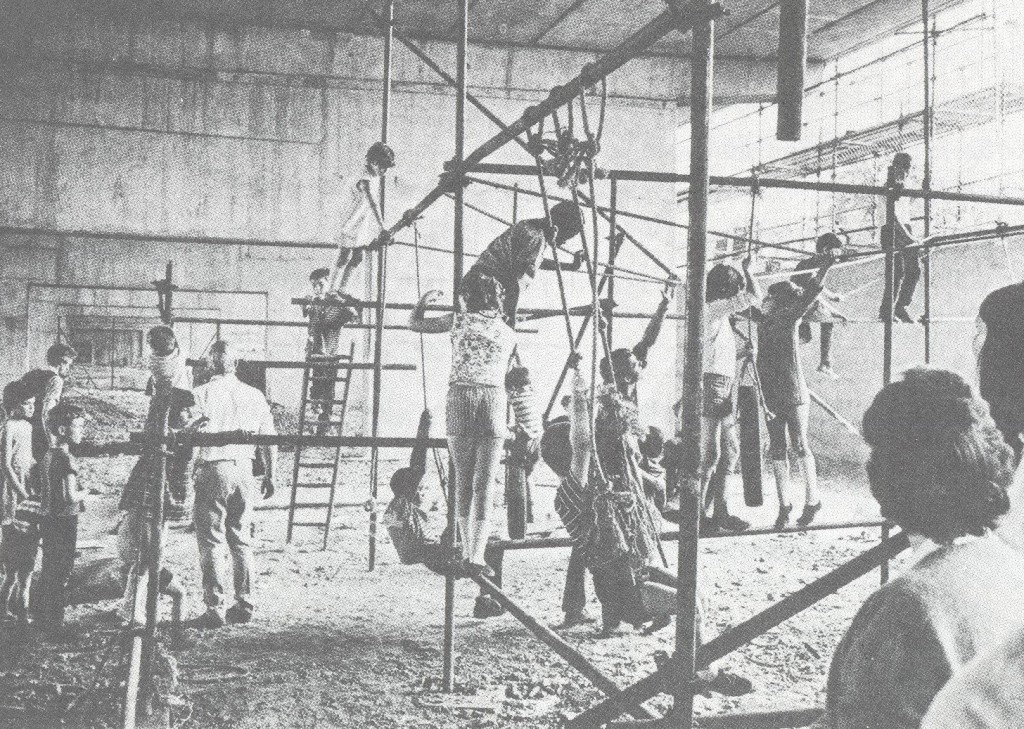
Acklam playground
(click image to enlarge)


As the Playspace Group was renamed the Motorway Development Trust in late 1968, their plan outlined by Robin Moore was to create: “a kind of community strip, a bustling social market place, complementing the commercial activity of Portobello Road.” The proposed amenities for the Acklam Road bays were a public laundry, café, health centre, nursery school, pre-school playgroup, sport area and adventure playground. After the Motorway Development Trust established the first adventure playground under the flyover on St Mark’s Road, with the assistance of the Westway contractors Laing Construction, for the next summer holidays in 1969 the Acklam Road Adventure Playground was opened in 6 bays east of Portobello Road. The following year it was established as a permanent playground with a hut.

Adam Ritchie says of his 1969 Acklam playground photographs displayed on the site in Steve Mepsted’s Orphans mural exhibition: “I was part of a whole lot of people who got these playgrounds going in the first place and got them under the motorway, because it was supposed to be a car park for commuters. So we rigged up scaffolding and there was stuff going on, and the kids made lots of things – constructions. In one of them there’s a huge packing case that we got and the kids were making houses or whatever they were doing out of it. The people in them, the kids are absolutely beautiful, they just look as if they’re free and having a wonderful time.”

During the four years of construction work, for the remaining inhabitants of the north side of Acklam Road and the other surviving terraces close to the flyover, ‘continuous noise and dirt from heavy lorries and machinery became a familiar and unwelcome part of life.’ The sound of the Westway being built was described by Eileen Wright in ‘Taking on the Motorway’: “There was a terrible noise for weeks when they were pile-driving. They started at 6 O’clock in the morning – sometimes it went on all night. You think the whole city is being bombarded beneath you.”

From 1968 through the 70s, the wall alongside the Hammersmith and City line beneath the Westway between Portobello Road and Westbourne Park featured graffiti by the Situationist King Mob group that read: ‘Same thing day after day – Tube – Work – Diner (sic) – Work – Tube – Armchair – TV – Sleep – Tube – Work – How much more can you take – One in ten go mad – One in five cracks up.’


MDT plan
(click image to enlarge)


On July 28 1970 the Westway, A40 Western Avenue Extension flyover between White City and Paddington, at two and half miles, the longest elevated road in Europe at the time, was opened by Michael Heseltine, the parliamentary secretary to the transport minister. The opening ceremony was famously accompanied by a protest over the re-housing of the last residents alongside the road. As demonstrators disrupted the ribbon cutting, a banner was unfurled on Acklam Road, looking on to the flyover, demanding: ‘Get Us Out of this Hell. Re-house Us Now’.

Michael Heseltine told the press: “There are two sides to this business. One is the exciting road building side… but there is also the human side of this thing, and how huge roads like this affect people living alongside them. You cannot but have sympathy for these people.” The Standard reported that: ‘the ministerial cavalcade later drove the length of the twin dual-carriageway running from Paddington to White City. On the way it passed Acklam Road, where bedrooms of houses are less than 50 feet from the elevated section of the road. Here the GLC is proposing to spend £250,000 buying 42 houses which have been ‘blighted’, demolish them and turn the land acquired into a buffer state.’

The Acklam Road residents’ representative George Clark protested to the Transport Minister John Peyton (who said he couldn’t attend the opening because he had to be at a cabinet meeting): “I want to make a statement to the minister about the hell on earth in North Kensington. During the 5 years it has taken to construct this engineering marvel, the lives and social conditions of the residents of Acklam Road and Walmer Road have been made hell upon earth. For these people the new urban highway is a social disaster.”

The Westway opening protest developed into a local dispute between Walmer Road and Acklam Road, as George Clark was blamed for holding up the re-housing of the former tenants in favour of the latter. International Times accused him of ‘diverting justifiable community anger from radical action into harmless words.’ In Jan O’Malley’s ‘Politics of Community Action’: ‘Clark, who had been invited to the official opening reception representing the tenants of Acklam Road, tried to welcome the demonstrators as his followers. But the people from Walmer Road would have none of that, since only the day before the tenants from Acklam Road had refused to help them in their struggle, once their own fight for re-housing was won. While the people were being arrested and the demonstration was going on, George Clark was staging a pray-in thanksgiving for the re-housing of Acklam Road.’

As 47,000 vehicles a day began ‘cruising through the rooftops of North Kensington’, negotiations between the Motorway Development Trust and the Council resulted in the inauguration of a new trust with a half-Council/half-community management committee in 1971. Andrew Duncan wrote in his introduction to 'Taking on the Motorway': 'Out of a 4-year campaign, North Kensington Amenity Trust was set up in partnership with the local authority in response to two demands: The mile strip of land under the motorway which lay within the borough's boundaries should be used to compensate the community for the damage and destruction caused by the road; and the 23 acres should be held in trust to ensure that local people would be actively involved in determining its use. The story of the trust is one of conflict, for it was born out of bitter clashes between an angry local community and the two planning authorities that gave consent to the motorway intruder – the GLC and the RBK&C. But it is also a story of hope…'

Anthony Perry, the first director of North Kensington Amenity Trust, was a former film producer who had worked on the Beatles’ ‘Yellow Submarine’. He concluded that developing the Westway land ‘would call for qualities not unlike those needed for producing a film’, went for the job and got it. In his ‘A Tale of Two Kensingtons’ diary of the trust’s first 5 years from 1971 to 76, he pondered: ‘What is the Amenity Trust? In the very simplest terms, it is a charity that has been set up to develop the 23 acres of land under the elevated motorway in North Kensington in the interest of the community. No thought was given to the social implications for this working-class neighbourhood at the time the motorway was planned. The trust was set up in response to the great energy and pressure of a small number of local people.


Acklam protest
(click image to enlarge)


‘When I applied for the job I thought I would dazzle the interviewing committee by telling them I had been out in the streets asking local people about the motorway land and what they would like to see it used for. This would please the local people who had fought for the trust to be established and not frighten the Tory councillors. And it wasn’t cynical – I wanted the job of developing the 23 acres of empty land and was sincerely curious to know what local people thought. It was, after all, their neighbourhood, which had been ripped in half to build the road. So that’s what I did. I borrowed a Nagra from my old film company and stood on the corner of Acklam Road and Portobello and stuck my microphone under the noses of startled passers-by. The first man I stopped said: “It’s no good asking me, mate, I only got out of the nick this morning”, and hurried on. But most people looked blank or maybe ventured “car parks?”

‘The council wanted me to take an office at the town hall but it was essential I be on the spot so I occupied an empty house waiting for demolition, on the corner of Portobello and Acklam Road, and set up shop on May 28 1971 with the help of Pat Smythe, a tough resourceful member of the management committee who had set up the first adventure playground in Telford Road. 3 Acklam Road was one of a row of houses due to be demolished as being too close to the motorway. I subsequently got them reprieved and we did some repairs and re-wiring and gave rooms to local groups. Our office was the one overlooking the junction with Portobello Road.’

Compiled by Tom Vague


Licence: Creative Commons Attribution-ShareAlike Licence

CONTRIBUTIONS TO THE LOCALITY


Sandra Wood   

Wordpress comment (September 4, 2020)
I loved reading your comments on Acklam road I lived there with my family first at 84 where I lived with my parents and 4 sisters. Tragically my parents were both killed in a car accident on 10 January 1960. We were then cared for by my aunt and uncle. In 1963 we moved across the road to the shop at 65 which my uncle bought from Kenneth stokes , I must say your article made me very nostalgic
Thank you
This comment was posted on The Underground Map blog. Clicking the link will take you to the blog page
Lived here
Tom Vague   
Added: 9 Sep 2020 14:02 GMT   

The Bedford family at 3 Acklam Road (1860 - 1965)
From the 19th century up until 1965, number 3 Acklam Road, near the Portobello Road junction, was occupied by the Bedford family.

When the Westway construction work began the Bedfords sold up and moved to south London. In the early 1970s the house was taken over by the North Kensington Amenity Trust and became the Notting Hill Carnival office before its eventual demolition.

Anne Bedford (now McSweeney) has fond memories of living there, although she recalls: ‘I now know that the conditions were far from ideal but then I knew no different. There was no running hot water, inside toilet or bath, apart from the tin bath we used once a week in the large kitchen/dining room. Any hot water needed was heated in a kettle. I wasn’t aware that there were people not far away who were a lot worse off than us, living in poverty in houses just like mine but families renting one room. We did have a toilet/bathroom installed in 1959, which was ‘luxury’.

‘When the plans for the Westway were coming to light, we were still living in the house whilst all the houses opposite became empty and boarded up one by one. We watched all this going on and decided that it was not going to be a good place to be once the builders moved in to demolish all the houses and start work on the elevated road. Dad sold the house for a fraction of what it should have been worth but it needed too much doing to it to bring it to a good living standard. We were not rich by any means but we were not poor. My grandmother used to do her washing in the basement once a week by lighting a fire in a big concrete copper to heat the water, which would have been there until demolition.

‘When we moved from number 3, I remember the upright piano that my grandparents used to play �’ and me of sorts �’ being lowered out of the top floor and taken away, presumably to be sold. I used to play with balls up on the wall of the chemist shop on the corner of Acklam and Portobello. We would mark numbers on the pavement slabs in a grid and play hopscotch. At the Portobello corner, on one side there was the Duke of Sussex pub, on the other corner, a chemist, later owned by a Mr Fish, which I thought was amusing. When I was very young I remember every evening a man peddling along Acklam Road with a long thin stick with which he lit the streetlights.’ Michelle Active who lived at number 33 remembers: ‘6 of us lived in a one-bed basement flat on Acklam Road. When they demolished it we moved to a 4-bed maisonette on Silchester Estate and I thought it was a palace, two toilets inside, a separate bathroom that was not in the kitchen, absolute heaven.’


Reply
Lived here
David Jones-Parry   
Added: 7 Sep 2017 12:13 GMT   

Mcgregor Road, W11 (1938 - 1957)
I was born n bred at 25 Mc Gregor Rd in 1938 and lived there until I joined the Royal Navy in 1957. It was a very interesting time what with air raid shelters,bombed houses,water tanks all sorts of areas for little boys to collect scrap and sell them on.no questions asked.A very happy boyhood -from there we could visit most areas of London by bus and tube and we did.

Reply
Comment
   
Added: 30 Dec 2022 21:41 GMT   

Southam Street, W10
do any one remember J&A DEMOLITON at harrow rd kensal green my dad work for them in a aec 6 wheel tipper got a photo of him in it

Reply
Comment
charlie evans   
Added: 10 Apr 2021 18:51 GMT   

apollo pub 1950s
Ted Lengthorne was the landlord of the apollo in the 1950s. A local called darkie broom who lived at number 5 lancaster road used to be the potman,I remember being in the appollo at a street party that was moved inside the pub because of rain for the queens coronation . Not sure how long the lengthornes had the pub but remember teds daughter julie being landlady in the early 1970,s

Reply

Christian   
Added: 31 Oct 2023 10:34 GMT   

Cornwall Road, W11
Photo shows William Richard Hoare’s chemist shop at 121 Cornwall Road.

Reply

LATEST LONDON-WIDE CONTRIBUTIONS TO THE PROJECT

Comment
Tony Whipple   
Added: 16 Apr 2024 21:35 GMT   

Frank Whipple Place, E14
Frank was my great-uncle, I’d often be ’babysat’ by Peggy while Nan and Dad went to the pub. Peggy was a marvel, so full of life. My Dad and Frank didn’t agree on most politics but everyone in the family is proud of him. A genuinely nice, knowledgable bloke. One of a kind.

Reply
Comment
Theresa Penney   
Added: 16 Apr 2024 18:08 GMT   

1 Whites Row
My 2 x great grandparents and his family lived here according to the 1841 census. They were Dutch Ashkenazi Jews born in Amsterdam at the beginning of the 19th century but all their children were born in Spitalfields.

Reply
Comment
Wendy    
Added: 22 Mar 2024 15:33 GMT   

Polygon Buildings
Following the demolition of the Polygon, and prior to the construction of Oakshott Court in 1974, 4 tenement type blocks of flats were built on the site at Clarendon Sq/Phoenix Rd called Polygon Buildings. These were primarily for people working for the Midland Railway and subsequently British Rail. My family lived for 5 years in Block C in the 1950s. It seems that very few photos exist of these buildings.

Reply

Steve   
Added: 19 Mar 2024 08:42 GMT   

Road construction and houses completed
New Charleville Circus road layout shown on Stanford’s Library Map Of London And Its Suburbs 1879 with access via West Hill only.

Plans showing street numbering were recorded in 1888 so we can concluded the houses in Charleville Circus were built by this date.

Source: Charleville Circus, Sydenham, London

Reply
Comment
Steve   
Added: 19 Mar 2024 08:04 GMT   

Charleville Circus, Sydenham: One Place Study (OPS)
One Place Study’s (OPS) are a recent innovation to research and record historical facts/events/people focused on a single place �’ building, street, town etc.

I have created an open access OPS of Charleville Circus on WikiTree that has over a million members across the globe working on a single family tree for everyone to enjoy, for free, forever.

Source: Charleville Circus, Sydenham, London

Reply
Comment
Charles   
Added: 8 Mar 2024 20:45 GMT   

My House
I want to know who lived in my house in the 1860’s.

Reply

NH   
Added: 7 Mar 2024 11:41 GMT   

Telephone House
Donald Hunter House, formerly Telephone House, was the BT Offices closed in 2000

Reply
Comment
Paul Cox   
Added: 5 Mar 2024 22:18 GMT   

War damage reinstatement plans of No’s 11 & 13 Aldine Street
Whilst clearing my elderly Mothers house of general detritus, I’ve come across original plans (one on acetate) of No’s 11 & 13 Aldine Street. Might they be of interest or should I just dispose of them? There are 4 copies seemingly from the one single acetate example. Seems a shame to just junk them as the level of detail is exquisite. No worries if of no interest, but thought I’d put it out there.

Reply

NEARBY LOCATIONS OF NOTE
Earl of Zetland The Earl of Zetland - a pub in the Potteries
Earl of Zetland
Horbury Chapel (Kensington Temple) In September 1849, the Horbury Chapel, Notting Hill was officially opened.
Horbury Chapel (Kensington Temple)
Kensington Hippodrome The Kensington Hippodrome was a racecourse built in Notting Hill, London, in 1837, by entrepreneur John Whyte.
Kensington Hippodrome
Ladbroke Square Garden Ladbroke Square communal garden lies in Notting Hill.
Ladbroke Square Garden
Mercury Theatre The Mercury Theatre was situated at 2a Ladbroke Road, next to the Kensington Temple.
Mercury Theatre
Notting Dale From Pigs and bricks to Posh and Becks...
Notting Dale
Notting Hill in Bygone Days Notting Hill in Bygone Days by Florence Gladstone, was originally published in 1924 by T. Fisher Unwin.
Notting Hill in Bygone Days
St John’s Notting Hill St John’s Notting Hill is a Victorian Anglican church built in 1845 in Lansdowne Crescent, Notting Hill.
St John’s Notting Hill
St John’s Hill St John’s Hill is the highest point in the area.
St John’s Hill
The Brittania The Brittania was situated on the corner of Clarendon Road and Portland Road, W11.
The Brittania
The Crown The Crown was situated at 57 Princedale Road.
The Crown

NEARBY STREETS
Acklam Road, W10 Acklam Road was the centre of much action during the building of the Westway (Notting Hill)
Acklam Road, W10
Agauana House, W11 Agauana House is located on Westbourne Grove (Notting Hill)
Agauana House, W11
Alba Place, W11 Alba Place is part of the Colville Conservation Area (Notting Hill)
Alba Place, W11
All Saints Road, W11 Built between 1852-61, All Saints Road is named after All Saints Church on Talbot Road (Notting Hill)
All Saints Road, W11
Archer House, W11 Archer House is a block on Westbourne Grove (Notting Hill)
Archer House, W11
Archer Street, W11 Archer Street was renamed Westbourne Grove in 1938 (Notting Hill)
Archer Street, W11
Artesian House, W2 Artesian House is a block on Artesian Road (Notting Hill)
Artesian House, W2
Artesian Road, W2 Artesian Road lies just over the boundary into Paddington from Notting Hill (Notting Hill)
Artesian Road, W2
Arundel Gardens, W11 Arundel Gardens was built towards the end of the development of the Ladbroke Estate, in the early 1860s (Notting Hill)
Arundel Gardens, W11
Aston House, W11 Aston House is a building on Portobello Road (Notting Hill)
Aston House, W11
Avondale Park Road, W11 Avondale Park Road is a street in Notting Hill (Notting Dale)
Avondale Park Road, W11
Bangor Street, W11 Bangor Street was situated on the site of the modern Henry Dickens Court (Notting Hill)
Bangor Street, W11
Basing Street, W11 Basing Street was originally Basing Road between 1867 and 1939 (Notting Hill)
Basing Street, W11
Blagrove Road, W10 This is a street in the W10 postcode (Notting Hill)
Blagrove Road, W10
Blenheim Crescent, W11 Blenheim Crescent one of the major thoroughfares in Notting Hill - indeed it features in the eponymous film (Notting Hill)
Blenheim Crescent, W11
Bomore Road, W11 Bomore Road survived post-war redevelopment with a slight change in alignment (Notting Dale)
Bomore Road, W11
Boxmoor House, W11 Boxmoor House is a block on Queensdale Crescent (Notting Hill)
Boxmoor House, W11
Buckingham Court, W11 Buckingham Court is a block on Kensington Park Road (Notting Hill)
Buckingham Court, W11
Callcott Street, W8 Callcott Street is a small street between Uxbridge Street and Hillgate Place (Notting Hill Gate)
Callcott Street, W8
Camelford Walk, W11 Camelford Walk is a street in Notting Hill (Notting Hill)
Camelford Walk, W11
Campden Hill Place, W11 Campden Hill Place is a road in the W11 postcode area (Notting Hill Gate)
Campden Hill Place, W11
Campden Hill Towers, W11 Campden Hill Towers is a block (Notting Hill Gate)
Campden Hill Towers, W11
Chepstow Court, W11 Chepstow Court is a block on Chepstow Villas (Notting Hill)
Chepstow Court, W11
Chepstow Crescent, W11 Chepstow Crescent is a street in Notting Hill (Notting Hill)
Chepstow Crescent, W11
Chepstow Villas, W11 Chepstow Villas is a road in W11 with a chequered history (Notting Hill)
Chepstow Villas, W11
Clarendon Cross, W11 Clarendon Cross is a street in Notting Hill (Notting Dale)
Clarendon Cross, W11
Clarendon Road, W11 Clarendon Road is one of the W11’s longest streets, running from Holland Park Avenue in the south to Dulford Street in the north (Notting Hill)
Clarendon Road, W11
Clarendon Walk, W11 Clarendon Walk is a walkway in a recent Notting Dale development (Notting Dale)
Clarendon Walk, W11
Clydesdale Road, W11 Clydesdale Road is a street in Notting Hill (Notting Hill)
Clydesdale Road, W11
Codrington Mews, W11 This attractive L-shaped mews lies off Blenheim Crescent between Kensington Park Road and Ladbroke Grove (Notting Hill)
Codrington Mews, W11
Colville Gardens, W11 Colville Gardens was laid out in the 1870s by the builder George Frederick Tippett, who developed much of the rest of the neighbourhood (Notting Hill)
Colville Gardens, W11
Colville Houses, W11 Colville Houses is part of the Colville Conservation Area (Notting Hill)
Colville Houses, W11
Colville Mews, W11 Colville Mews is a street in Notting Hill (Notting Hill)
Colville Mews, W11
Colville Road, W11 Colville Road is a street in Notting Hill (Notting Hill)
Colville Road, W11
Colville Square, W11 Colville Square is a street in Notting Hill (Notting Hill)
Colville Square, W11
Colville Terrace, W11 Colville Terrace, W11 has strong movie connnections (Notting Hill)
Colville Terrace, W11
Convent Gardens, W11 Convent Gardens is a street in Notting Hill (Notting Hill)
Convent Gardens, W11
Cornwall Crescent, W11 Cornwall Crescent belongs to the third and final period of building on the Ladbroke estate (Notting Hill)
Cornwall Crescent, W11
Cornwall Road, W11 Cornwall Road was once the name for the westernmost part of Westbourne Park Road (Notting Hill)
Cornwall Road, W11
Dale Row, W11 Dale Row is a street in Notting Hill (Notting Hill)
Dale Row, W11
Daley Thompson House, W11 Daley Thompson House is a block on Colville Square (Notting Hill)
Daley Thompson House, W11
Darnley Terrace, W11 Darnley Terrace is a street in Notting Hill (Notting Hill)
Darnley Terrace, W11
Denbigh Close, W11 Denbigh Close is a street in Notting Hill (Notting Hill)
Denbigh Close, W11
Denbigh Road, W11 Denbigh Road is a street in Notting Hill (Notting Hill)
Denbigh Road, W11
Denbigh Terrace, W11 Denbigh Terrace is a street in Notting Hill (Notting Hill)
Denbigh Terrace, W11
Dulford Street, W11 Dulford Street survived the mass demolitions of the late 1960s (Notting Dale)
Dulford Street, W11
Dunworth Mews, W11 This is a street in the W11 postcode area (Notting Hill)
Dunworth Mews, W11
Elgin Crescent, W11 Elgin Crescent runs from Portobello Road west across Ladbroke Grove and then curls round to the south to join Clarendon Road (Notting Hill)
Elgin Crescent, W11
Elgin Mews, W11 Elgin Mews lies in Notting Hill (Notting Hill)
Elgin Mews, W11
Evesham Street, W11 Evesham Street now runs west from Freston Road (Notting Hill)
Evesham Street, W11
Folly Mews, W11 Folly Mews is a street in Notting Hill (Notting Hill)
Folly Mews, W11
Frederick Dobson House, W11 Frederick Dobson House is a block on Cowling Close (Notting Hill)
Frederick Dobson House, W11
Freston Road, W11 The southern end of Freston Road stretches over into the W11 postcode (Notting Hill)
Freston Road, W11
Gate Hill Court, W11 Gate Hill Court is a block on Notting Hill Gate (Notting Hill Gate)
Gate Hill Court, W11
Golden Mews, W11 Golden Mews was a tiny mews off of Basing Street, W11 (Notting Hill)
Golden Mews, W11
Gorham Place, W11 Gorham Place is a street in Notting Hill (Notting Dale)
Gorham Place, W11
Hayden’s Place, W11 Haydens Place is a small cul-de-sac off of the Portobello Road (Notting Hill)
Hayden’s Place, W11
Heathfield Street, W11 Heathfield Street was a side turning off of Portland Road (Notting Hill)
Heathfield Street, W11
Hedgegate Court, W11 Hedgegate Court is a block on Powis Terrace (Notting Hill)
Hedgegate Court, W11
Hesketh Place, W11 Hesketh Place runs between Walmer Road and Avondale Park Road (Notting Dale)
Hesketh Place, W11
Hippodrome Mews, W11 Hippodrome Mews is a turning off Portland Road, commemorating a lost racecourse (Notting Dale)
Hippodrome Mews, W11
Hippodrome Place, W11 Hippodrome Place was named after a lost racecourse of London (Notting Dale)
Hippodrome Place, W11
Horbury Crescent, W11 Horbury Crescent is a short half-moon shaped street between Ladbroke Road and Kensington Park Road (Notting Hill)
Horbury Crescent, W11
Horbury Mews, W11 Horbury Mews is a T-shaped mews in Notting Hill (Notting Hill Gate)
Horbury Mews, W11
Hume Road, W11 Hume Road ran from Norland Gardens to Norland Road (Notting Hill)
Hume Road, W11
Hunt Close, W11 Hunt Close is a street in Notting Hill (Notting Hill)
Hunt Close, W11
Kenley Street, W11 Kenley Street, W11 was originally William Street before it disappeared (Notting Hill)
Kenley Street, W11
Kenley Walk, W11 Kenley Walk is a street in Notting Hill (Notting Hill)
Kenley Walk, W11
Kensington Park Gardens, W11 Kensington Park Gardens is a street in Notting Hill (Notting Hill)
Kensington Park Gardens, W11
Kensington Park Mews, W11 Kensington Park Mews lies off of Kensington Park Road (Notting Hill)
Kensington Park Mews, W11
Kensington Park Road, W11 Kensington Park Road is one of the main streets in Notting Hill (Notting Hill)
Kensington Park Road, W11
Ladbroke Crescent, W11 Ladbroke Crescent belongs to the third and final great period of building on the Ladbroke estate and the houses were constructed in the 1860s. (Notting Hill)
Ladbroke Crescent, W11
Ladbroke Gardens, W11 Ladbroke Gardens runs between Ladbroke Grove and Kensington Park Road (Notting Hill)
Ladbroke Gardens, W11
Ladbroke Grove, W11 Ladbroke Grove is the main street in London W11 (Notting Hill)
Ladbroke Grove, W11
Ladbroke Road, W11 Ladbroke Road is a street in Notting Hill (Notting Hill)
Ladbroke Road, W11
Ladbroke Square, W11 The huge Ladbroke Square communal garden is part communal garden accessed from the backs of the houses lining it and part traditional London Square with roads between the houses and the square. (Notting Hill)
Ladbroke Square, W11
Ladbroke Terrace, W11 Ladbroke Terrace was one of the first streets to be created on the Ladbroke estate (Notting Hill)
Ladbroke Terrace, W11
Ladbroke Walk, W11 Ladbroke Walk, W11 is part of the Ladbroke Conversation Area (Notting Hill)
Ladbroke Walk, W11
Lambton Place, W11 Lambton Place is a street in Notting Hill (Notting Hill)
Lambton Place, W11
Lancaster Road, W11 Lancaster Road has been called London’s most Instagrammable street (Notting Hill)
Lancaster Road, W11
Lansdowne Crescent, W11 Lansdowne Crescent has some of the most interesting and varied houses on the Ladbroke estate, as architects and builders experimented with different styles (Notting Hill)
Lansdowne Crescent, W11
Lansdowne Rise, W11 Lansdowne Rise, W11 was originally called Montpelier Road (Notting Hill)
Lansdowne Rise, W11
Lansdowne Road, W11 Lansdowne Road is a street in Notting Hill (Notting Hill)
Lansdowne Road, W11
Lansdowne Walk, W11 Lansdowne Walk was named after the Lansdowne area of Cheltenham (Notting Hill)
Lansdowne Walk, W11
Ledbury Mews North, W11 Ledbury Mews North is a street in Notting Hill (Notting Hill)
Ledbury Mews North, W11
Ledbury Mews West, W11 This is a street in the W11 postcode area (Notting Hill)
Ledbury Mews West, W11
Ledbury Road, W11 Ledbury Road is split between W2 and W11, the postal line intersecting the street (Notting Hill)
Ledbury Road, W11
Lonsdale Road, W11 Lonsdale Road is a street in Notting Hill (Notting Hill)
Lonsdale Road, W11
Lowerwood Court, W11 Lowerwood Court is a block on Westbourne Park Road (Notting Hill)
Lowerwood Court, W11
Mary Place, W11 Mary Place connects Walmer Road with Sirdar Road (Notting Dale)
Mary Place, W11
Matlock Court, W11 Matlock Court can be found on Kensington Park Road (Notting Hill)
Matlock Court, W11
McGregor Road, W11 McGregor Road runs between St Luke’s Road and All Saints Road (Notting Hill)
McGregor Road, W11
Mortimer House, W11 Mortimer House is located on Rifle Place (Notting Hill)
Mortimer House, W11
Needham Road, W11 Needham Road was formerly Norfolk Road (Notting Hill)
Needham Road, W11
Nicholas Road, W11 This is a street in the W11 postcode area (Notting Hill)
Nicholas Road, W11
Norland Road, W11 Norland Road is a street in Notting Hill (Notting Hill)
Norland Road, W11
Olaf Street, W11 Olaf Street was once part of ’Frestonia’ (Notting Hill)
Olaf Street, W11
Pembridge Crescent, W11 Pembridge Crescent is a street in Notting Hill (Notting Hill)
Pembridge Crescent, W11
Pembridge Mews, W11 Pembridge Mews is a street in Notting Hill (Notting Hill)
Pembridge Mews, W11
Pembridge Road, W2 Pembridge Road is the former southern end of Portobello Lane. (Notting Hill)
Pembridge Road, W2
Pembridge Villas, W11 Pembridge Villas is a street in Notting Hill (Notting Hill)
Pembridge Villas, W11
Pencombe Mews, W11 Pencombe Mews is a street in Notting Hill (Notting Hill)
Pencombe Mews, W11
Penzance Place, W11 Penzance Place is a street in Notting Hill (Notting Hill)
Penzance Place, W11
Pickwick House, W11 Pickwick House can be found on St Anns Road (Notting Hill)
Pickwick House, W11
Pinehurst Court, W11 Pinehurst Court is a mansion block at 1-9 Colville Gardens (Notting Hill)
Pinehurst Court, W11
Portland Road, W11 Portland Road is a street in Notting Hill, rich at one end and poor at the other (Notting Hill)
Portland Road, W11
Portobello Court, W11 Portobello Court is a block on Portobello Court (Notting Hill)
Portobello Court, W11
Portobello Road, W11 Portobello Road is internationally famous for its market (Notting Hill)
Portobello Road, W11
Pottery Lane, W11 Pottery Lane takes its name from the brickfields which were situated at the northern end of the street (Notting Hill)
Pottery Lane, W11
Powis Gardens, W11 Powis Gardens is a street in Notting Hill (Notting Hill)
Powis Gardens, W11
Powis Square, W11 Powis Square is a square between Talbot Road and Colville Terrace (Notting Hill)
Powis Square, W11
Powis Terrace, W11 Powis Terrace is a street in Notting Hill (Notting Hill)
Powis Terrace, W11
Poynter House, W11 Poynter House is sited on Swanscombe Road (Notting Hill)
Poynter House, W11
Princedale Road, W11 Princedale Road was formerly Princes Road (Notting Hill)
Princedale Road, W11
Princes House, W11 Princes House is a block on Kensington Park Road (Notting Hill)
Princes House, W11
Princes Place, W11 Princes Place is a street in Notting Hill (Notting Hill)
Princes Place, W11
Queensdale Crescent, W11 Queensdale Crescent is a street in Notting Hill (Notting Hill)
Queensdale Crescent, W11
Queensdale Place, W11 Queensdale Place is a cul-de-sac which runs just off Queensdale Road (Notting Hill)
Queensdale Place, W11
Raddington Road, W10 Raddington Road is a street in North Kensington, London W10 (Notting Hill)
Raddington Road, W10
Rifle Place, W11 Rifle Place is a road in the W11 postcode area (Notting Hill)
Rifle Place, W11
Romilly House, W11 Romilly House is located on Wilsham Street (Notting Hill)
Romilly House, W11
Rosehart Mews, W11 Rosehart Mews is a street in Notting Hill (Notting Hill)
Rosehart Mews, W11
Roseland Place, W11 Roseland Place was a short mews located at what is now 224/226 Portobello Road (Notting Hill)
Roseland Place, W11
Rosmead Road, W11 Rosmead Road, W11 was originally called Chichester Road (Notting Hill)
Rosmead Road, W11
Runcorn Place, W11 Runcorn Place was once Thomas Place, and before even that ’The Mews’ (Notting Hill)
Runcorn Place, W11
Sarum House, W11 Sarum House is a block on Portobello Road (Notting Hill)
Sarum House, W11
Saunders Grove, W11 Saunders Grove ran east from Norland Gardens (Notting Hill)
Saunders Grove, W11
Silvester Mews, W11 Silvester Mews was a mews off of Basing Street, W11 (Notting Hill)
Silvester Mews, W11
Simon Close, W11 Simon Close is a street in Notting Hill (Notting Hill)
Simon Close, W11
St Ann’s Road, W11 St Ann’s Road, along with St Ann’s Villas, runs north from Royal Crescent (Notting Hill)
St Ann’s Road, W11
St Ann’s Villas, W11 St Ann’s Villas, a tree-lined if busy road, leads into Royal Crescent from St Ann’s Road (Notting Hill)
St Ann’s Villas, W11
St James’s Gardens, W11 St James’s Gardens is an attractive garden square with St James Church in the middle of the communal garden (Notting Hill)
St James’s Gardens, W11
St John’s Gardens, W11 St John’s Gardens runs around St John’s church (Notting Hill)
St John’s Gardens, W11
St John’s Mews, W11 St John’s Mews is a redeveloped mews off of Ledbury Road (Notting Hill)
St John’s Mews, W11
St Lukes Mews, W11 St Lukes Mews is a mews off of All Saints Road, W11 (Notting Hill)
St Lukes Mews, W11
St Mark’s Road, W11 St Mark’s Road is a street in the Ladbroke conservation area (Notting Dale)
St Mark’s Road, W11
St Mark’s Close, W11 St Mark’s Close runs off St Mark’s Road (Notting Dale)
St Mark’s Close, W11
St Mark’s Place, W11 St Mark’s Place is situated on the site of the former Kensington Hippodrome (Notting Hill)
St Mark’s Place, W11
Stanley Crescent, W11 Stanley Crescent was named after Edward Stanley (Notting Hill)
Stanley Crescent, W11
Stanley Gardens Mews, W11 Stanley Gardens Mews existed between 1861 and the mid 1970s (Notting Hill)
Stanley Gardens Mews, W11
Stanley Gardens, W11 Stanley Gardens was built in the 1850s. (Notting Hill)
Stanley Gardens, W11
Stebbing House, W11 Stebbing House is sited on Queensdale Crescent (Notting Hill)
Stebbing House, W11
Swanscombe House, W11 Residential block (Notting Hill)
Swanscombe House, W11
Swanscombe Road, W11 Swanscombe Road is a street in Notting Hill (Notting Hill)
Swanscombe Road, W11
Talbot Mews, W11 Talbot Mews seems to have disappeared just after the Second Worid War (Notting Dale)
Talbot Mews, W11
Talbot Road, W11 The oldest part of Talbot Road lies in London, W11 (Notting Hill)
Talbot Road, W11
Tavistock Crescent, W11 Tavistock Crescent was where the first Notting Hill Carnival procession began on 18 September 1966. (Notting Hill)
Tavistock Crescent, W11
Tavistock Mews, W11 Tavistock Mews, W11 lies off of the Portobello Road (Notting Hill)
Tavistock Mews, W11
Tavistock Road, W11 Tavistock Road was developed in the late 1860s alongside the Hammersmith and City railway line from Westbourne Park station (Notting Hill)
Tavistock Road, W11
Testerton Walk, W11 Testerton Walk is a street in Notting Hill (Notting Hill)
Testerton Walk, W11
The White Building, W11 The White Building is sited on Evesham Street (Notting Hill)
The White Building, W11
The Yellow Building, W11 The Yellow Building is sited on Nicholas Road (Notting Hill)
The Yellow Building, W11
Thornbury Court, W11 Thornbury Court is a block on Chepstow Villas (Notting Hill)
Thornbury Court, W11
Threshers Place, W11 Threshers Place is a quiet street with a long story (Notting Hill)
Threshers Place, W11
Twisaday House, W11 Twisaday House is a block on Colville Square (Notting Hill)
Twisaday House, W11
Uxbridge Street, W8 Uxbridge Street is a street in Kensington (Notting Hill Gate)
Uxbridge Street, W8
Verity Close, W11 Verity Close is a street in W11 (Notting Dale)
Verity Close, W11
Vernon Yard, W11 Vernon Yard is a mews off of Portobello Road (Notting Hill)
Vernon Yard, W11
Victoria Gardens, W11 Victoria Gardens is a street in Notting Hill (Notting Hill Gate)
Victoria Gardens, W11
Victoria Mews, W11 Victoria Mews is a location in London (Notting Hill Gate)
Victoria Mews, W11
Walmer Road, W11 Walmer Road is the oldest street in the area, dating from the eighteenth century or before (Notting Hill)
Walmer Road, W11
Waterden Court, W11 Waterden Court is located on Waterden Court (Notting Hill)
Waterden Court, W11
Wellington Close, W11 Wellington Close is a street in Notting Hill (Notting Hill)
Wellington Close, W11
Wesley Square, W11 Wesley Square lies behind Notting Hill Methodist Church (Notting Dale)
Wesley Square, W11
West Cross Route, W11 The West Cross Route is a 1.21 km-long dual carriageway running north-south between the northern elevated roundabout junction with the western end of Westway (A40) and the southern Holland Park Roundabout (Notting Hill)
West Cross Route, W11
Westbourne Grove Mews, W11 Westbourne Grove Mews is a street in Notting Hill (Notting Hill)
Westbourne Grove Mews, W11
Westbourne Grove, W11 Westbourne Grove is one of the main roads of Notting Hill (Notting Hill)
Westbourne Grove, W11
Westfield Way, W12 Westfield Way is a road in the W12 postcode area (Notting Hill)
Westfield Way, W12
Westway, W10 Westway is the A40(M) motorway which runs on an elevated section along the W10/W11 border (Notting Hill)
Westway, W10
Wilby Mews, W11 Wilby Mews was maybe named after Benjamin Wilby who was involved in several 19th century development schemes (Notting Hill)
Wilby Mews, W11
Wilsham Street, W11 Wilsham Street was formerly known as St Katherine’s Road (Notting Hill)
Wilsham Street, W11
Wilton Yard, W11 Wilton Yard once ran off Latimer Road (Notting Hill)
Wilton Yard, W11

NEARBY PUBS


The Elgin is a Grade II listed public house at 96 Ladbroke Grove.

Albert Hotel The Albert Hotel stood on the corner of All Saints Road and Westbourne Park Road.
Albert Hotel
Duke of Cornwall The Duke of Cornwall pub morphed into the uber-trendy "The Ledbury" restaurant.
Duke of Cornwall
Earl of Zetland The Earl of Zetland - a pub in the Potteries
Earl of Zetland
Grasshopper The Grasshopper was located at 216-218 Kensington Park Road.
Grasshopper
Kensington Park Hotel The KPH is a landmark pub on Ladbroke Grove.
Kensington Park Hotel
Ladbroke Arms
Ladbroke Arms
Latimer Arms The Latimer Arms was situated at 79 Norland Road.
Latimer Arms
Portobello Gold
Portobello Gold
Portobello Tavern The Portobello Tavern was located at 138 Portobello Road.
Portobello Tavern
Sun in Splendour
Sun in Splendour
The Apollo The Apollo pub was located at 18 All Saints Road, on the southeast corner of the Lancaster Road junction.
The Apollo
The Brittania The Brittania was situated on the corner of Clarendon Road and Portland Road, W11.
The Brittania
The Cock & Bottle
The Cock & Bottle
The Crown The Crown was situated at 57 Princedale Road.
The Crown
The Oxford The Oxford was located at 90-92 Portobello Road.
The Oxford
Warwick Castle The (Warwick) Castle is located on the corner of Portobello Road and Westbourne Park Road.
Warwick Castle


Click here to explore another London street
We now have 665 completed street histories and 46835 partial histories


Click here to see photos of the area


  Contact us · Copyright policy · Privacy policy