Farringdon Road, EC1R

Road in/near Clerkenwell, existing between the 1840s and now.

 HOME  ·  ARTICLE  ·  MAPS  ·  STREETS  ·  BLOG  ·  CONTACT US 
(51.52456 -0.11005, 51.524 -0.11) 
MAP YEAR:175018001810182018301860190019502024Show map without markers
TIP: You can navigate to different places within the M25 by choosing a location from the list you can see at the top
 
Road · * · EC1R ·
MARCH
2
2022
Farringdon Road is a road in Clerkenwell and Finsbury.

The construction of Farringdon Road, which took almost 20 years between the 1840s and the 1860s, is considered one of the greatest urban engineering achievements of the 19th century. Not only was it one of the first engineered multi-lane roads, but it also buried the River Fleet in a system of underground tunnels, solving one of London’s most daunting sanitary problems.

Its construction also included the building of the world’s first stretch of underground railway, a branch of the Metropolitan Railway that later became part of the London Underground running beneath Farringdon Road from King’s Cross St Pancras into the City at Farringdon.

Like Clerkenwell Road and Rosebery Avenue, it had an enormous impact on the terrain, not just as a new route and topographical boundary across a tortuously laid out district, but also in bringing about wholesale redevelopment of the building fabric. With the making of the road some of the worst social and sanitary blots were erased from the local map, and opportunities provided for the erection of commercial premises on a large scale, transforming the economic and architectural character of the western fringe of Clerkenwell.

This transformation was neither smooth nor speedy. There were several contributory factors, the most important being the lack of a single executive body to carry out the project, widely recognised as a thoroughly desirable one. The creation of the southern half of the road, from Farringdon Street in the City to Clerkenwell Green, took from 1841 to 1856, and this after years of proposals and preparations. The other half, not strictly a new road but a reconstruction of most of Coppice Row and part of Bagnigge Wells Road, was built in the 1860s in conjunction with the cut-and-cover work for the Metropolitan Railway. The underground railway, and additional mainline tracks from King’s Cross, continued southwards in a cutting alongside Farringdon Road, necessitating a series of bridges for the side streets and one crossing of the railway lines.

For years, Farringdon Road was characterised by the wasteland of cleared sites and shored-up houses through which it passed. Building development, mostly for manufacturing and warehousing, but with some block dwellings, terrace-houses and pubs, did not begin until the mid-1860s and continued into the late 1880s. Essentially utilitarian, the big new mercantile buildings were, if seldom individually adventurous in style, imposing en masse. Despite considerable reconstruction since the Second World War, Farringdon Road retains much of this first-generation commercial development.

The construction of Farringdon Road necessitated the removal of the Fleet Market that had been built in 1736 above the course of the River Fleet. North of the market was Hockley-in-the-Hole (around Ray Street Bridge), an area notorious for bear-baiting and similar activities.

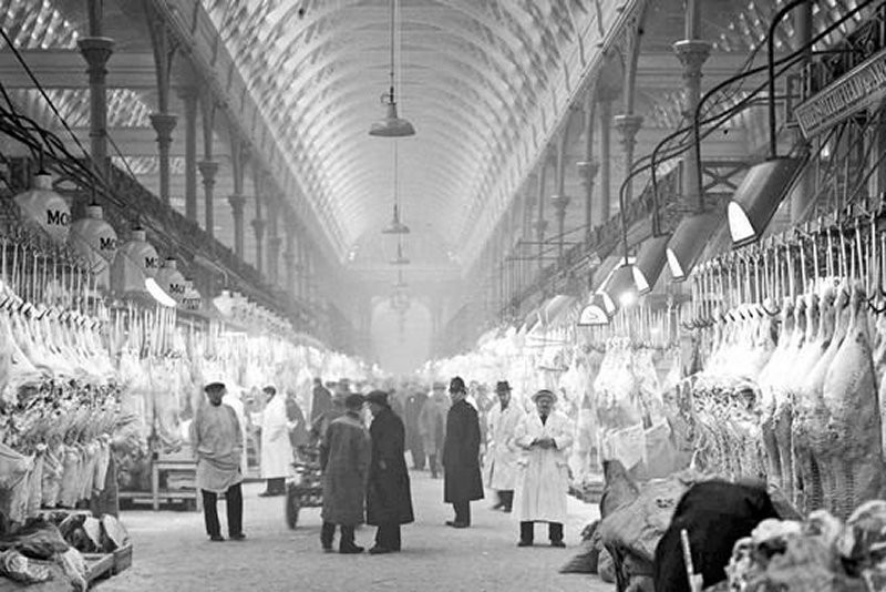
Amongst the notable buildings on Farringdon Road are the former headquarters of The Guardian newspaper at No. 119, the so-called Zeppelin Building at No. 61 built in 1917 after a Zeppelin raid during the First World War, and the western side of Smithfield Market.

A notorious building on the street was the Farringdon Road Buildings, a five-tenement block of dwellings built for the working classes during the Victorian era. Lacking bathrooms and with poor sanitary conditions this building, one of the last slum dwellings existing in central London, was still occupied until the early 1970s. Common features were poor lighting, overcrowding, with rat- and cockroach-infested living conditions, and people trapped by their own poverty. The residents were re-housed by Islington Borough Council and the buildings, close to Exmouth Market and the Royal Mail Mount Pleasant Sorting Office, were pulled down in the mid-1970s to be replaced by a multi-storey car park.


Main source: Survey of London
Further citations and sources


Click here to explore another London street
We now have 666 completed street histories and 46834 partial histories
Find streets or residential blocks within the M25 by clicking STREETS


CONTRIBUTIONS TO THE LOCALITY

None so far :(
LATEST LONDON-WIDE CONTRIBUTIONS TO THE PROJECT

Comment
Tony Whipple   
Added: 16 Apr 2024 21:35 GMT   

Frank Whipple Place, E14
Frank was my great-uncle, I’d often be ’babysat’ by Peggy while Nan and Dad went to the pub. Peggy was a marvel, so full of life. My Dad and Frank didn’t agree on most politics but everyone in the family is proud of him. A genuinely nice, knowledgable bloke. One of a kind.

Reply
Comment
Theresa Penney   
Added: 16 Apr 2024 18:08 GMT   

1 Whites Row
My 2 x great grandparents and his family lived here according to the 1841 census. They were Dutch Ashkenazi Jews born in Amsterdam at the beginning of the 19th century but all their children were born in Spitalfields.

Reply
Comment
Wendy    
Added: 22 Mar 2024 15:33 GMT   

Polygon Buildings
Following the demolition of the Polygon, and prior to the construction of Oakshott Court in 1974, 4 tenement type blocks of flats were built on the site at Clarendon Sq/Phoenix Rd called Polygon Buildings. These were primarily for people working for the Midland Railway and subsequently British Rail. My family lived for 5 years in Block C in the 1950s. It seems that very few photos exist of these buildings.

Reply

Steve   
Added: 19 Mar 2024 08:42 GMT   

Road construction and houses completed
New Charleville Circus road layout shown on Stanford’s Library Map Of London And Its Suburbs 1879 with access via West Hill only.

Plans showing street numbering were recorded in 1888 so we can concluded the houses in Charleville Circus were built by this date.

Source: Charleville Circus, Sydenham, London

Reply
Comment
Steve   
Added: 19 Mar 2024 08:04 GMT   

Charleville Circus, Sydenham: One Place Study (OPS)
One Place Study’s (OPS) are a recent innovation to research and record historical facts/events/people focused on a single place �’ building, street, town etc.

I have created an open access OPS of Charleville Circus on WikiTree that has over a million members across the globe working on a single family tree for everyone to enjoy, for free, forever.

Source: Charleville Circus, Sydenham, London

Reply
Comment
Charles   
Added: 8 Mar 2024 20:45 GMT   

My House
I want to know who lived in my house in the 1860’s.

Reply

NH   
Added: 7 Mar 2024 11:41 GMT   

Telephone House
Donald Hunter House, formerly Telephone House, was the BT Offices closed in 2000

Reply
Comment
Paul Cox   
Added: 5 Mar 2024 22:18 GMT   

War damage reinstatement plans of No’s 11 & 13 Aldine Street
Whilst clearing my elderly Mothers house of general detritus, I’ve come across original plans (one on acetate) of No’s 11 & 13 Aldine Street. Might they be of interest or should I just dispose of them? There are 4 copies seemingly from the one single acetate example. Seems a shame to just junk them as the level of detail is exquisite. No worries if of no interest, but thought I’d put it out there.

Reply


LOCAL PHOTOS
Click here to see map view of nearby Creative Commons images
Click here to see Creative Commons images near to this postcode
Click here to see Creative Commons images tagged with this road (if applicable)
Smithfield Market
TUM image id: 1620388545
Licence:
The Grand Theatre, Islington High Street (1903) The new Grand Theatre - the fourth theatre on the site - was opened on 26 December 1900 with a production of the pantomime ’Robinson Crusoe’. The Huddersfield Daily reported the next day: "Nearing the end of the first performance of ’Robinson Crusoe’ at the Grand Theatre, Islington, on Wednesday, a fire broke out. From all parts of the house an alarm was raised. All present rose to their feet as large pieces of inflammable material were seen dropping from flies. The fire-proof curtain was promptly lowered, and the band struck up the National Anthem. The actors and actresses crowded into the stage boxes. Mr. Jones, playing ’Friday,’ clambered on to the stage from the front and appealed to the audience not to rush for the doors as there was no danger. Then Mr. Charles Townley, the author, came forward explaining that the management, owing to the electric installations not being completed, had used gas batten, and one of the sky borders had unfortunately caught fire. The officials had shown their efficiency by the celerity with which the fire had been extinguished. This is the fourth fire that has occurred at this theatre, and Wednesday’s was the first performance given since the building was gutted some few months back." Thankfully the fire was quickly put out and the performance continued, and the Theatre would go on to stage pantomime, drama, and variety productions until it was renamed the Islington Empire in 1908.
TUM image id: 1557151038
Licence:
Amen Court, EC4M
TUM image id: 1493474208
Licence: CC BY 2.0

In the neighbourhood...

Click an image below for a better view...
Smithfield Market
Licence:


Sadler House on the Spa Green Estate from Rosebery Avenue (2011) The ’organic’ connection between old and new buildings intended by architect Berthold Lubetkin at Spa Green.
Credit: Wiki Commons/Grantham9
Licence: CC BY 2.0


Mount Pleasant Sorting Office on the north-east corner of Farringdon Road (1910). The present building is on the site of the Coldbath Fields Prison where the punishments were particularly cruel in that they were not only long and physically hard but also pointless. The pub at the back used to open at 9am to serve postal workers.
Licence:


View looking upwards of the stairway at Bevin Court. Bevin Court (1946-54) designed by Berthold Lubetkin and Tecton.
Credit: Wiki Commons/Steve Cadman
Licence:


Clerkenwell Green (1898) The water fountain shown here became public toilets.
Licence:


Coldbath Square in Clerkenwell was named after a cold water well that stood originally in fields. Cold Bath was fed by a spring which was discovered by a Mr Baynes in 1697. The discoverer declared the water had great power in nervous diseases, and "equalled those of St Magnus and St Winnifred". The bathing hours were from 5am to 1pm, the charge two shillings. The old bathhouse was a building with three gables, and had a large garden with four turret summer houses. In 1811 the trustees of the London Fever Hospital bought the property for £3830, but, being driven away by the frightened inhabitants, the ground was sold for building, the bath remaining as late as 1865.
Licence:


Doughty Street is a broad tree lined street in the Holborn district.
Licence:


Pluto Lamps were first demonstrated in 1897. They included an automatic machine that could dispense a gallon of hot water, or a halfpenny worth of beef tea essence, cocoa, milk, sugar, tea or coffee. Pictured here is the inauguration of the first Pluto lamp in Exmouth Street (now Exmouth Market), Clerkenwell 1899. The Pluto Lamps initiative disappeared almost as quickly as it arrived.
Credit: Islington Local History Centre
Licence:


Eyre Street Hill, Little Italy, c. 1890
Credit: Bishopsgate Institute
Licence: CC BY 2.0


John Street, looking up Doughty Street (1949)
Credit: Rene Groebli
Licence: CC BY 2.0


  Contact us · Copyright policy · Privacy policy