Wood Lane, W12

Road in/near White City, existing between the 1700s and now.

 HOME  ·  ARTICLE  ·  MAPS  ·  STREETS  ·  BLOG  ·  CONTACT US 
(51.51107 -0.2248, 51.511 -0.224) 
MAP YEAR:175018001810182018301860190019502024Show map without markers
TIP: To create your own sharable map, right click on the map
 
Road · * · W12 ·
APRIL
7
2015
Wood Lane runs from Shepherd’s Bush to Wormwood Scrubs and lies wholly in London W12.

In the 1780s, Wood Lane was known as Turvens Lane after Turvens House located a short distance north of Shepherd's Bush Green. By the 1830s it had received its current name.

In the 1860s the railway arrived with a line running parallel with Wood Lane but the area was still rural in character with the buildings of Wood Lane Farm and Eynam Farm to the east of the road and a plant nursery to the west covering the land east of present day Frithville Gardens and south of the BBC Television centre.

The coming of the Twopenny Tube - the Central London Railway opening between Shepherd's Bush and Bank in 1900 saw the first industrial development as the company's new depot, repair shops and power station located onto a 20 acre site at Wood Lane. The depot was also served by a single track spur from the West London Railway which was used to bring coal to the power station.

In 1905 the French Chamber of Commerce proposed holding a Franco-British Exhibition in London to promote the industrial achievements of both countries. It was to be a very opulent affair housed in a spectacular setting, built on 140 acres of former farm land on the west side of Wood Lane.

The plan got the Royal seal of approval and work started in January 1907 with contractors working round the clock to complete the exhibition site within a year. The majority of exhibition buildings were constructed on an impressive scale and set amongst specially laid-out gardens and waterways. Most of the buildings featured highly ornamented plastered exteriors which were weather-proofed with white paint and the site quickly became known locally as the ‘White City’. The exhibition area also included a large stadium to accommodate 150,000 spectators and was built to host the 1908 Olympic Games.

The closest existing stations were Shepherds Bush on the Central London Railway and the adjacent Uxbridge Road on the West London Line. Both stations fronted onto Uxbridge Road and were nearly half a mile away from the exhibition site by road. To overcome this an exhibition entrance was built between the two stations from where a raised arcaded walkway incorporating exhibition halls was built 30' above railway owned land linking the two stations with the exhibition site.


Old cottages in Wood Lane, Shepherd's Bush, c. 1890.
(click image to enlarge)


It was soon clear that the walkway would not be adequate and in July 1907 the Central London Railway received parliamentary consent to extend northwards from its Shepherds Bush terminus to a new station at Wood Lane. The station was to be sited on a single-track loop in the northwest corner of their depot.

The area to the west of Wood Lane, north of the current Loftus Road stadium, south of Du Cane Road and east of Bloemfontein Road was laid out as the exhibition site. The numerous pavilions faced with white stone earned the exhibition the nickname "the White City" which subsequently remained with the area, even after the exhibition closed and its pavilions were demolished.

The 1908 Summer Olympics came to London. These games were originally scheduled to be held in Rome, but were re-located on financial grounds following a disastrous eruption of Mt Vesuvius in 1906.

White City Stadium (originally The Great Stadium) was then built on Wood Lane on the exhibition site for the 1908 Summer Olympics and is often seen as the precursor to the modern seated stadium and noted for hosting the finish of the first modern distance marathon. It also hosted greyhound racing, was briefly the QPR football club's home ground and also hosted speedway and a match at the 1966 World Cup, before the stadium was demolished in 1985. It was the first Olympic Stadium in the UK.

The BBC Television Centre on Wood Lane was the headquarters of BBC Television between 1960 and 2013. Officially opened on 29 June 1960, parts of the building are Grade II listed, including the central ring and Studio 1.

In the 2000s, the massive Westfield Centre was opened at the southern end of Wood Lane and a new underground station on the Hammersmith and City Line opened to serve it.


Main source: Wikipedia, the free encyclopedia
Further citations and sources


Click here to explore another London street
We now have 666 completed street histories and 46834 partial histories
Find streets or residential blocks within the M25 by clicking STREETS


CONTRIBUTIONS TO THE LOCALITY

Born here
Susan Wright   
Added: 16 Sep 2017 22:42 GMT   

Ada Crowe, 9 Bramley Mews
My Great Grandmother Ada Crowe was born in 9 Bramley Mews in 1876.

Reply
Lived here
Norman Norrington   
Added: 28 Dec 2020 08:31 GMT   

Blechynden Street, W10
I was born in Hammersmith Hospital (Ducane Rd) I lived at 40 Blecynden Street from birth in 1942 to 1967 when I moved due to oncoming demolition for the West way flyover.
A bomb fell locally during the war and cracked one of our windows, that crack was still there the day I left.
It was a great street to have grown up in I have very fond memories of living there.


Reply
Reply
john ormandy   
Added: 20 Mar 2021 17:30 GMT   

Blechynden Street, W10
Went to school St Johns with someone named Barry Green who lived in that St. Use to wait for him on the corner take a slow walk an end up being late most days.

Reply
Lived here
Norman Norrington   
Added: 8 Jun 2021 08:08 GMT   

Blechynden Street, W10
Lived here #40 1942-1967

Reply
Lived here
David James Bloomfield   
Added: 13 Jul 2021 11:54 GMT   

Hurstway Street, W10
Jimmy Bloomfield who played for Arsenal in the 1950s was brought up on this street. He was a QPR supporter as a child, as many locals would be at the time, as a teen he was rejected by them as being too small. They’d made a mistake

Reply

LATEST LONDON-WIDE CONTRIBUTIONS TO THE PROJECT

Comment
Tony Whipple   
Added: 16 Apr 2024 21:35 GMT   

Frank Whipple Place, E14
Frank was my great-uncle, I’d often be ’babysat’ by Peggy while Nan and Dad went to the pub. Peggy was a marvel, so full of life. My Dad and Frank didn’t agree on most politics but everyone in the family is proud of him. A genuinely nice, knowledgable bloke. One of a kind.

Reply
Comment
Theresa Penney   
Added: 16 Apr 2024 18:08 GMT   

1 Whites Row
My 2 x great grandparents and his family lived here according to the 1841 census. They were Dutch Ashkenazi Jews born in Amsterdam at the beginning of the 19th century but all their children were born in Spitalfields.

Reply
Comment
Wendy    
Added: 22 Mar 2024 15:33 GMT   

Polygon Buildings
Following the demolition of the Polygon, and prior to the construction of Oakshott Court in 1974, 4 tenement type blocks of flats were built on the site at Clarendon Sq/Phoenix Rd called Polygon Buildings. These were primarily for people working for the Midland Railway and subsequently British Rail. My family lived for 5 years in Block C in the 1950s. It seems that very few photos exist of these buildings.

Reply

Steve   
Added: 19 Mar 2024 08:42 GMT   

Road construction and houses completed
New Charleville Circus road layout shown on Stanford’s Library Map Of London And Its Suburbs 1879 with access via West Hill only.

Plans showing street numbering were recorded in 1888 so we can concluded the houses in Charleville Circus were built by this date.

Source: Charleville Circus, Sydenham, London

Reply
Comment
Steve   
Added: 19 Mar 2024 08:04 GMT   

Charleville Circus, Sydenham: One Place Study (OPS)
One Place Study’s (OPS) are a recent innovation to research and record historical facts/events/people focused on a single place �’ building, street, town etc.

I have created an open access OPS of Charleville Circus on WikiTree that has over a million members across the globe working on a single family tree for everyone to enjoy, for free, forever.

Source: Charleville Circus, Sydenham, London

Reply
Comment
Charles   
Added: 8 Mar 2024 20:45 GMT   

My House
I want to know who lived in my house in the 1860’s.

Reply

NH   
Added: 7 Mar 2024 11:41 GMT   

Telephone House
Donald Hunter House, formerly Telephone House, was the BT Offices closed in 2000

Reply
Comment
Paul Cox   
Added: 5 Mar 2024 22:18 GMT   

War damage reinstatement plans of No’s 11 & 13 Aldine Street
Whilst clearing my elderly Mothers house of general detritus, I’ve come across original plans (one on acetate) of No’s 11 & 13 Aldine Street. Might they be of interest or should I just dispose of them? There are 4 copies seemingly from the one single acetate example. Seems a shame to just junk them as the level of detail is exquisite. No worries if of no interest, but thought I’d put it out there.

Reply
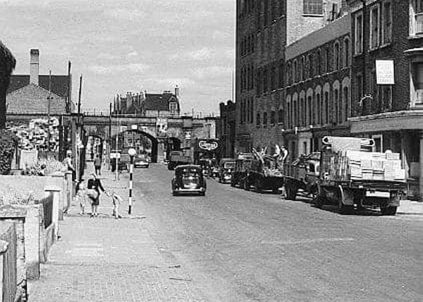
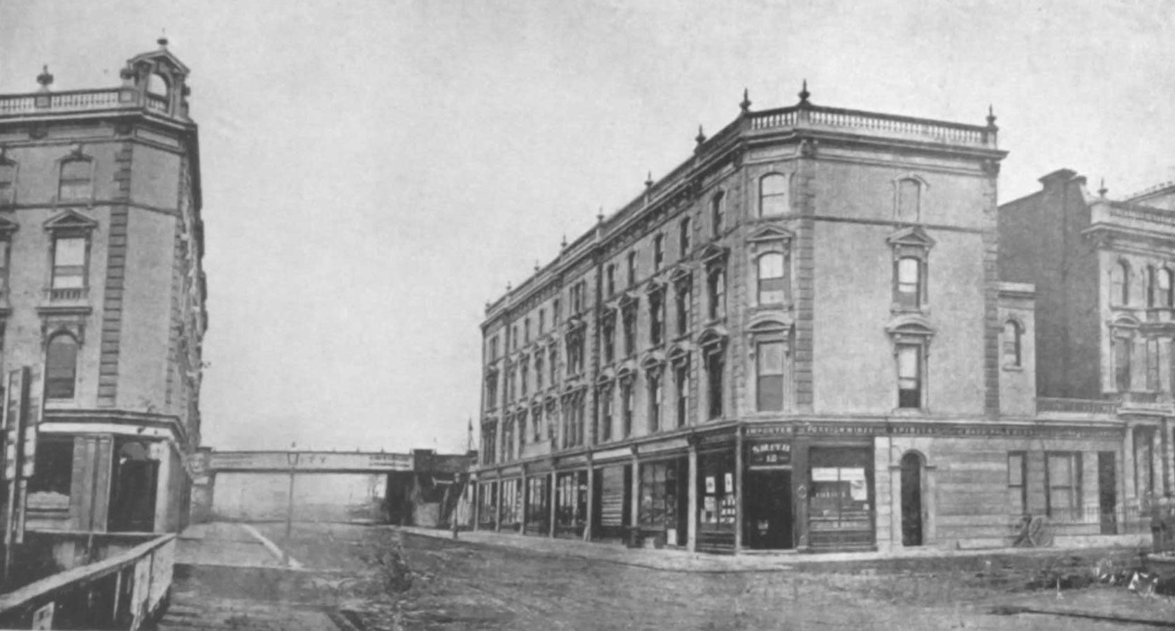
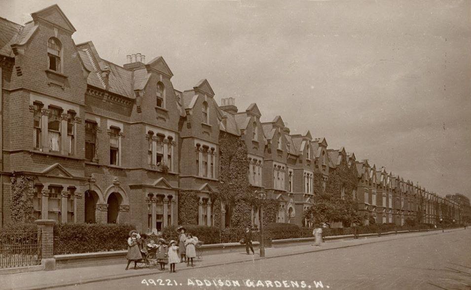


LOCAL PHOTOS
Click here to see map view of nearby Creative Commons images
Click here to see Creative Commons images near to this postcode
Click here to see Creative Commons images tagged with this road (if applicable)
Ansleigh Place, W11
TUM image id: 1453967815
Licence: CC BY 2.0
Kenilworth Castle
TUM image id: 1453901412
Licence: CC BY 2.0
Princess Louise Hospital
TUM image id: 1490700922
Licence: CC BY 2.0

In the neighbourhood...

Click an image below for a better view...
Percy Thrower and John Noakes in the Blue Peter Garden, White City (1975)
Credit: BBC
Licence:


London West Ten
Credit: The Underground Map
Licence:


Local resident Trevor who grew tomatoes in compost made from Frestonian residents’ waste. Frestonia was the name adopted by the residents of Freston Road, London W11, when they attempted to secede from the United Kingdom in 1977 to form the Free and Independent Republic of Frestonia. Many residents eventually set up a housing co-op in negotiation with Notting Hill Housing Trust, and included artists, musicians, writers, actors and activists. Actor David Rappaport was the Frestonia Foreign Minister while playwright Heathcote Williams served as Ambassador to the United Kingdom.
Licence:


Martin Street, looking west (1960s) Martin Street disappeared from the map as the Latimer Road area was redeveloped in the late 1960s
Licence:


Wood Lane station, c.1914
Licence:


White City Close
Credit: GoArt/The Underground Map
Licence: CC BY 2.0


The Wellington Arms, c. 1900 Tatcho (advertised on a hoarding) was a brand of hair restorer.
Licence:


Latimer Road as featured in the film ’The Blue Lamp’ (1950). Just past the tall (out-of-sight) Latimer Road school building and printers was the patent steam carpet cleaners as is Bramley Road’s Bramley Arms with Latimer Road School further on down through the arches on the right.
Credit: Ealing Studios
Licence:


Wood Lane station, MacFarlane Place entrance (1937)
Licence:


Gardener’s Cottage, Wood House, Wood Lane (1880) In 1894, the grounds called Woodhouse Park were opened to the public, with ornamental gardens, ballooning, lawn tennis and a model of Stonehenge.
Licence: CC BY 2.0


  Contact us · Copyright policy · Privacy policy