Royal Aeronautical Society

Club in/near Mayfair, existing between 1866 and now.

 HOME  ·  ARTICLE  ·  MAPS  ·  STREETS  ·  BLOG  ·  CONTACT US 
(51.504265 -0.150356, 51.504 -0.15) 
MAP YEAR:175018001810182018301860190019502024Show map without markers
Use the control in the top right of the map above to view this area on another historic map
 
Club · * · W1J ·
December
10
2020
The Royal Aeronautical Society, also known as the RAeS, is a British-founded multidisciplinary professional institution dedicated to the global aerospace community.

The objectives of Society include: to support and maintain high professional standards in aerospace disciplines; to provide a unique source of specialist information and a local forum for the exchange of ideas; and to exert influence in the interests of aerospace in the public and industrial arenas.

The Society was founded in January 1866 with the name The Aeronautical Society of Great Britain. Early or founding members included James Glaisher, Francis Wenham, the Duke of Argyll, and Frederick Brearey. In the first year, there were 65 members. In 1868 the Society held a major exhibition at London’s Crystal Palace - John Stringfellow’s steam engine was shown there. The Society sponsored the first wind tunnel in 1870-71, designed by Wenham and Browning.

In 1918, the organization’s name was changed to the Royal Aeronautical Society.

During the 1940s, the RAeS responded to the wartime need to expand the aircraft industry. The Society established a Technical Department to bring together the best available knowledge and present it in an authoritative and accessible form – a working tool for engineers who might come from other industries and lack the specialised knowledge required for aircraft design. This technical department became known as the Engineering Sciences Data Unit (ESDU) and eventually became a separate entity in the 1980s.

In 1987 the Society of Licensed Aircraft Engineers and Technologists, previously called the Society of Licensed Aircraft Engineers, was incorporated into the Royal Aeronautical Society.

The Royal Aeronautical Society is now a worldwide society with an international network of nearly 70 branches. Many practitioners of aerospace disciplines use the Society’s designatory post-nominals such as FRAeS, CRAeS, MRAeS, AMRAeS and ARAeS.


Licence: Creative Commons Attribution-ShareAlike Licence


Click here to explore another London street
We now have 666 completed street histories and 46834 partial histories
Find streets or residential blocks within the M25 by clicking STREETS


CONTRIBUTIONS TO THE LOCALITY

Born here
www.violettrefusis.com   
Added: 17 Feb 2021 15:05 GMT   

Birth place
Violet Trefusis, writer, cosmopolitan intellectual and patron of the Arts was born at 2 Wilton Crescent SW1X.

Source: www.violettrefusis.com

Reply

LATEST LONDON-WIDE CONTRIBUTIONS TO THE PROJECT

Comment
Tony Whipple   
Added: 16 Apr 2024 21:35 GMT   

Frank Whipple Place, E14
Frank was my great-uncle, I’d often be ’babysat’ by Peggy while Nan and Dad went to the pub. Peggy was a marvel, so full of life. My Dad and Frank didn’t agree on most politics but everyone in the family is proud of him. A genuinely nice, knowledgable bloke. One of a kind.

Reply
Comment
Theresa Penney   
Added: 16 Apr 2024 18:08 GMT   

1 Whites Row
My 2 x great grandparents and his family lived here according to the 1841 census. They were Dutch Ashkenazi Jews born in Amsterdam at the beginning of the 19th century but all their children were born in Spitalfields.

Reply
Comment
Wendy    
Added: 22 Mar 2024 15:33 GMT   

Polygon Buildings
Following the demolition of the Polygon, and prior to the construction of Oakshott Court in 1974, 4 tenement type blocks of flats were built on the site at Clarendon Sq/Phoenix Rd called Polygon Buildings. These were primarily for people working for the Midland Railway and subsequently British Rail. My family lived for 5 years in Block C in the 1950s. It seems that very few photos exist of these buildings.

Reply

Steve   
Added: 19 Mar 2024 08:42 GMT   

Road construction and houses completed
New Charleville Circus road layout shown on Stanford’s Library Map Of London And Its Suburbs 1879 with access via West Hill only.

Plans showing street numbering were recorded in 1888 so we can concluded the houses in Charleville Circus were built by this date.

Source: Charleville Circus, Sydenham, London

Reply
Comment
Steve   
Added: 19 Mar 2024 08:04 GMT   

Charleville Circus, Sydenham: One Place Study (OPS)
One Place Study’s (OPS) are a recent innovation to research and record historical facts/events/people focused on a single place �’ building, street, town etc.

I have created an open access OPS of Charleville Circus on WikiTree that has over a million members across the globe working on a single family tree for everyone to enjoy, for free, forever.

Source: Charleville Circus, Sydenham, London

Reply
Comment
Charles   
Added: 8 Mar 2024 20:45 GMT   

My House
I want to know who lived in my house in the 1860’s.

Reply

NH   
Added: 7 Mar 2024 11:41 GMT   

Telephone House
Donald Hunter House, formerly Telephone House, was the BT Offices closed in 2000

Reply
Comment
Paul Cox   
Added: 5 Mar 2024 22:18 GMT   

War damage reinstatement plans of No’s 11 & 13 Aldine Street
Whilst clearing my elderly Mothers house of general detritus, I’ve come across original plans (one on acetate) of No’s 11 & 13 Aldine Street. Might they be of interest or should I just dispose of them? There are 4 copies seemingly from the one single acetate example. Seems a shame to just junk them as the level of detail is exquisite. No worries if of no interest, but thought I’d put it out there.

Reply


LOCAL PHOTOS
Click here to see map view of nearby Creative Commons images
Click here to see Creative Commons images near to this postcode
The 52 bus
TUM image id: 1556876554
Licence:

In the neighbourhood...

Click an image below for a better view...
Wellington Arch (1850s) Wellington Arch was built as an original entrance to Buckingham Palace, later becoming a victory arch proclaiming Wellington’s defeat of Napoleon. Crowned by the largest bronze sculpture in Europe, it depicts the Angel of Peace descending on the ’Quadriga’ - or four-horsed chariot - of War
Licence:


Exterior of the memorial in 2013.
Credit: Tim Rademacher
Licence: CC BY 2.0


The 52 bus
Licence:


Wellington Arch photographed on 10 January 2017. Wellington Arch was built as an original entrance to Buckingham Palace, later becoming a victory arch proclaiming Wellington’s defeat of Napoleon. Crowned by the largest bronze sculpture in Europe, it depicts the Angel of Peace descending on the ’Quadriga’ - or four-horsed chariot - of War. The pathway that runs underneath the arch has a formal name - Apsley Way.
Credit: The Underground Map
Licence:


Belgrave Square - this was classed in contemporary reports as "Thomas Cubitt’s greatest achievement". Belgrave Square, is the grandest and largest of his squares.
Credit: Thomas Shepherd
Licence:


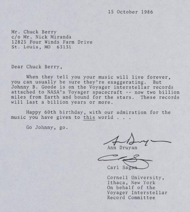
Letter to Chuck Berry from Carl Sagan (1986)
Licence:


Grosvenor Gardens Mews East
Licence:


Hyde Park Corner in 1842, looking east towards Piccadilly. The entrance to Hyde Park through Decimus Burton’s Ionic Screen is on the left, and behind it, in darker stone, is Apsley House.
Licence:


Lowndes Street, c. 1905.
Licence: CC BY 2.0


Motcomb Street (2021)
Credit: The Underground Map
Licence: CC BY 2.0


  Contact us · Copyright policy · Privacy policy