Wapping

Underground station, existing between 1869 and now.

 HOME  ·  ARTICLE  ·  MAPS  ·  STREETS  ·  BLOG  ·  CONTACT US 
(51.504 -0.056, 51.504 -0.056) 
MAP YEAR:175018001810182018301860190019502024Show map without markers
Use the control in the top right of the map above to view this area on another historic map
 
Underground station · * · E1W ·
APRIL
10
2014
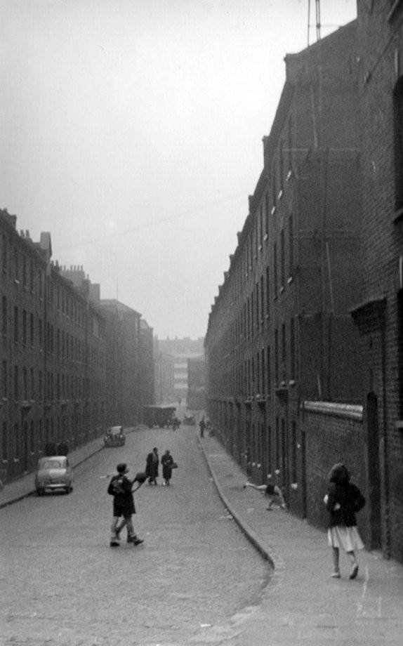
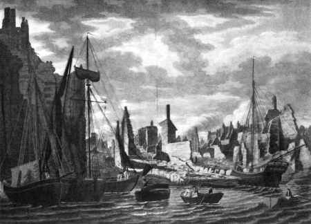
Wapping’s proximity to the Thames has given the area a strong maritime character, which it retains through its riverside public houses and steps.

The area was first settled by Saxons, from whom it takes its name (meaning literally [the place of] Wæppa’s people). It developed along the embankment of the Thames, hemmed in by the river to the south and the now-drained Wapping Marsh to the north. This gave it a peculiarly narrow and constricted shape, consisting of little more than the axis of Wapping High Street and some north-south side streets. John Stow, the 16th century historian, described it as a "continual street, or a filthy strait passage, with alleys of small tenements or cottages, built, inhabited by sailors’ victuallers".

Wapping was inhabited by sailors, mastmakers, boat-builders, blockmakers, instrument-makers, victuallers and representatives of all the other trades that supported the seafarer. Wapping was also the site of ’Execution Dock’, where pirates and other water-borne criminals faced execution by hanging from a gibbet constructed close to the low water mark. Their bodies would be left dangling until they had been submerged three times by the tide. Though Execution Dock is long gone, this gibbet is still maintained on the Thames foreshore by the Prospect of Whitby public house

Said to be England’s first, the Marine Police Force was formed in 1798 by magistrate Patrick Colquhoun and a Master Mariner, John Harriott, to tackle theft and looting from ships anchored in the Pool of London and the lower reaches of the river. Its base was (and remains) in Wapping High Street and it is now known as the Marine Support Unit. The Thames Police Museum, dedicated to the history of the Marine Police Force, is currently housed within the headquarters of the Marine Support Unit, and is open to the public by appointment.

In 1811, the horrific Ratcliff Highway murders took place nearby at The Highway and Wapping Lane.

The area’s strong maritime associations changed radically in the 19th century when the London Docks were built to the north and west of the High Street. Wapping’s population plummeted by nearly 60% during that century, with many houses destroyed by the construction of the docks and giant warehouses along the riverfront. Squeezed between the high walls of the docks and warehouses, the district became isolated from the rest of London, although some relief was provided by Brunel’s Thames Tunnel to Rotherhithe. The opening of Wapping tube station on the East London Line in 1869 provided a direct rail link to the rest of London.

Wapping was devastated by German bombing in World War II and by the post-war closure of the docks. It remained a run-down and derelict area into the 1980s, when the area was transferred to the management of the London Docklands Development Corporation, a government quango with the task of redeveloping the Docklands. The London Docks were largely filled in and redeveloped with a variety of commercial, light industrial and residential properties.

In 1986, Rupert Murdoch’s News International built a new £80m printing and publishing works in the north of Wapping. This became the scene of violent protests after News International’s UK operation moved from Fleet Street to Wapping, with over 5,000 print workers being sacked when new technology was introduced.

Perhaps Wapping’s greatest attraction is the Thames foreshore itself, and the venerable public houses that face onto it. A number of the old ’stairs’, such as Wapping Old Stairs and Pelican Stairs (by the Prospect of Whitby) give public access to a littoral zone (for the Thames is tidal at this point) littered with flotsam, jetsam and fragments of old dock installations. Understandably it is popular with amateur archaeologists and treasure hunters - it is surprisingly easy for even a casual visitor to pick up a centuries-old shard of pottery here.

Three venerable public houses are located near Stairs. By Pelican Stairs is the Prospect of Whitby, which has a much-disputed claim to be the oldest Thames-side public house still in existence. Be that as it may, there has been an inn on the site since the reign of Henry VIII, and it is certainly one of the most famous public houses in London. It is named after a then-famous collier that used to dock regularly at Wapping. A replica of the old Execution Dock gibbet is maintained on the adjacent foreshore, although the actual site of Execution Dock was nearer to the Town of Ramsgate. This also is on the site of a 16th-century inn and is located next to Wapping Old Stairs to the west of the Prospect; by Wapping Pier Head — the former local headquarters of the Customs and Excise.

Wapping has been used as the setting for a number of works of fiction, including The Long Good Friday; the Ruby In The Smoke novel in the Sally Lockhart series by Phillip Pullman and the brothel in The Threepenny Opera, in which Mack the Knife is betrayed by Jenny Diver.

Among the people born in Wapping are W.W. Jacobs, author of The Monkey’s Paw. The American painter James McNeill Whistler, well known for his Thames views, painted Wapping when he lived here between October 1860 and 1864. John Newton, Anglican clergyman and author of many hymns including Amazing Grace was born here. During the 1990s, Wapping was home to American entertainer Cher.


Licence: Creative Commons Attribution-ShareAlike Licence


Click here to explore another London street
We now have 666 completed street histories and 46834 partial histories
Find streets or residential blocks within the M25 by clicking STREETS


CONTRIBUTIONS TO THE LOCALITY

None so far :(
LATEST LONDON-WIDE CONTRIBUTIONS TO THE PROJECT

Comment
Tony Whipple   
Added: 16 Apr 2024 21:35 GMT   

Frank Whipple Place, E14
Frank was my great-uncle, I’d often be ’babysat’ by Peggy while Nan and Dad went to the pub. Peggy was a marvel, so full of life. My Dad and Frank didn’t agree on most politics but everyone in the family is proud of him. A genuinely nice, knowledgable bloke. One of a kind.

Reply
Comment
Theresa Penney   
Added: 16 Apr 2024 18:08 GMT   

1 Whites Row
My 2 x great grandparents and his family lived here according to the 1841 census. They were Dutch Ashkenazi Jews born in Amsterdam at the beginning of the 19th century but all their children were born in Spitalfields.

Reply
Comment
Wendy    
Added: 22 Mar 2024 15:33 GMT   

Polygon Buildings
Following the demolition of the Polygon, and prior to the construction of Oakshott Court in 1974, 4 tenement type blocks of flats were built on the site at Clarendon Sq/Phoenix Rd called Polygon Buildings. These were primarily for people working for the Midland Railway and subsequently British Rail. My family lived for 5 years in Block C in the 1950s. It seems that very few photos exist of these buildings.

Reply

Steve   
Added: 19 Mar 2024 08:42 GMT   

Road construction and houses completed
New Charleville Circus road layout shown on Stanford’s Library Map Of London And Its Suburbs 1879 with access via West Hill only.

Plans showing street numbering were recorded in 1888 so we can concluded the houses in Charleville Circus were built by this date.

Source: Charleville Circus, Sydenham, London

Reply
Comment
Steve   
Added: 19 Mar 2024 08:04 GMT   

Charleville Circus, Sydenham: One Place Study (OPS)
One Place Study’s (OPS) are a recent innovation to research and record historical facts/events/people focused on a single place �’ building, street, town etc.

I have created an open access OPS of Charleville Circus on WikiTree that has over a million members across the globe working on a single family tree for everyone to enjoy, for free, forever.

Source: Charleville Circus, Sydenham, London

Reply
Comment
Charles   
Added: 8 Mar 2024 20:45 GMT   

My House
I want to know who lived in my house in the 1860’s.

Reply

NH   
Added: 7 Mar 2024 11:41 GMT   

Telephone House
Donald Hunter House, formerly Telephone House, was the BT Offices closed in 2000

Reply
Comment
Paul Cox   
Added: 5 Mar 2024 22:18 GMT   

War damage reinstatement plans of No’s 11 & 13 Aldine Street
Whilst clearing my elderly Mothers house of general detritus, I’ve come across original plans (one on acetate) of No’s 11 & 13 Aldine Street. Might they be of interest or should I just dispose of them? There are 4 copies seemingly from the one single acetate example. Seems a shame to just junk them as the level of detail is exquisite. No worries if of no interest, but thought I’d put it out there.

Reply


NEARBY LOCATIONS OF NOTE
Brunel Museum The Brunel Museum is a museum at the Brunel Engine House in Rotherhithe.
Canary Wharf to Canada Water walk An unusual walk between stations on the Jubilee Line which involves asphyxiation
Execution Dock Execution Dock, on the shoreline at Wapping, was used to execute pirates, smugglers and mutineers who had been sentenced to death by Admiralty courts.
Lowder Street (1918) Lowder Street in Wapping at the end of the First World War.
St. Mary’s Church, Rotherhithe St Mary’s Church, Rotherhithe, is a Church of England parish church.
Thames Tunnel The Thames Tunnel connects Rotherhithe and Wapping and was built between 1825 and 1843.
The Angel The Angel Public House is grade II listed and dates from the 1830s.

NEARBY STREETS
, E1W A street within the E1W postcode
Agatha Close, E1W Agatha Close is a modern redevelopment
Agatha Street, E1W St James’s Place, marked on 1860s mapping, was renamed as Agatha Street in 1897
Ainsty Street, SE16 York Street until 1873, Ainsty Street was one of a group of Rotherhithe Streets commemorating royal names (Rotherhithe)
Albion Street, SE16 Albion Street’s name can be traced back to its proximity to Albion Dock, which was opened in 1860 (Rotherhithe)
Amos Court, E1W Amos Court, off Wapping High Street, was previously Church Court (Wapping)
Angelica Warehouse, SE16 The Angelica Warehouse is a block facing the River Thames (Rotherhithe)
Anne Boleyn House, E1W Anne Boleyn House is a block on Pearl Street
Ariel House, E1W Ariel House is sited on Vaughan Way
Asher Way, E1W Asher Way is one of the streets of London in the E1W postal area
Balkan Walk, E1W Balkan Walk is one of the streets of London in the E1W postal area
Baltic Court, E1W Baltic Court is a block on Clave Street (Wapping)
Beechey House, E1W Beechey House is a block on Watts Street
Benson Quay, E1W Benson Quay is a road in the E1W postcode area
Bermondsey Wall East, SE16 Bermondsey Wall East is part of the former contiguous Bermondsey Wall (Bermondsey)
Binnacle House, E1W Binnacle House is a building on Cobblestone Square
Bombay Court, SE16 Bombay Court is a block on St Marychurch Street (Rotherhithe)
Brewhouse Lane, E1W Brewhouse Lane is a road in the E1W postcode area
Bridewell Place, E1W A street within the E1W postcode
Bridgeport Place, E1W A street within the E1W postcode
Brunel Court, SE16 Brunel Court is sited on Brunel Road (Rotherhithe)
Brunel Engine House, SE16 Brunel Engine House can be found on Railway Avenue (Rotherhithe)
Brunel Road, SE16 Brunel Road is situated near the south end of Thames Tunnel which the engineer Marc Isambard Brunel built (Rotherhithe)
Canon Beck Road, SE16 Canon Beck Road is one of the streets of London in the SE16 postal area (Rotherhithe)
Capstan Court, E1W Capstan Court can be found on Wapping Wall
Carronade House, E1W Carronade House is a block on Wapping High Street (Wapping)
Cathay House, SE16 Cathay House is a block on Cathay Street (Bermondsey)
Chancellor House, E1W Chancellor House is a block on Greenbank
Chandler Street, E1W Chandler Street is a road in the E1W postcode area
Chigwell Hill, E1W Chigwell Hill is a road in the E1W postcode area
Chimney Court, E1W Chimney Court is a block on Brewhouse Lane
China Court, E1W China Court is a block on Asher Way
Choppins Court, E1W Choppins Court is a building on Choppins Court
Cinnamon Street, E1W Cinnamon Street is a road in the E1W postcode area (Wapping)
Clack Street, SE16 Clack Street is a road in the SE16 postcode area (Rotherhithe)
Clarence Mews, SE16 A street within the SE16 postcode (Rotherhithe)
Clave Street, E1W Clave Street is a road in the E1W postcode area (Wapping)
Clegg Street, E1W A street within the E1W postcode (Wapping)
Clipper Close, SE16 Clipper Close is a short cul-de-sac (Rotherhithe)
Cobblestone Square, E1W A street within the E1W postcode
Collingwood House, SE16 Collingwood House is a location in London (Bermondsey)
Columbus Court, SE16 Columbus Court is a block on Rotherhithe Street (Rotherhithe)
Columbus House, E1W Columbus House is a block on Wapping Lane
Compass House, E1W Compass House is a block on Raine Street
Cook Court, SE16 Cook Court is sited on Rotherhithe Street (Rotherhithe)
Corbetts Wharf, SE16 Corbetts Wharf is an historic wharf of Bermondsey (Bermondsey)
Cordage House, E1W Cordage House is a block on Cobblestone Square
Cork Square, E1W A street within the E1W postcode
Cottle Lane, SE16 Cottle Lane is a road in the SE16 postcode area (Bermondsey)
Discovery Walk, E1W A street within the E1W postcode
Dolphin Close, SE16 Dolphin Close is a cul-de-sac off Kinburn Street (Rotherhithe)
Douthwaite Square, E1W A street within the E1W postcode
Dundee Court, E1W Dundee Court is a block on Wapping High Street (Wapping)
Dundee Street, E1W Dundee Street is one of the streets of London in the E1W postal area
East India Court, SE16 East India Court is a block on St Marychurch Street (Rotherhithe)
Elephant Lane, SE16 Elephant Lane is one of the streets of London in the SE16 postal area (Bermondsey)
Emery Way, E1W Emery Way is location of London
Execution Dock House, E1W Execution Dock House is a block on Wapping High Street (Wapping)
Fairmount House, SE16 A street within the SE16 postcode (Rotherhithe)
Falconet Court, E1W Falconet Court is a block on Wapping High Street (Wapping)
Farthing Fields, E1W A street within the E1W postcode
Fenner House, E1W Fenner House is a block on Watts Street
Flinders House, E1W Flinders House is located on Watts Street
Fowey Close, E1W A street within the E1W postcode
Frank Whymark House, SE16 Frank Whymark House is sited on Brunel Road (Rotherhithe)
Franklin House, E1W Franklin House is a block on Watts Street
Frobisher House, E1W Frobisher House is located on Watts Street
Fulford Street, SE16 Fulford Street is a road in the SE16 postcode area (Bermondsey)
Fuschia Court, E1W Fuschia Court is a residential block in Wapping
Garnet House, E1W Garnet House is a block on Garnet Street
Garnet Street, E1W Garnet Street is one of the streets of London in the E1W postal area
Green Bank, E1W Green Bank is one of the streets of London in the E1W postal area
Greenbank, E1W Greenbank is a road in the E1W postcode area
Gun Court, E1W Gun Court can be found on Wapping Lane
Gun House, E1W Gun House is a block on Wapping High Street (Wapping)
Gun Wharf, E1W Gun Wharf is a residential block and part of an historic wharf (Wapping)
Hatteraick Road, SE16 Hatteraick Road is a road in the SE16 postcode area (Rotherhithe)
Hellings Street, E1W A street within the E1W postcode
Henley Close, SE16 Henley Close is one of the streets of London in the SE16 postal area (Bermondsey)
Hermitage Court, E1W Hermitage Court is a block on Wapping High Street (Wapping)
Hermitage Wall, E1W Hermitage Wall is one of the streets of London in the E1W postal area
Hilliard House, E1W Hilliard House is sited on Prusom Street (Wapping)
Hilliards Court, E1W Hilliards Court is a road in the E1W postcode area (Wapping)
Hope Suffferance Wharf Granary House, SE16 Hope Suffferance Wharf Granary House is a block on Hope Wharf (Rotherhithe)
Hope Suffferance Wharf Stable House, SE16 Hope Suffferance Wharf Stable House is a block on Hope Wharf (Rotherhithe)
Horatio Court, SE16 Horatio Court is a block on Rotherhithe Street (Rotherhithe)
Hythe House, SE16 Hythe House can be found on Railway Avenue (Rotherhithe)
Inglefield Square, E1W A street within the E1W postcode
Ironside Close, SE16 Ironside Close is a road in the SE16 postcode area (Rotherhithe)
Jackman House, E1W Jackman House was created as part of the Wapping Housing Estate
John Rennie Walk, E1W A street within the E1W postcode
Keetons Road, E1W A street within the E1W postcode
Kennet Street, E1W Kennet Street is a road in the E1W postcode area
Kenning Street, SE16 Kenning Street was formerly a long cul-de-sac which became a through road in the twentieth century (Rotherhithe)
Kinburn Street, SE16 Kinburn Street is one of the streets of London in the SE16 postal area (Rotherhithe)
King Henry’s Stairs, E1W King Henry’s Stairs lead down to King Henry’s Wharf (Wapping)
King Stairs Close, SE16 King Stairs Close leads off Elephant Lane (Bermondsey)
Knighten Street, E1W Knighten Street follows the line of the former Russell’s Buildings
Leeward Court, E1W Leeward Court is a block on Asher Way
Lilley Close, E1W Lilley Close serves modern developments in Wapping
Lowder House, E1W Lowder House is a block on Wapping Lane
Mace Close, E1W A street within the E1W postcode
Malay House, E1W Malay House is a block on Prusom Street
Marble Quay, E1W Marble Quay is one of the streets of London in the E1W postal area
Martingale House, E1W Martingale House is a block on Raine Street
Maynards Quay, E1W Maynards Quay is one of the streets of London in the E1W postal area
Meeting House Alley, E1W Alley is a road in the E1W postcode area
Merchant Court, E1W Merchant Court can be found on Wapping Wall
Metropolitan Wharf, E1W Metropolitan Wharf is one of the streets of London in the E1W postal area
Milk Yard, E1W Milk Yard is a road in the E1W postcode area
Monza Building, E1W Monza Building is located on Monza Street
Monza Street, E1W Monza Street lies south of the Shadwell Basin
Moran House, E1W Moran House can be found on Wapping Lane
Morriss House, SE16 Morriss House is a building on Cherry Garden Street (Bermondsey)
Mountbatten Court, SE16 Mountbatten Court can be found on Rotherhithe Street (Rotherhithe)
National Terrace, SE16 National Terrace is one of the streets of London in the SE16 postal area (Bermondsey)
Nelson Court, SE16 Nelson Court is a block on Brunel Road (Rotherhithe)
New Archers Court, SE16 New Archers Court is located on Rotherhithe Street (Rotherhithe)
New Crane Place, E1W New Crane Place is one of the streets of London in the E1W postal area (Wapping)
New Crane Stairs, E1W New Crane Stairs is a road in the E1W postcode area (Wapping)
New Crane Wharf, E1W New Crane Wharf is one of the streets of London in the E1W postal area (Wapping)
Olivers Wharf, E1W A street within the E1W postcode (Wapping)
Orton Street, E1W Orton Street was, for most of its existence, Little Hermitage Street
Oswell House, E1W Oswell House is a block on Farthing Fields
Park Vista Tower, E1W Park Vista Tower can be found on Cobblestone Square
Parry House, E1W Parry House can be found on Watts Street
Pelican Stairs, E1W Pelican Stairs is a road in the E1W postcode area
Penang House, E1W Penang House can be found on Prusom Street
Penang Street, E1W Penang Street is a road in the E1W postcode area
Pier Head, E1W Pier Head is one of the streets of London in the E1W postal area (Wapping)
Pine House, SE16 Pine House is sited on Ainsty Street (Rotherhithe)
Plough Alley, E1W Plough Alley appears on the 1860 map
PO Box 4, E1W A street within the E1W postcode (Wapping)
Porters Walk, E1W Porters Walk is one of the streets of London in the E1W postal area
Portland Square, E1W Portland Square is one of the streets of London in the E1W postal area
Pottery Street, SE16 Pottery Street is a road in the SE16 postcode area (Bermondsey)
President Drive, E1W A street within the E1W postcode
Princes Court, E1W Princes Court is sited on Princes Court
Princes Tower, SE16 Princes Tower is a block on Rotherhithe Street (Rotherhithe)
Prospecourt Place, E1W A street within the E1W postcode
Prospect Place, E1W Prospect Place is a road in the E1W postcode area
Prusom Street, E1W Prusom Street is situated north of Wapping High Street
Railway Avenue, SE16 Railway Avenue is named after the East London lines which run through the parallel Thames Tunnel (Rotherhithe)
Raine Street, E1W Raine Street is one of the streets of London in the E1W postal area
Raine’s House, E1W Raine’s House is a block on Farthing Fields
Raleigh Court, SE16 Raleigh Court is a block on Clarence Mews (Rotherhithe)
Reardon House, E1W Reardon House is a block on Reardon Street
Reardon Path, E1W This is a street in the E1W postcode area
Reardon Street, E1W Reardon Street is one of the streets of London in the E1W postal area
Riverside Mansions, E1W Riverside Mansions is one of the streets of London in the E1W postal area
Roding Mews, E1W A street within the E1W postcode
Ross House, E1W Ross House is sited on Cinnamon Street (Wapping)
Rotherhithe Tunnel Approach Road, SE16 Rotherhithe Tunnel Approach Road is a road in the SE16 postcode area (Rotherhithe)
Rotherhithe Tunnel, SE16 The Rotherhithe Tunnel runs under the Thames (Rotherhithe)
Rye House, SE16 Rye House is a block on Kenning Street (Rotherhithe)
Sampson Street, E1W Sampson Street is one of the streets of London in the E1W postal area
Sandwich House, SE16 Sandwich House is a block between Hythe House and Winchelsea House (Rotherhithe)
Scandrett Street, E1W A street within the E1W postcode (Wapping)
Seaford House, SE16 Seaford House is a block on Rotherhithe Street (Rotherhithe)
Smeaton Street, E1W Smeaton Street is a road in the E1W postcode area
Smith’s Place, E1W Smith’s Place appears on maps of Wapping between 1750 and 1900
Spice Court, E1W Spice Court is a block on Asher Way
Spirit Quay, E1W Spirit Quay is one of the streets of London in the E1W postal area
St George Street, E1W Prior to the London County Council renaming programme of 1937, St George Street denoted part of the modern street called The Highway
St John’s Wharf, E1W The St John’s Wharves warehouses are now flats (Wapping)
St Johns Court, E1W St Johns Court is a block on Scandrett Street
St Katharine By The Tower, E1W St Katharine By The Tower is one of the streets of London in the E1W postal area
St Marychurch Street, SE16 St Marychurch Street is one of the streets of London in the SE16 postal area (Bermondsey)
Stevedore Street, E1W A street within the E1W postcode
Sun Walk, E1W Sun Walk is a road in the E1W postcode area
Swan Road, SE16 Swan Road runs northwest-southeast across Rotherhithe (Rotherhithe)
Tamarind Yard, E1W A street within the E1W postcode
Tasman House, E1W Tasman House is a block on Prusom Street (Wapping)
Temeraire Street, SE16 Temeraire Street is named for Turner’s painting ’The Fighting Temeraire’ (Rotherhithe)
Tench Street, E1W Tench Street is one of the streets of London in the E1W postal area
Thames Path, SE16 Thames Path is a road in the SE16 postcode area (Rotherhithe)
Thames Tunnel Mills, SE16 Thames Tunnel Mills is a location in London (Rotherhithe)
Torrington Place, E1W A street within the E1W postcode
Tradewinds Court, E1W Tradewinds Court can be found on Asher Way
Trafalgar Court, E1W Trafalgar Court is a building on Wapping Wall
Tunnel Wharf, SE16 Tunnel Wharf is a location in London (Rotherhithe)
Vancouver House, E1W Vancouver House is a block on Reardon Path (Wapping)
Vaughan Way, E1W Vaughan Way is one of the streets of London in the E1W postal area
Vermont House, E1W Vermont House is a block on Knighten Street
Vinegar Street, E1W A street within the E1W postcode
Wainwright House, E1W Wainwright House is a block on Wine Close
Walter Langley Court, SE16 Walter Langley Court is a block on Brunel Road (Rotherhithe)
Wapping High Street, E1W Wapping High Street has for centuries been the main thoroughfare through Wapping (Wapping)
Wapping Lane, E1W Wapping Lane is one of the streets of London in the E1W postal area
Wapping New Stairs, E1W Wapping New Stairs is a road in the E1W postcode area (Wapping)
Wapping Old Stairs East, E1W Wapping Old Stairs East is a road in the E1W postcode area (Wapping)
Wapping Wall, E1W Wapping Wall runs parallel to the northern bank of the Thames with many converted warehouses facing the river
Waterman Way, E1W Waterman Way is a road in the E1W postcode area
Watts Street, E1W Watts Street lay at the heart of the 1926 Wapping housing scheme, undertaken by the London County Council
Waveney Close, E1W A street within the E1W postcode
Wellington Terrace, E1W A street within the E1W postcode
Welsh House, E1W Welsh House is a block on Wapping Lane
Western Place, SE16 Western Place is a road in the SE16 postcode area (Rotherhithe)
Whitehorn House, E1W Whitehorn House is sited on Prusom Street
Willoughby House, E1W Willoughby House is located on Dundee Street (Wapping)
Winchelsea House, SE16 Winchelsea House is a block on Swan Road (Rotherhithe)
Wine Close, E1W Wine Close is a road in the E1W postcode area
Zanzibar Court, E1W Zanzibar Court lies along Wapping High Street

NEARBY PUBS
Turk’s Head The Turk’s Head was one of two Wapping pubs of the same name.


Click here to explore another London street
We now have 665 completed street histories and 46835 partial histories


LOCAL PHOTOS
Click here to see map view of nearby Creative Commons images
Click here to see Creative Commons images near to this postcode
Thames Tunnel
TUM image id: 1554042170
Licence: CC BY 2.0
The Fighting Temeraire (1838) This is a renowned oil painting created by the English artist J.M.W. Turner. It was exhibited at the Royal Academy in 1839 and is currently housed in the National Gallery in London. The painting depicts the HMS Temeraire, a famous 98-gun ship that played a significant role in the Battle of Trafalgar, being towed by a steam tug along the Thames in 1838. The ship was being taken to Rotherhithe in order to be dismantled and sold as scrap. Turner was known for his atmospheric and evocative paintings, often focusing on maritime subjects and the effects of light and weather. Although it is unclear whether Turner personally witnessed the towing of the Temeraire, he used artistic license in the painting to convey a symbolic meaning that resonated with the viewers of the time. The choice of the Temeraire as the subject of the painting was influenced by its historical significance and the public attention surrounding its sale by the Admiralty. In the painting, the Union Jack is not seen flying on the ship, but rather a white flag, symbolizing its transfer to private ownership. In 2005, the paintingwas voted the nation’s favourite painting in a poll organized by BBC Radio 4’s Today programme. Furthermore, in 2020, a depiction of the painting was featured on the new £20 banknote alongside Turner’s self-portrait from 1799
Credit: JWW Turner
TUM image id: 1685624673
Licence:
Wellclose Square in the Victorian era Wellclose Square was part of the ancient parish of Stepney. This was later divided into Whitechapel, Wapping and St George in the East. The boundaries of these parishes met in Wellclose Square. Daniel Defoe mentions Wellclose Square is his "A tour thro’ the Whole Island of Great Britain" (1724). He says that there used to be a well in the centre of the square which was also known as Goodman’s Field’s Well. Scandinavians were particularly attracted to the area and Danish king Christian V gave funds for the construction of a new Danish Church on the square. The church was completed in 1696. Nos 20 & 21 on the west side later housed the Danish Embassy. Wellclose Square inspired a Swedish community to take root in nearby Princes Square (later renamed Swedenborg Square). A number of Wellclose Square’s late seventeenth-century houses survived into the 1960s. The centre of the square is now occupied by St Paul’s Whitechapel Church of England Primary School.
TUM image id: 1550831639
Licence:

In the neighbourhood...

Click an image below for a better view...
Thames Tunnel
Licence: CC BY 2.0


One of the side roads leading from The Highway to Pennington Street. Possibly Artichoke Hill which is now much wider with new buildings on both sides.
Licence: CC BY 2.0


Juniper Street is a turning off of King David Lane, E1 Before the Glamis Estate arrived on the scene in the 1970s and largely replaced it, Juniper Street was a road of densely packed terraces.
Licence:


Max Bygraves at 55 Swan Road, Rotherhithe (1974) There was a pub - The Watermans Arms - on the corner of Swan Road and Kenning Street. It closed in 1907 to be replaced by a corner shop. Max Bygraves was born in the council flat buildings next to the shop. (Caption adapted from an IanVisits article)
Credit: Wiki Commons
Licence:


Railway Avenue, Rotherhithe (2008) There is no railway visible on the surface here, but the street runs parallel to the nearby Thames Tunnel (now part of the London Overground).
Credit: Geograph/Stephen Craven
Licence:


St George’s Street (now part of The Highway) in 1896
Old London postcard
Licence: CC BY 2.0


The Swan Road Mosaic is 3.35 metres by 9.60 metres and was made from vitreous glass by the artist David John in 1992. The mural is one of a number of environmental art projects in which the artist was involved. The work consists of around 350,000 pieces of Italian vitreous glass specially designed for mosaics. The background shows the skyline along Rotherhithe’s riverfront, as seen from Wapping on the opposite shore. The buildings include 19th century dock warehouses, cranes and industrial chimney stacks. The scene is dominated by the clock tower of St Mary’s church. It is from this ancient waterfront that the Mayflower is said to have started its voyage which took the Pilgrim Fathers from Plymouth to New England.
Credit: David John/waymarking.com
Licence:


The Fighting Temeraire (1838) This is a renowned oil painting created by the English artist J.M.W. Turner. It was exhibited at the Royal Academy in 1839 and is currently housed in the National Gallery in London. The painting depicts the HMS Temeraire, a famous 98-gun ship that played a significant role in the Battle of Trafalgar, being towed by a steam tug along the Thames in 1838. The ship was being taken to Rotherhithe in order to be dismantled and sold as scrap. Turner was known for his atmospheric and evocative paintings, often focusing on maritime subjects and the effects of light and weather. Although it is unclear whether Turner personally witnessed the towing of the Temeraire, he used artistic license in the painting to convey a symbolic meaning that resonated with the viewers of the time. The choice of the Temeraire as the subject of the painting was influenced by its historical significance and the public attention surrounding its sale by the Admiralty. In the painting, the Union Jack is not seen flying on the ship, but rather a white flag, symbolizing its transfer to private ownership. In 2005, the paintingwas voted the nation’s favourite painting in a poll organized by BBC Radio 4’s Today programme. Furthermore, in 2020, a depiction of the painting was featured on the new £20 banknote alongside Turner’s self-portrait from 1799
Credit: JWW Turner
Licence:


The ruins of Ratcliff after the fire of 1794
Licence: CC BY 2.0


Jackman House and its shops as seen from Old Gravel Lane. Photographed as part of the Wapping Housing Estate, ca. 1932
Licence:


  Contact us · Copyright policy · Privacy policy