Area photos
Choose a location
Abbey Road
Abbey Wood
Abridge
Acton
Acton Central
Acton Town
Addington
Addiscombe
Addlestone
Albany Park
Aldgate
Aldgate East
Aldwych
All Saints
Alperton
Amersham
Angel
Archway
Arena
Arkley
Arnos Grove
Arsenal
Aveley
Baker Street
Balham
Bank
Barbican
Barking
Barking Riverside
Barkingside
Barnehurst
Barnes
Barnes Bridge
Barnes Cray
Barnsbury
Barons Court
Batchworth
Battersea
Battersea Park
Battersea Power Station
Bayswater
Becontree
Beddington
Belgravia
Belhus,
Bellingham
Belmont (Middlesex)
Belsize Park
Belvedere
Bermondsey
Berrylands
Bethnal Green
Bexley
Bexleyheath
Bickley
Birkbeck
Blackfriars
Blackheath
Blackhorse Lane
Blackhorse Road
Bloomsbury
Bond Street
Borehamwood
Borough
Boston Manor
Bounds Green
Bow
Bow Church
Bow Road
Bowes Park
Brent Cross
Brent Cross West
Brentford
Bricket Wood
Brixton
Brockley
Brockley Hill
Bromley Common
Bromley North
Bromley South
Bromley-by-Bow
Brompton
Brondesbury
Brondesbury Park
Brooklands
Bruce Grove
Buckhurst Hill
Burgess Park
Burnt Oak
Bushey
Bushey Heath
Byfleet and New Haw
Caledonian Road
Camberwell
Cambridge Heath
Camden Road
Camden Town
Canada Water
Canary Wharf
Canning Town
Cannon Street
Canons Park
Carpenders Park
Catford
Catford Bridge
Chadwell Heath
Chalfont & Latimer
Chalk Farm
Chancery Lane
Chandler’s Cross
Charing Cross
Charlton
Chelsea
Chenies
Chertsey
Chesham
Chevening
Child’s Hill
Chipping Barnet
Chiswick
Chorleywood
City of London
City Thameslink
Clapham Common
Clapham High Street
Clapham Junction
Clapham North
Clapham South
Claremont
Clerkenwell
Clock House
Cockfosters
Colindale
Coombe (Croydon)
Coombe (Kingston)
Corbets Tey
Cottenham Park
Coulsdon
Covent Garden
Cowley
Cranham
Crayford
Crayford Ness
Creekmouth
Cricklewood
Crossharbour
Crouch End
Crouch Hill
Croxley
Croydon
Crystal Palace
Cubitt Town
Cudham
Cutty Sark
Dagenham East
Dagenham Heathway
Dalston
Dalston Junction
Dalston Kingsland
Dancers Hill
Dartford
Debden
Denham
Denmark Hill
Deptford
Devons Road
Dollis Hill
Dormers Wells
Downham
Drayton Green
Drayton Park
Dulwich
Ealing Broadway
Ealing Common
Earl’s Court
Earlsfield
East Acton
East Croydon
East Finchley
East Ham
East Molesey
East Putney
Eastcote
Edgware
Edgware Road
Edgwarebury
Egham Hythe
Elephant and Castle
Elm Park
Elmers End
Elstree
Elstree and Borehamwood
Eltham
Elverson Road
Embankment
Emerson Park
Enfield
Enfield Island Village
Enfield Town
Epping
Epsom
Esher
Essex Road
Euston
Euston Square
Fairlop
Farnborough
Farringdon
Feltham
Fenchurch Street
Finchley Central
Finchley Road
Finchley Road And Frognal
Finsbury Park
Fitzrovia
Force Green
Forest Gate
Forest Hill
Fortis Green
Fortune Green
Friern Barnet
Fulham
Fulham Broadway
Gallions Reach
Gants Hill
Garston
Gloucester Road
Golders Green
Goldhawk Road
Goodge Street
Goodmayes
Gospel Oak
Grahame Park
Gravel Hill
Great Portland Street
Green Park
Greenford
Greenwich
Grove Park
Hacton
Halstead
Ham
Hammersmith
Hampstead
Hampstead Garden Suburb
Hampstead Heath
Hanwell
Harefield
Harlesden
Harmondsworth
Harold Hill
Harold Park
Harringay
Harrow & Wealdstone
Harrow-on-the-Hill
Hatch End
Hatton Cross
Hawley
Hayes (Middlesex)
Hayes and Harlington
Hayes End
Headstone Lane
Heathrow
Heathrow Terminal 5
Hendon
Hendon Central
Herne Hill
Heron Quays
High Street Kensington
Highams Park
Highbury & Islington
Highgate
Hillingdon
Holborn
Holland Park
Holloway Road
Honor Oak
Hornchurch
Hounslow East
Hounslow West
Hoxton
Hyde Park Corner
Ickenham
Imperial Wharf
Island Gardens
Islington
Joyden’s Wood
Kennington
Kensal Green
Kensal Rise
Kensal Town
Kensington
Kensington (Olympia)
Kentish Town
Kentish Town West
Kenton
Keston
Kew Green
Kilburn
Kilburn High Road
Kilburn Park
King’s Cross St Pancras
Kingsbury
Knightsbridge
Knockholt
Ladbroke Grove
Laleham
Lambeth
Lambeth North
Lancaster Gate
Langdon Park
Latimer
Latimer Road
Lavender Hill
Lea Bridge
Leicester Square
Letchmore Heath
Lewisham
Leytonstone
Limehouse
Little Chalfont
Little Ilford
Little Venice
Liverpool Street
Lloyd Park
London Bridge
London City Airport
Loughton
Maida Hill
Maida Vale
Malden Manor
Malden Rushett
Manor House
Mansion House
Maple Cross
Marble Arch
Marylebone
Mayfair
Maze Hill
Meridian Water
Mertsham
Mile End
Mill Hill
Mill Hill Broadway
Mill Hill East
Millwall
Mitcham
Mitcham Eastfields
Monken Hadley
Monks Orchard
Monument
Moor Park
Moorgate
Morden
Mornington Crescent
Mortlake
Mudchute
Muswell Hill
Neasden
New Addington
New Cross Gate
New Haw
New Southgate
Nine Elms
North Acton
North Dulwich
North End
North Finchley
North Greenwich
North Harrow
North Kensington
North Ockendon
North Wembley
North Woolwich
Northfields
Northwick Park
Northwood
Norwood Green
Notting Dale
Notting Hill
Notting Hill Gate
Nunhead
Oakwood
Old Street
Orpington
Osidge
Oval
Oxford Circus
Paddington
Parsons Green
Peckham
Peckham Rye
Penton Park
Pentonville
Perivale
Petersham
Piccadilly Circus
Pimlico
Plaistow
Plumstead
Pollards Hill
Pontoon Dock
Pooley Green
Poplar
Poyle
Preston Road
Pudding Mill Lane
Purfleet
Purley Oaks
Putney
Putney Bridge
Queens Park Estate
Queens Road Peckham
Queensbury
Queensmead
Queenstown Road
Queensway
Queen’s Park
Radlett
Rainham
Ravenscourt Park
Rayners Lane
Reeves Corner
Regent’s Park
Richmond
Rickmansworth
Ridge
Rippleside
Roding Valley
Roehampton
Romford
Rotherhithe
Roxeth
Royal Oak
Ruislip
Ruislip Common
Ruislip Gardens
Ruislip Manor
Russell Square
Sandilands
Scratchwood
Scrattons Farm,
Selsdon
Seven Sisters
Sewardstone
Sewardstonebury
Shadwell
Shenley
Shepherd’s Bush Market
Shepherds Bush
Shepperton
Shoreditch
Silvertown
Sipson
Slade Green
Sloane Square
Snaresbrook
Soho
Somers Town
South Acton
South Ealing
South End Green
South Harrow
South Kensington
South Kenton
South Lambeth
South Mimms
South Oxhey
South Ruislip
South Wimbledon
South Woodford
Southall
Southfields
Southgate
Southwark
Spitalfields
Spring Park
St George’s Hill
St Giles
St James’s
St James’s Park
St John’s Wood
St Pancras
St Paul’s
Staines
Stamford Brook
Stamford Hill
Stanmore
Stapleford Abbots
Stepney Green
Stockwell
Stoke D’Abernon
Stoke Newington
Stonebridge
Stonebridge Park
Stratford
Stratford High Street
Stratford International
Streatham
Streatham Vale
Sudbury Hill
Sudbury Town
Surbiton
Swanley
Swiss Cottage
Tadworth
Tatsfield
Teddington
Temple
Temple Fortune
Temple Park
Thamesmead
The Underground Map
Theydon Bois
Thorpe
Thorpe Lea
Tottenham Court Road
Totteridge
Totteridge And Whetstone
Tower Gateway
Tower Hill
Tufnell Park
Tulse Hill
Turnham Green
Turnpike Lane
Underhill
Upminster
Upminster Bridge
Upney
Upper Holloway
Upton Park
Uxbridge
Vauxhall
Victoria
Victoria Park
Walford
Walthamstow Central
Walworth
Wandsworth
Wandsworth Road
Wanstead
Wapping
Warlingham
Warren Street
Warwick Avenue
Waterloo
Watford
Watford High Street
Watford Junction
Wealdstone
Welling
Wembley Central
Wembley Park
West Acton
West Bedfont
West Brompton
West Croydon
West Drayton
West Ealing
West Ham
West Hampstead
West Harrow
West Hendon
West India Quay
West Kensington
West Kilburn
West Ruislip
Westbourne Green
Westbourne Park
Westcombe Park
Westminster
Weybridge
Whetstone
Whipps Cross
White City
White Hart Lane
Whitechapel
Whiteley Village
Willesden
Willesden Green
Willesden Junction
Wimbledon
Wimbledon Park
Winchmore Hill
Wood Green
Wood Lane
Woodford
Woodford Green
Woodmansterne
Woodside
Woodside Park
Woolwich
Yeading
Yiewsley
HOME
·
ARTICLE
·
MAPS
·
STREETS
·
BLOG
·
CONTACT US
(51.50921 -0.19694, 51.509 -0.196)
20170504:9
LOCAL PHOTOS
Click here to see map view of nearby Creative Commons images
Click here to see Creative Commons images near to this postcode
Click here to see Creative Commons images tagged with this road (if applicable)
Children of Ruston Close This road was the renaming of Rillington Place. Even after renaming, this street, where notorious murders had taken place, proved too much to avoid subsequent demolition.
TUM image id:
1545251090
Licence:
Notting Hill
TUM image id:
1510169244
Licence: CC BY 2.0
This photo from 6 August 1857 shows guests at the wedding at Westbourne Lodge, Paddington (Royal Oak) The wedding was of Florence Augusta Saunders, daughter of Charles Saunders, first general secretary of the Great Western Railway, with the Reverend Frederick Manners Stopford. Isambard Kingdom Brunel was amongst the guests. During the wedding, both Brunel and Saunders were able to experience trains running beside the wedding party along the railway which they had built.
TUM image id:
1556886976
Licence:
Pembridge Road (1900s)
TUM image id:
1556889569
Licence: CC BY 2.0
1829 map of Kensington Palace
TUM image id:
1557149096
Licence:
The Tabernacle is a Grade II*-listed building in Powis Square, W11 built in 1887 as a church. Photographed here in 2010.
Credit: Asteuartw
TUM image id:
1453285201
Licence: CC BY 2.0
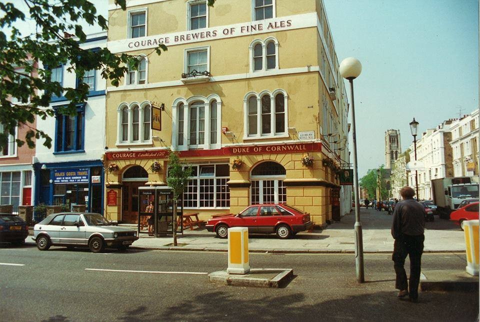
Duke of Cornwall, Ledbury Road W11, around 1990. Later the Ledbury restaurant, holder of two Michelin Stars
TUM image id:
1453282426
Licence:
St Peter's Notting Hill
Credit: Asteuartw
TUM image id:
1530106709
Licence: CC BY 2.0
Kensington Hippodrome, about 1840, showing St John’s Hill in the background.
TUM image id:
1455369279
Licence:
The Churchill Arms, Kensington
Credit: IG/lililondoner
TUM image id:
1653837477
Licence: CC BY 2.0
The Royal Oak pub in Bayswater gave its name to the nearby station
TUM image id:
1621895594
Licence:
SARM Studios, a recording studio, was established by Chris Blackwell, the founder of Island Records. They were originally known as Basing Street Studios. It has also been known in the past as Island Studios. SARM is an aconym of Sound and Recording Mobiles. At the studios, built inside a former church that had been deconsecrated, Blackwell recorded a number of artists there for Island Records, such as Iron Maiden, Bob Marley, Steve Winwood, Free, Bad Company, Robert Palmer, Jimmy Cliff, Nick Drake, Fairport Convention, King Crimson, John Martyn, Mott the Hoople, Quintessence, Roxy Music, Brian Eno, Sparks, Cat Stevens, Spooky Tooth, Traffic, If, Jethro Tull, the Average White Band, and the Sensational Alex Harvey Band.
TUM image id:
1453376699
Licence:
Abbotsbury Road, Holland Park (2008) These houses are just beside an entrance to Holland Park. Further along the road was the Maharishi Mahesh Yogi meditation centre visited by the Beatles in 1967.
Credit: Geograph/David Hawgood
TUM image id:
1623742620
Licence:
Arundel Gardens
Credit: Barbara Avis
TUM image id:
1453911014
Licence:
Boyne Terrace Mews, W11
TUM image id:
1453967964
Licence: CC BY 2.0
In the neighbourhood...
Click an image below for a better view...
Notting Hill
Licence: CC BY 2.0
Pembridge Road (1900s)
Licence: CC BY 2.0
St Peter's Notting Hill
Credit: Asteuartw
Licence: CC BY 2.0
The Churchill Arms, Kensington
Credit: IG/lililondoner
Licence: CC BY 2.0
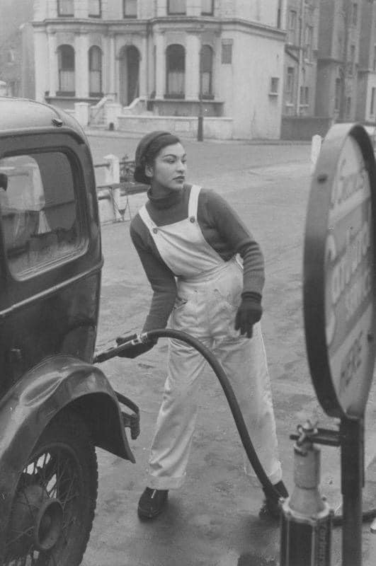
Pump attendant at a Lex Garage in Campden Hill Road, Kensington fills up for a customer (1952) In the 1950s, petrol pumps were still largely attached to garage workshops. People didn’t yet use the term “petrol station“ but instead “garage”.
Credit: Kurt Hutton/Picture Post
Licence:
3-4 Ladbroke Terrace in 2006.
Licence: CC BY 2.0
Notting Hill in Bygone Days
Licence:
This video is a little different - no walks from anywhere to anywhere. This video looks at the snapshots of lives captured by postcard photographers in Notting Hill Gate at the turn of the 1900s. As these photographers were ’winging it’ - taking photos of streets in anticipation of these being snapped up by postcard publishers - they were drawn to capturing scenes full of people going about their everyday lives. This means that zooming into these high-definition photos we can take a look at captured scenes that those depicted weren’t aware were being taken.
Credit: https://youtu.be/-Tqf2qTKTZM
Licence:
Ossington Street, W2 (2012)
Credit: Geograph/Jaggery
Licence: CC BY 2.0
Pembridge Gardens (1904)
Credit: rbkclocalstudies.wordpress.com/
Licence: