BT Tower, W1W

Block in/near Fitzrovia, existing between 1964 and now

 HOME  ·  ABOUT  ·  ARTICLE  ·  MARKERS OFF  ·  BLOG 
(51.521 -0.139, 51.521 -0.139) 
MAP YEAR:18001810182018301860190019502024 
Use the control in the top right of the map above to view this area on another historic map
 
Block · * · W1W ·
October
20
2021
The BT Tower is a communications tower, previously known as the GPO Tower, the Post Office Tower and the Telecom Tower.

The main tower structure is 177 metres high, with a further section of aerial rigging bringing the total height to 191 metres. The building was designed by the architects of the Ministry of Public Building and Works: Eric Bedford and G. R. Yeats.

The structure was commissioned by the General Post Office (GPO) and its primary purpose was to support the microwave aerials then used to carry telecommunications traffic from London to the rest of the country. It replaced a much shorter tower which had been built on the roof of the neighbouring Museum telephone exchange to provide a television link between London and Birmingham. The taller structure was required to protect the radio links’ line of sight against some of the tall buildings in London then in the planning stage.


Post Office Tower under construction
(click image to enlarge)


The narrow cylindrical shape was chosen because of the requirements of the communications aerials: the building shifts no more than 25 centimetres in high wind speeds. Initially, the first 16 floors were for technical equipment and power. Above that was a 35-metre section for the microwave aerials, and above that were six floors of suites, kitchens, technical equipment, a revolving restaurant on the 34th floor and finally a cantilevered steel lattice tower. To prevent heat build-up, the glass cladding was of a special tint. The construction cost was £2.5 million. As well as the revolving restaurant (The Top of the Tower and operated by Butlins), the tower used to host viewing galleries - almost an essential family day out in the 1960s - and a souvenir shop.

The tower was topped out on 15 July 1964, and officially opened by the then Prime Minister Harold Wilson on 8 October 1965. In its first year the Tower hosted nearly one million visitors and over 100 000 diners ate in the restaurant.

Due to its importance to the national communications network, information about the tower was designated an official secret. In 1978, the journalist Duncan Campbell was tried for collecting information about secret locations, and during the trial the judge ordered that the sites could not be identified by name; the Post Office Tower could only be referred to as ’Location 23’.

A bomb exploded in the roof of the men’s toilets at the Top of the Tower restaurant on 31 October 1971. Responsibility for the bomb was claimed both by the IRA and the Angry Brigade, an anarchist collective. The bomb resulted in the tower being largely closed to the general public and public access to the building ceased completely in 1981.


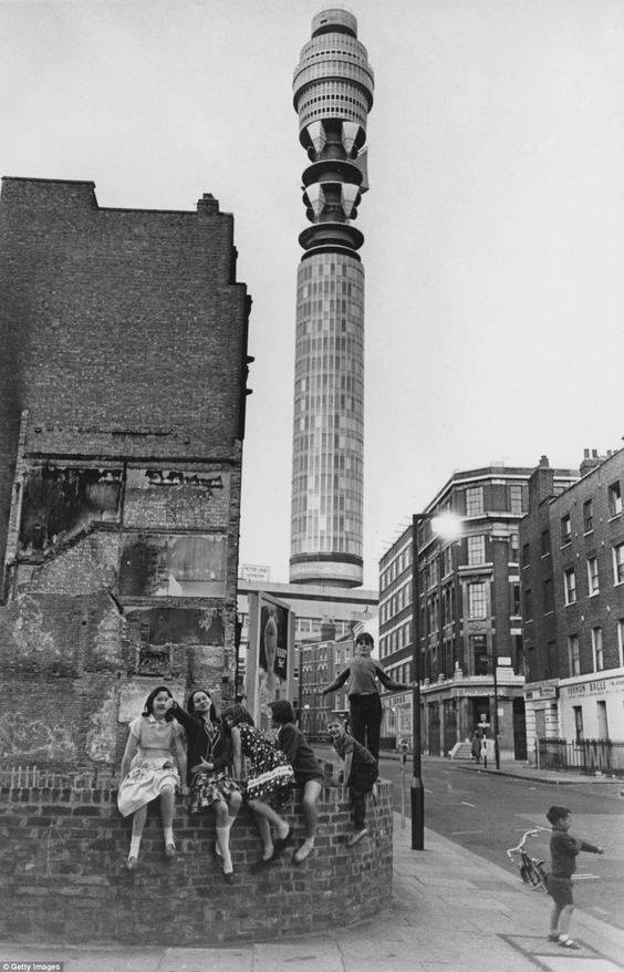
Youngsters play on the corner of Clipstone Street and Great Titchfield Street, in front of the Post Office Tower in 1965. Entry to the viewing gallery cost four shillings and was half price for children (Getty Images)
(click image to enlarge)


Upon completion the Post Office Tower overtook the Millbank Tower to become the tallest building in both London and the United Kingdom, titles it held until 1980, when it in turn was overtaken by the NatWest Tower.

The tower is still in use, and is the site of a major UK communications hub. Microwave links have been replaced by subterranean optical fibre links for most mainstream purposes, but the former are still in use at the tower. The second floor of the base of the tower contains the TV Network Switching Centre which carries broadcasting traffic and relays signals between television broadcasters, production companies, advertisers, international satellite services and uplink companies. The outside broadcast control is located above the former revolving restaurant.

A renovation in the early 2000s introduced a 360° coloured lighting display at the top of the tower. Seven colours were programmed to vary constantly at night and intended to appear as a rotating globe to reflect BT’s "connected world" corporate styling. The coloured lights give the tower a conspicuous presence on the London skyline at night.

In October 2009, a 360° full-colour LED-based display system was installed at the top of the tower, wrapped around the 36th and 37th floors. This comprises 529 750 LEDs arranged in 177 vertical strips, spaced around the tower.

In April 2019, the display spent almost a day displaying a Windows 7 error message.


Main source: Wikipedia
Further citations and sources


NEARBY LOCATIONS OF NOTE
All Souls Church All Souls Church is an evangelical Anglican church situated at the north end of Regent Street.
Fairyland During the period leading up to and during the First World War, 92 Tottenham Court Road was the location of a shooting range called Fairyland.
Great Portland Street Great Portland Street is a London Underground station near Regent’s Park.
Scala Theatre Scala Theatre was a theatre in London, sited on Charlotte Street, off Tottenham Court Road. The first theatre on the site opened in 1772, and was demolished in 1969, after being destroyed by fire.

NEARBY STREETS
Albany Terrace, NW1 Albany Terrace was named after Prince Frederick, Duke of York and Albany, brother of the Prince Regent (George IV) (Regent’s Park)
Alfred Mews, WC1E Alfred Mews is situated off Tottenham Court Road, running behind the gardens of North Crescent (Bloomsbury)
Alfred Place, WC1E Alfred Place was built in 1806 by a Marylebone stonemason called John Waddilove who named it after his son Alfred (Bloomsbury)
All Souls Place, W1B All Souls Place is a short cul-de-sac in the shadow of All Souls Church, originating in the eighteenth century as a mews off Edward Street (Fitzrovia)
Ambika House, W1B Ambika House is located on Portland Place (Oxford Circus)
Aradco House, W1T Aradco House is a block on Cleveland Street (Fitzrovia)
Arthur Stanley House, W1T Arthur Stanley House is located on Tottenham Street (Fitzrovia)
Arthur Tattersall House, WC1E Arthur Tattersall House is a block on Gower Street (Bloomsbury)
AWL House, W1W AWL House is a building on Great Portland Street (Fitzrovia)
Balfour House, W1W Balfour House is a block on Great Titchfield Street (Fitzrovia)
Bayley Street, WC1B Bayley Street is one of the streets of London in the WC1B postal area (Bloomsbury)
Belmont House, W1W Belmont House is a block on Candover Street (Fitzrovia)
Bentinck House, W1W Bentinck House is a block on Bolsover Street (Fitzrovia)
Berners Mews, W1T Berners Mews is one of the streets of London in the W1T postal area (Fitzrovia)
Bird Street, W1T Bird Street is one of the streets of London in the W1T postal area (Fitzrovia)
Bloomsbury House, WC1B Bloomsbury House is a block on Bedford Square (Bloomsbury)
Bolsover House, W1W Bolsover House is a building on Clipstone Street (Fitzrovia)
Bolsover Street, W1W Bolsover Street - home to the Royal National Orthopaedic Hospital since 1907 (Fitzrovia)
Bourlet Close, W1W Bourlet Close is one of the streets of London in the W1W postal area (Fitzrovia)
Broadcasting House, W1A Broadcasting House is a block on Portland Place (Fitzrovia)
Brock House, W1W Brock House is a building on Langham Street (Fitzrovia)
Bromley Place, W1T Bromley Place is one of the streets of London in the W1T postal area (Fitzrovia)
Brook House, WC1E Brook House is a block on Torrington Place (Bloomsbury)
BT Tower, W1W The BT Tower is a communications tower, previously known as the GPO Tower, the Post Office Tower and the Telecom Tower (Fitzrovia)
Byng Place, WC1E Byng Place is a road in the WC1E postcode area (Bloomsbury)
Bywell Place, W1W Bywell Place is one of the streets of London in the W1T postal area (Fitzrovia)
Candover Street, W1W Candover Street is one of the streets of London in the W1W postal area (Fitzrovia)
Capper Street, WC1E Capper Street is one of the streets of London in the WC1E postal area (Bloomsbury)
Carburton Street, W1W Carburton Street is one of the streets of London in the W1W postal area (Fitzrovia)
Cavendish Place, W1G Cavendish Place is one of the streets of London in the W1G postal area (Oxford Circus)
Chandos Street, W1G Chandos Street is one of the streets of London in the W1G postal area (Oxford Circus)
Charlotte Mews, W1T Charlotte Mews is one of the streets of London in the W1T postal area (Fitzrovia)
Charlotte Place, W1T Charlotte Place is one of the streets of London in the W1T postal area (Fitzrovia)
Charlotte Street, W1T Charlotte Street was laid out in the mid 18th century on open fields (Fitzrovia)
Chenies Mews, WC1E Chenies Mews is a road in the WC1E postcode area (Bloomsbury)
Chenies Street, WC1E Chenies Street takes its name from the Buckinghamshire village where since 1556 members of the Russell family have been buried. (Bloomsbury)
Chitty Street, W1T Chitty Street runs between Charlotte Street and Whitfield Street (Fitzrovia)
Cleveland Street, W1W Cleveland Street maybe dates from before 1632 when its name was recorded as Wrastling Lane. (Fitzrovia)
Clipstone Mews, W1T Clipstone Mews is a road in the W1T postcode area (Fitzrovia)
Clipstone Street, W1W Clipstone Street is one of the streets of London in the W1W postal area (Fitzrovia)
Coach Road, W1T Coach Road is a road in the NW1 postcode area (Bloomsbury)
Collingwood House, W1W Residential block (Fitzrovia)
Colville Place, W1T Colville Place is one of the streets of London in the W1T postal area (Tottenham Court Road)
Conway Mews, W1T Conway Mews is one of the streets of London in the W1T postal area (Fitzrovia)
Conway Street, W1T Conway Street runs from the Euston Road in the north to Fitzroy Square in the south (Fitzrovia)
Darwin Walk, WC1E Darwin Walk is a road in the WC1E postcode area (Bloomsbury)
De Walden Court, W1W De Walden Court is one of the streets of London in the W1W postal area (Fitzrovia)
Dean’s Mews, W1G This is a street in the W1G postcode area (Marylebone)
Devon House, W1W Devon House is a block on Great Portland Street (Great Portland Street)
Devonshire Close, W1G Devonshire Close is a road in the W1G postcode area (Marylebone)
Devonshire Row Mews, W1B Devonshire Row Mews is one of the streets of London in the W1W postal area (Marylebone)
Devonshire Street, W1W Devonshire Street is a road in the W1B postcode area (Great Portland Street)
Duchess House, W1T Duchess House is a block on Warren Street (Fitzrovia)
Duchess Mews, W1B Duchess Mews is one of the streets of London in the W1G postal area (Marylebone)
Duchess Street, W1B Duchess Street is a road in the W1B postcode area (Marylebone)
Duchess Street, W1W Duchess Street runs from Mansfield Street to Hallam Street, across Portland Place (Marylebone)
Elisa Court, W1T Elisa Court is a block on Chitty Street (Fitzrovia)
Evelyn House, W1W Evelyn House is a block on New Cavendish Street (Fitzrovia)
Fair Road, W1B Fair Road is one of the streets of London in the W1B postal area (Marylebone)
First Floor, W1T First Floor is one of the streets of London in the W1T postal area (Fitzrovia)
Fitzrovia Apartments, W1W Fitzrovia Apartments is a block on Bolsover Street (Fitzrovia)
Fitzrovia Court, W1 Fitzrovia Court is a block on Great Titchfield Street (Fitzrovia)
Fitzrovia House, W1T Fitzrovia House is a block on Cleveland Street (Fitzrovia)
Fitzroy Court, W1T Fitzroy Court is a road in the W1T postcode area (Fitzrovia)
Fitzroy Mews, W1T Fitzroy Mews is one of the streets of London in the W1T postal area (Fitzrovia)
Fitzroy Square, W1T Fitzroy Square is one of the Georgian squares of London (Fitzrovia)
Fitzroy Street, W1T Henry Fitzroy was an illegitimate son of Charles II and his mistress, Barbara Villiers - hence the family name Fitzroy: ‘King’s son’. (Fitzrovia)
Foley Street, W1W Foley Street is one of the streets of London in the W1W postal area (Fitzrovia)
Goodge Place, W1T Goodge Place is one of the streets of London in the W1T postal area (Fitzrovia)
Goodge Street, W1T Goodge Street was named after John Goodge a carpenter who along with his two nephews developed Crab Tree Fields to form Goodge Street in 1740 (Fitzrovia)
Goodwood Court, W1W Goodwood Court is a block on Devonshire Street (Great Portland Street)
Gordon Mansions, WC1E Gordon Mansions is one of the streets of London in the WC1E postal area (Bloomsbury)
Gosfield House, W1W Gosfield House is a building on Gosfield Street (Fitzrovia)
Gosfield Street, W1W Gosfield Street is one of the streets of London in the W1W postal area (Fitzrovia)
Gower Street, WC1E Gower Street is named after Gertrude Leveson-Gower, the wife of John Russell, the 4th Duke of Bedford (Bloomsbury)
GPS House, W1W GPS House is a block on Great Portland Street (Great Portland Street)
Grafton Mews, W1T Grafton Mews is one of the streets of London in the W1T postal area (Fitzrovia)
Grafton Way, W1T Grafton Way is one of the streets of London in the W1T postal area (Fitzrovia)
Grafton Way, WC1E Grafton Way was formerly Grafton Street (Bloomsbury)
Great Portland Street, W1W Great Portland Street forms the boundary between Fitzrovia to the east and, to the west, Marylebone. (Great Portland Street)
Great Titchfield Street, W1W Great Titchfield Street is one of the streets of London in the W1 postal area (Fitzrovia)
Greenwell Street, W1T Greenwell Street is a road in the W1T postcode area (Fitzrovia)
Greenwell Street, W1W Greenwell Street is one of the streets of London in the W1W postal area (Fitzrovia)
Gresse Street, W1T Gresse Street is one of the streets of London in the W1T postal area (Tottenham Court Road)
Hallam Street, W1W Hallam Street was formerly named both Charlotte Street and Duke Street but renamed in 1905 after Henry Hallam, a noted historian and local resident (Great Portland Street)
Hanson Street, W1W Hanson Street is one of the streets of London in the W1W postal area (Fitzrovia)
Harford House, W1W Harford House is a building on Great Portland Street (Fitzrovia)
Harmont House, W1G Residential block (Marylebone)
Henry Wood House, W1B Henry Wood House is a block on Langham Place (Fitzrovia)
Highwood House, W1W Highwood House can be found on New Cavendish Street (Fitzrovia)
Holcroft Court, W1W Holcroft Court is a block on Clipstone Street (Fitzrovia)
Howard House, W1T Howard House is a building on Cleveland Street (Fitzrovia)
Howland Street, W1T Howland Street is one of the streets of London in the W1T postal area (Fitzrovia)
Huntley Street, WC1E Huntley Street is one of the streets of London in the WC1E postal area (Bloomsbury)
James Boswell House, W1W James Boswell House is a block on Great Portland Street (Fitzrovia)
Julian House, W1T Julian House is a building on Windmill Street (Fitzrovia)
King Regent’s House, W1T King Regent’s House is a building on Fitzroy Street (Fitzrovia)
Kirkman House, W1T Kirkman House is a building on Whitfield Street (Tottenham Court Road)
Langham House, W1B Residential block (Oxford Circus)
Langham Place, W1B Langham Place is one of the streets of London in the W1B postal area (Oxford Circus)
Langham Street, W1W Langham Street is one of the streets of London in the W1W postal area (Fitzrovia)
Little Portland Street, W1W Little Portland Street is one of the streets of London in the W1W postal area (Fitzrovia)
Little Titchen Street, W1W Little Titchen Street is one of the streets of London in the W1W postal area (Fitzrovia)
Little Titchfield Street, W1W Little Titchfield Street is a road in the W1W postcode area (Fitzrovia)
Malet Place, WC1E Malet Place is a road in the WC1E postcode area (Bloomsbury)
Mansfield Street, W1G Mansfield Street connects New Cavendish Street and Queen Anne Street (Marylebone)
Maple Place, W1T Maple Place is a mews, previously called London Mews (Tottenham Court Road)
Maple Street, W1T Maple Street is one of the streets of London in the W1T postal area (Fitzrovia)
Maxclif House, W1T Maxclif House is a block on Tottenham Street (Tottenham Court Road)
Met Building, W1T Met Building is a block on Percy Street (Tottenham Court Road)
Middlesex House, W1T Middlesex House is sited on Cleveland Street (Fitzrovia)
Middleton Buildings, W1W Middleton Buildings is one of the streets of London in the W1W postal area (Fitzrovia)
Middleton Place, W1W Middleton Place is one of the streets of London in the W1W postal area (Fitzrovia)
Midford Place, W1T Midford Place is one of the streets of London in the W1T postal area (Tottenham Court Road)
Milford House, W1G Residential block (Marylebone)
Minehead House, W1W Minehead House is a building on Hanson Street (Fitzrovia)
Minerva House, WC1E Minerva House is a block on North Crescent (Bloomsbury)
Morley House, W1B Morley House is a block on Regent Street (Fitzrovia)
Morley House, W1W Residential block (Fitzrovia)
Mortimer Market, WC1E Mortimer Market is a road in the W1T postcode area (Bloomsbury)
Mortimer Street, W1T Mortimer Street is one of the streets of London in the W1T postal area (Fitzrovia)
Mortimer Street, W1T A street within the W1W postcode (Fitzrovia)
Mortimer Street, W1W Mortimer Street is one of the streets of London in the W1 postal area (Fitzrovia)
Morwell Street, WC1B Morwell Street is a road in the WC1B postcode area (Bloomsbury)
Mottram House, W1T Mottram House is located on Whitfield Street (Tottenham Court Road)
Nassau Street, W1T Nassau Street runs north from Mortimer Street (Fitzrovia)
Nelson House, W1G Nelson House is a block on New Cavendish Street (Marylebone)
Network Building, W1T Network Building is a block on Tottenham Court Road (Tottenham Court Road)
New Cavendish Street, W1B New Cavendish Street is one of the streets of London in the W1 postal area (Marylebone)
New Cavendish Street, W1W New Cavendish Street is one of the streets of London in the W1W postal area (Fitzrovia)
Newlands House, W1T Newlands House is sited on Berners Street (Fitzrovia)
Newman House, W1T Newman House can be found on Newman Street (Fitzrovia)
Newman Passage, W1T Newman Passage is one of the streets of London in the W1T postal area (Fitzrovia)
Newman Street, W1T Newman Street is one of the streets of London in the W1T postal area (Fitzrovia)
Nicolas Cooper House, WC1E Nicolas Cooper House is a block on Chenies Street (Bloomsbury)
North Crescent, WC1E North Crescent is one of the streets of London in the WC1E postal area (Bloomsbury)
Northumberland House, W1W Northumberland House is a block on Great Portland Street (Great Portland Street)
Ogle Street, W1W Ogle Street is one of the streets of London in the W1W postal area (Fitzrovia)
Orbis House, W1G Orbis House is located on Mansfield Street (Marylebone)
Osnaburgh Terrace, W1T Osnaburgh Terrace runs behind the (former) Holy Trinity Church (Regent’s Park)
Overland House, W1W Overland House can be found on Great Portland Street (Fitzrovia)
Park Crescent, W1B Park Crescent is one of the streets of London in the W1B postal area (Marylebone)
Park Square East, NW1 Park Square East lies north of Park Crescent and Marylebone Road (Regent’s Park)
Paul O’Gorman Building, WC1E Paul O’Gorman Building is a building on Huntley Street (Bloomsbury)
Percy Street, W1T Francis and William Goodge issued building leases for land on Percy Street’s south side in 1764 and north side in 1766. (Tottenham Court Road)
Peto Place, NW1 Peto Place is a road in the NW1 postcode area (Regent’s Park)
Phillips House, W1T Phillips House is a block on Goodge Street (Fitzrovia)
Portland Place, W1B Portland Place is one of the streets of London in the W1B postal area (Marylebone)
Putney House, W1 Putney House is a block on Great Titchfield Street (Fitzrovia)
Putney House, W1W Putney House is a block on Great Titchfield Street (Fitzrovia)
Queen Anne Mews, W1G Queen Anne Mews is one of the streets of London in the W1G postal area (Marylebone)
Queen’s Yard, W1T Queen’s Yard is a road in the W1T postcode area (Bloomsbury)
Rathbone Square, W1T Rathbone Square is a location in London (Tottenham Court Road)
Rathbone Street, W1T Rathbone Street is one of the streets of London in the W1T postal area (Fitzrovia)
Regent’s Place, W1T Regent’s Place is a walkway, series of blocks and a residential quarter (Regent’s Park)
Rembrandt House, W1W Rembrandt House is located on Great Portland Street (Fitzrovia)
Richardson’s Mews, W1T Richardson’s Mews runs off Warren Street (Fitzrovia)
Ridgmount Gardens, WC1E Ridgmount Gardens is one of the streets of London in the WC1E postal area (Bloomsbury)
Ridgmount Street, WC1E Ridgmount Street is one of the streets of London in the WC1E postal area (Bloomsbury)
Riding House Street, W1W Riding House Street commemorates a riding house and barracks of the First Troop of Horse Grenadier Guards (Fitzrovia)
Roberts Engineering Building, WC1E Roberts Engineering Building is sited on Torrington Place (Bloomsbury)
Salt Yard, W1T A street within the W1T postcode (Fitzrovia)
Scala Street, W1T Scala Street is named after the Scala theatre which formerly stood here (Goodge Street)
Shropshire House, WC1E Shropshire House is a block on Capper Street (Bloomsbury)
Sofia House, W1W Sofia House is a block on Devonshire Street (Fitzrovia)
South Cloisters, WC1H South Cloisters is a road in the WC1H postcode area (Bloomsbury)
Southampton Street, W1T Southampton Street absorbed Hampstead Street in 1885 before becoming Conway Street in 1938 (Fitzrovia)
St George’s House, W1T St George’s House is a block on Wells Street (Fitzrovia)
St Luke’s House, W1T St Luke’s House is a block on Fitzroy Square (Fitzrovia)
Stanhope House, W1T Stanhope House stood on the corner of Euston Road and Stanhope Street (Warren Street)
Stephen Mews, W1T Stephen Mews is one of the streets of London in the W1T postal area (Fitzrovia)
Stephen Street, W1T Stephen Street is one of the streets of London in the W1T postal area (Tottenham Court Road)
Store Street, WC1E Store Street is one of the streets of London in the WC1E postal area (Bloomsbury)
Tennyson House, W1W Tennyson House is a block on Great Portland Street (Great Portland Street)
The Cruciform Building, WC1E The Cruciform Building is a block on Gower Street (Bloomsbury)
The White House, W1W The White House can be found on Mortimer Street (Fitzrovia)
Third Floor, WC1E Third Floor is one of the streets of London in the WC1E postal area (Bloomsbury)
Threeways House, W1W Threeways House is a block on Clipstone Street (Fitzrovia)
Torrington Place, WC1E Torrington Place was developed by James Sim in partnership with his two sons (Bloomsbury)
Tottenham Court Road, W1T Tottenham Court Road is a major road running from the junction of Oxford Street and Charing Cross Road, north to Euston Road - a distance of about three-quarters of a mile (Tottenham Court Road)
Tottenham Mews, W1T Tottenham Mews is one of the streets of London in the W1T postal area (Fitzrovia)
Tottenham Street, W1T Tottenham Street is so-named as it is a turning out of Tottenham Court Road (Fitzrovia)
Triton Street, NW1 Triton Street is a road in the NW1 postcode area (Regent’s Park)
Union Street, W1W The easternmost section of Riding House Street was previously known as Union Street (Fitzrovia)
University Street, WC1E University Street is one of the streets of London in the WC1E postal area (Bloomsbury)
Walpole House, W1B Walpole House is a building on Weymouth Street (Marylebone)
Warren Court, NW1 Warren Court is a street in Camden Town (Tottenham Court Road)
Warren Court, W1T Warren Court is a block on Warren Street (Tottenham Court Road)
Warren Mews, W1T Warren Mews is a mews area situated off Warren Street (Fitzrovia)
Warren Street, W1T Warren Street was named after Anne Warren (1737–1807), the wife of Charles FitzRoy, landowner (Warren Street)
Wells Mews, W1W Wells Mews is one of the streets of London in the W1T postal area (Fitzrovia)
West One House, W1T West One House is a block on Wells Street (Fitzrovia)
West One House, W1W West One House is a block on Bourlet Close (Fitzrovia)
Weymouth Court, W1W Weymouth Court is a block on Weymouth Street (Great Portland Street)
Weymouth Mews, W1G Weymouth Mews is one of the streets of London in the W1G postal area (Marylebone)
Weymouth Street, W1B Weymouth Street is a road in the W1B postcode area (Marylebone)
Whitfield Place, W1T Whitfield Place is one of the streets of London in the W1T postal area (Fitzrovia)
Whitfield Street, W1T Whitfield Street runs from Warren Street in the north to Windmill Street in the south. (Fitzrovia)
Whitson Court, W1T Whitson Court is a block on Greenwell Street (Fitzrovia)
Willan House, W1T Willan House is a block on Fitzroy Square (Fitzrovia)
Windmill Street, W1T Windmill Street appears on the John Roque map from the 1750s (Tottenham Court Road)
Wogan House, W1A Wogan House is a block on Great Portland Street (Fitzrovia)
Woodford House, W1 Woodford House is a block on Great Titchfield Street (Fitzrovia)
York House, W1T York House is sited on Berners Street (Fitzrovia)


Click here to explore another London street
We now have 672 completed street histories and 46828 partial histories


Click here to see photos of the area


  Contact us · Copyright policy · Privacy policy

This page expires: Fri, 01 Nov 2024 15:37:06 GMT