The Highway, E1W

Road in/near Shadwell, existing until now

 HOME  ·  ARTICLE  ·  MAPS  ·  STREETS  ·  BLOG  ·  CONTACT US 
(51.50965 -0.05776, 51.509 -0.057) 
MAP YEAR:175018001810182018301860190019502023Show map without markers
ZOOM:14 15 16 17 14 15 16 17 14 15 16 17 14 15 16 17 14 15 16 17 14 15 16 17 14 15 16 17 18 14 15 16 17 14 15 16 17 18
TIP: Adjust the MAP YEAR and ZOOM to tweak historical maps
Road · Shadwell · E1W ·
November
30
2020

The Highway was once the Ratcliffe Highway.

In the early days of England’s rise to maritime power, when the foundations of the British Commonwealth were being laid by adventurous men whose courage made their own endeavours seem to themselves nothing but casual events in the life they lived, it was often said of the little vessels when they moored in the Lower Pool that they were "off Ratcliff."

Indeed they were, for the hamlet, which for several generations was the abode ashore of many fine seamen, once extended along the riverside westwards so far as to be separated from the Precinct of St. Katharine by the Tower only by Wapping Marsh, a watery waste consisting of 180 acres lying between the Hermitage and Foxes Lane. Towards the end of the sixteenth century, after much difficulty, it was effectually drained, and a new Wapping came into existence close behind the wall that embanked the Thames. The reclaimed land was recognised as being in the Hamlet of Wapping, or the Lower Hamlet of Whitechapel, in which parish it was included until 1694, when, by Act of Parliament, it was made a separate parish. The remaining part of old Wapping was, however, kept in the parish of Stepney, and for the sake of distinction called Wapping Stepney until 1729, when it became incorporated in the newly formed parish of St. George-in-the-East.

Long before this time the number of houses and the population of the hamlet of Ratcliff had increased. This was due principally to the building of Shadwell on the ground that lay between Foxes Lane and the part of Ratcliff known as the "town," which was so described to distinguish a particular locality (the business part) from the hamlet as a whole. The Vestry of Stepney decided in 1694 to make a boundary between the two places (Shadwell was not made a parish until 1669) and the dividing line at the riverside was by "the old baliste wharf," which is to-day Bell Wharf, Broad Street. Here was Cock Hill, which gently rose from the Thames, and the elevation being continued, Ratcliff Highway passed along it. The subsoil of this upland and the adjacent fields northwards was of gravel which, it is highly probable, belonged to the same deposit as that of the patch of light red gravel mentioned by Mr. A. G. Linney in his Lure and Lore of London River - as being visible to-day below the entrance to Millwall Dock at low water. To some it may be a pleasing thought that in the days of sail many tons of Ratcliff gravel soil were shipped as ballast, and being borne away came to be scattered over the face of the globe.

The town of Ratcliff from time immemorial extended along the strand or foreshore now represented by the length of Broad Street and part of Narrow Street. At its western extremity adjoining Bell Wharf there formerly existed a way down to the river. A painted notice on a board affixed to the wall at the entry declared its use to be a public right. The notice was put up by the old Limehouse Board of Works at the instance of some who were concerned in the past history of the neighbourhood, and believed that the spot marked on old maps as "the Lord’s waste," or common ground (indicating thereby its direct association with the manor) was identical with Stebenhythe, whence the name of Stepney was derived. The public right was extinguished by statute in 1922, when the space was taken into the Shadwell Park.

On the rising land at the back of Broad Street and parallel to it Brook Street came into existence. This was a paved way from the stream that flowed along the line of what is now Butcher Row. It is far from being a modern street, as it was mentioned in 1453, when Henry VI granted Garlek House, Brook Street, Stepney, to Sir Thomas Vaughan. Four years afterwards, on his surrender of it, the king re-granted it to him jointly with Jasper, Earl of Pembroke. This has been taken as an indication of the status of Ratcliff nearly 500 years ago, but, however much it may suggest that the house was desirable as a place of residence, the troubled times - the beginning of the War of the Roses - were not favourable to a settled life of ease and homely care. It is more likely that the premises, which may be located as being near to the way down to Ratcliff Cross, were used for official purposes in collecting the customs on wine, wool, skins and other merchandise which were unloaded from the little trading vessels on to the adjacent quays. Although a statute of 1480 provided that the King should not take the duties without consent of Parliament, he was at this period not only doing so, but was exacting increased customs by arrangement with the merchants. It is such matters on the fringe of parochial history that give it an added interest, and inquiries into their relation to the subject adds to knowledge, even it be only the mere linking of a local habitation and a name.

Until the reign of Elizabeth, when it was forbidden, the discharge of dutiable goods at Ratcliff went on uninterruptedly, and in times of outbreak of plague it was of great advantage to those engaged in the work, as well as to others who were employed in the various occupations associated with shipping and commerce. When the time had come for the landing of merchandise on the appointed quays higher up the river, the building, repairing and victualling of ships at Ratcliff had made considerable progress, and Ratcliff Cross was already a rallying-place for master mariners and their crews. From the Stairs nearby they went on board their ships wherever they might be in the Thames. In the neighbourhood abounded inns and taverns, and in those of the better sort a good deal of business was transacted with conviviality and profit.

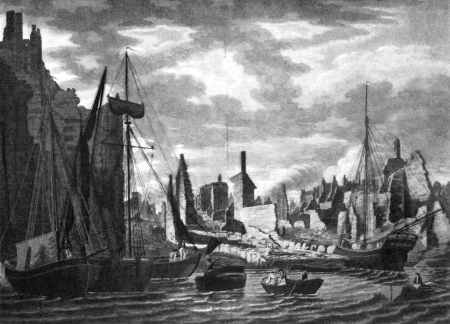
In 1794 a great fire destroyed most of Ratcliff in a few hours. An engraving entitled "The Ruins of Ratcliffe" shows the riverside. Some curiosity may be excited as to the appearance of the streets which were so quickly swept away. It is possible that a few of the houses were old timber-framed structures which had escaped previous lesser conflagrations. From time to time many had so perished of which there is no record. There was another fire in 1765, when between twenty and thirty old wooden houses were burnt and ten damaged, the loss being valued at £19,000, a remarkable sum, if true. In the eighteenth century many of the ancient properties had disappeared and commodious houses took their place, occupied by merchants, captains, and master craftsmen. The ease with which the great fire made its progress was principally due to the presence of a large number of wooden workshops and warehouses containing inflammable goods, and, of course, the difficulty of obtaining water. Of the buildings erected immediately afterwards, very few, if any, now remain to share the company of those which escaped disaster. In Narrow Street, near Ratcliff Cross Stairs, there is a house still standing that came into being in the days of Queen Anne. Altered in appearance by age and ill-treatment, it is less attractive than one or two houses in Stepney Causeway which were built some fifty years later. A good specimen of a house which was built about 1780 remains in Butcher Row. It was once the residence of a wealthy shipowner, and to it were attached extensive gardens. It is now St. James’s Vicarage, and is practically unchanged, and contains many features of interest, principal among them being the fine entrance. On the walls of the dining- and drawing-rooms are painted seascapes and Italian scenery. A little room - a powder closet - is a survival of the days when wigs were worn, and had to be occasionally dusted over.

A change which is occasioned by a catastrophe is amazing to contemporaries, but one which takes place over a series of years passes almost unnoticed, for few eyes see the full effect of the slow transformation. By the construction of Rotherhithe Tunnel (the approach to which passes under Broad Street) and the demolition of courts and alleys to make room for the extension of business premises and for the erection of blocks of dwellings, not only the aspect, but the character of the whole neighbourhood has been altered.


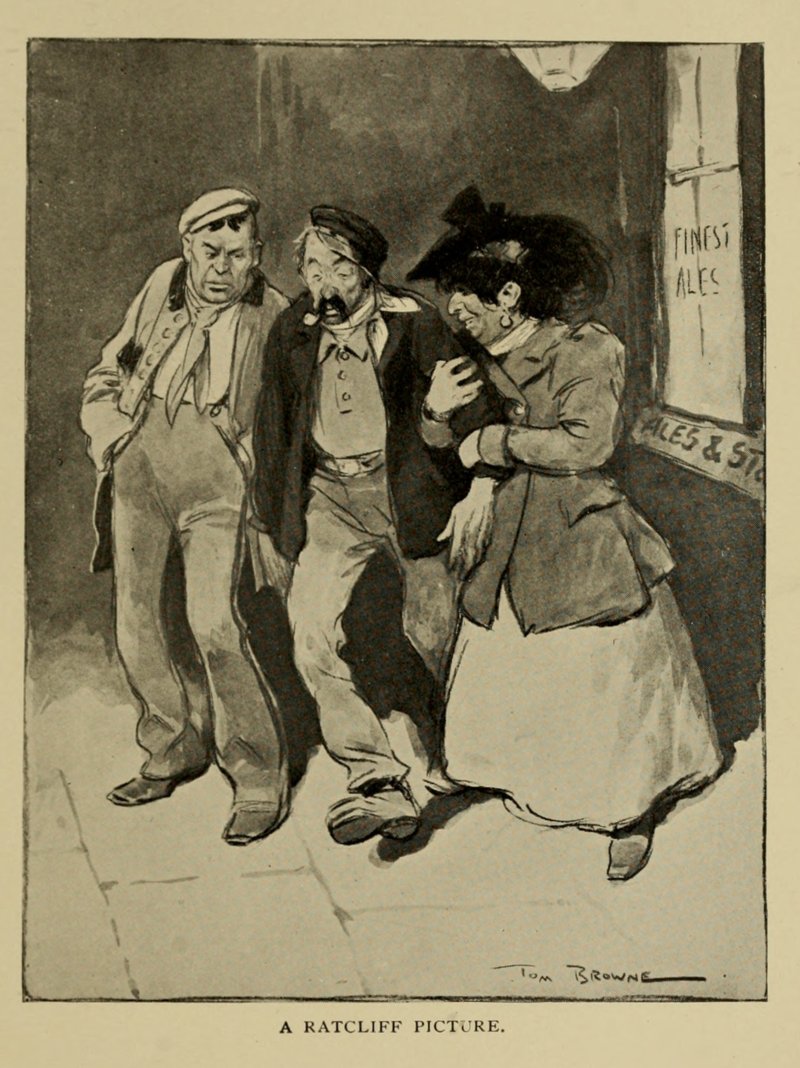
A Ratcliff Picture (1902). A low prostitute and her bully about to mug a sailor on a drunken spree (centre)
Tom Browne - The Night Side of London (1910)
(click image to enlarge)


There are some who can remember it as it was in the seventies of the last century: Broad Street with a bowsprite projecting across the road and almost touching the window of the house opposite the dry dock. The sight of the tall ship itself was enough to conjure up visions in a boy’s mind of pirates on the Spanish Main and pieces of eight. The street was redolent of odours strange and varied - hay, ship’s biscuits, coals, tarred twine, horses, brewers’ grains, paint, kippers, coffee, stale beer, and the mustiness of water-logged wood, all in sequence, but each individually blended with jam in the making. While the nose was enjoying the exercise of a generally much-neglected sense, the eyes peeped at the broad river, at the gap of Stone Stairs, or else through the arch at Free Trade Wharf. This arch has now gone, but the carved coat of arms of the East India Company which formerly surmounted it has happily been placed above the new entry, as a reminder of a great enterprise.

In Brook Street the courts and alleys - Harris Court, Hamlet Court, Blue Anchor Alley, etc., together with the houses that were built on the garden ground attached to Mr. Bere’s residence, which so "miraculously" was preserved from the flames, have all been demolished. Some of these were rebuilt soon after the Fire, and many of the occupants were employed in making the high-crowned beaver hats that were worn by gentlemen of fashion and of dignified deportment. The beaver left the hat industry and the silkworm took its place, and the old class of tenants vanished. The Irish came and took possession for many years of the houses which until then had been decently and tidily kept. They were a rough, hard-working, hard drinking (if they had the wherewithal) warm-hearted, hot-headed people, who had an objection to paying rent, and loved to have a shindy among themselves, with a constable or two to fortify the mixture. They did not beg but were delighted to receive, and they could in charming accents invoke a multitude of blessings on this slight provocation.

From this region of turbulence one could, in a few paces, come to the neat abode of silence and peace. At the corner of School house Lane was the Quakers’ meeting-house and burial-ground. The building, which was pulled down this summer, was erected in 1794, and a view of its interior in its latter days is shown below. The land was purchased in 1666, this part of the street being then rural, by Thomas Yoakley on behalf of the Society of Friends who were treated here by the authorities, as else where, with great intolerance. In 1670 Sir John Robinson, the then Governor of the Tower and a violent opponent and persecutor of the Friends, came with soldiers and seized sixty-one forms and two tables. Justice Rycroft attended and fined them and also tendered the oath of allegiance, and on their refusal to be sworn committed them to Newgate. Placid and undismayed amid these disturbances, the Friends, who numbered among them master mariners and others connected with nautical affairs, subsequently met amid the ruins of their meeting-house, were fined, and sent to prison. Among those who are interred in the little burial-ground is John Scott, the Quaker poet who died in 1788. His poetry was known to Dr. Johnson and to Sir Walter Scott, the latter alluding to him (Redgauntlet, Letter vii) as one "who constructed verses well approved of even in the world." John Scott, whose settled place of residence was at Amwell, every year spent some time occasionally at a house which he had at Ratcliff Cross. Inspired by the view of the river from Ratcliff he composed the subjoined verses - a scene that is very different, even allowing for poetic licence, from that of to-day.

Based on "The Copartnership Herald", Vol. V, no. 58 (December 1935) by Sydney Maddocks


Licence: Creative Commons Attribution-ShareAlike Licence


Click here to explore another London street
We now have 614 completed street histories and 46886 partial histories
Find streets or residential blocks within the M25 by clicking STREETS


CONTRIBUTIONS TO THE LOCALITY

Comment
Tricia   
Added: 27 Apr 2021 12:05 GMT   

St George in the East Church
This Church was opened in 1729, designed by Hawksmore. Inside destroyed by incendrie bomb 16th April 1941. Rebuilt inside and finished in 1964. The building remained open most of the time in a temporary prefab.

Reply

Graham O’Connell   
Added: 10 Apr 2021 10:24 GMT   

Lloyd & Sons, Tin Box Manufacturers (1859 - 1982)
A Lloyd & Sons occupied the wharf (now known as Lloyds Wharf, Mill Street) from the mid 19th Century to the late 20th Century. Best known for making tin boxes they also produced a range of things from petrol canisters to collecting tins. They won a notorious libel case in 1915 when a local councillor criticised the working conditions which, in fairness, weren’t great. There was a major fire here in 1929 but the company survived at least until 1982 and probably a year or two after that.

Reply

Michael Upham   
Added: 16 Jan 2023 21:16 GMT   

Bala Place, SE16
My grandfather was born at 2 Bala Place.

Reply
Born here
Beverly Sand   
Added: 3 Apr 2021 17:19 GMT   

Havering Street, E1
My mother was born at 48 Havering Street. That house no longer exists. It disappeared from the map by 1950. Family name Schneider, mother Ray and father Joe. Joe’s parents lived just up the road at 311 Cable Street

Reply
Born here
jack stevens   
Added: 26 Sep 2021 13:38 GMT   

Mothers birth place
Number 5 Whites Row which was built in around 1736 and still standing was the premises my now 93 year old mother was born in, her name at birth was Hilda Evelyne Shaw,

Reply
Lived here
margaret clark   
Added: 15 Oct 2021 22:23 GMT   

Margaret’s address when she married in 1938
^, Josepine House, Stepney is the address of my mother on her marriage certificate 1938. Her name was Margaret Irene Clark. Her father Basil Clark was a warehouse grocer.

Reply
Comment
Boo Horton    
Added: 31 May 2021 13:39 GMT   

Angel & Trumpet, Stepney Green
The Angel & Trumpet Public House in Stepney Green was run by my ancestors in the 1930’s. Unfortunately, it was a victim on WWII and was badly damaged and subsequently demolished. I have one photograph that I believe to bethe pub, but it doesn’t show much more that my Great Aunt cleaning the steps.

Reply
Comment
   
Added: 6 Nov 2021 15:03 GMT   

Old Nichol Street, E2
Information about my grandfather’s tobacconist shop

Reply

   
Added: 15 Jan 2023 09:49 GMT   

The Bombing of Nant Street WW2
My uncle with his young son and baby daughter were killed in the bombing of Nant Street in WW2. His wife had gone to be with her mother whilst the bombing of the area was taking place, and so survived. Cannot imagine how she felt when she returned to see her home flattened and to be told of the death of her husband and children.


Reply

Admin   
Added: 26 Aug 2022 15:19 GMT   

Bus makes a leap
A number 78 double-decker bus driven by Albert Gunter was forced to jump an accidentally opening Tower Bridge.

He was awarded a £10 bonus.

Reply

fariba   
Added: 28 Jun 2021 00:48 GMT   

Tower Bridge Business Complex, S
need for my coursework

Source: university

Reply
Comment
Martin Eaton    
Added: 14 Oct 2021 03:56 GMT   

Boundary Estate
Sunbury, Taplow House.

Reply
Comment
The Underground Map   
Added: 8 Mar 2021 15:05 GMT   

A plague on all your houses
Aldgate station is built directly on top of a vast plague pit, where thousands of bodies are apparently buried. No-one knows quite how many.

Reply
Lived here
Kim Johnson   
Added: 24 Jun 2021 19:17 GMT   

Limehouse Causeway (1908)
My great grandparents were the first to live in 15 Tomlins Terrace, then my grandparents and parents after marriage. I spent the first two years of my life there. My nan and her family lived at number 13 Tomlins Terrace. My maternal grandmother lived in Maroon house, Blount Street with my uncle. Nan, my mum and her brothers were bombed out three times during the war.

Reply
Lived here
Linda    
Added: 18 Feb 2021 22:03 GMT   

Pereira Street, E1
My grandfather Charles Suett lived in Periera Street & married a widowed neighbour there. They later moved to 33 Bullen House, Collingwood Street where my father was born.

Reply

LATEST LONDON-WIDE CONTRIBUTIONS TO THE PROJECT

Comment
Loraine Brocklehurst    
Added: 24 May 2023 14:00 GMT   

Holcombe Road, N17
I lived at 23Holcombe Rd. with my parents, Grandfather , Aunt and Uncle in 1954. My Aunt and Uncle lived there until it was demolished. I’m not sure what year that was as we emigrated to Canada.

Reply

Jen Williams   
Added: 20 May 2023 17:27 GMT   

Corfield Street, E2
My mother was born in 193 Corfield Street in 1920.Her father was a policeman.

Reply

sofia   
Added: 19 May 2023 08:57 GMT   

43 MELLITUS STREET
43 MELLITUS STREET

Reply

   
Added: 17 May 2023 11:50 GMT   

Milson Road (1908 - 1954)
My grandparents and great grandparents and great great grandparents the Manley family lived at 33 Milson Road from 1908 to 1935. My grandad was born at 33 Milson Road. His parents George and Grace had all four of their chidren there. When his father Edward died his mother moved to 67 Milson in 1935 Road and lived there until 1954 (records found so far, it may be longer). Before that they lived in the Porten Road. I wonder if there is anyone that used to know them? My grandad was Charles ’Ted’ Manley, his parents were called George and Grace and George’s parents were called Edward and Bessie. George worked in a garage and Edward was a hairdresser.

Reply
Lived here
   
Added: 16 Apr 2023 15:55 GMT   

Rendlesham Road, E5
I lived at 14 Rendlesham Road in the 1940s and 50s. The house belonged to my grandfather James Grosvenor who bought it in the 1920s for £200.I had a brother who lived in property until 1956 when he married. Local families were the paisleys, the Jenners and the family of Christopher Gable.

Reply
Comment
Sandra Field   
Added: 15 Apr 2023 16:15 GMT   

Removal Order
Removal order from Shoreditch to Holborn, Jane Emma Hall, Single, 21 Pregnant. Born about 21 years since in Masons place in the parish of St Lukes.

Source:
Sign up


Reply
Comment
Sue Germain   
Added: 10 Apr 2023 08:35 GMT   

Southwood Road, SE9
My great great grandfather lived in Time Villa, Southwood Rd around 1901. He owned several coffee houses in Whitechapel and in South London, including New Time Coffee House so either his house was named after the coffee house or vice versa.

Reply

David Gleeson   
Added: 7 Apr 2023 22:19 GMT   

MBE from Campbell Bunk (1897 - 1971)
Walter Smith born at 43 Campbell Bunk was awarded the MBE in january honours list in 1971. A local councillor for services to the public.

Reply


NEARBY LOCATIONS OF NOTE
Corner of Johns Hill and Pennington Street (1906) The corner of Johns Hill and Pennington Street, Wapping, December 1906.

NEARBY STREETS
Ada Marie Court, E1 Ada Marie Court is sited on James Voller Way.
Adam Meere House, E1 Adam Meere House is located on Tarling Street.
Agatha Close, E1W Agatha Close is a modern redevelopment.
Agatha Street, E1W St James’s Place, marked on 1860s mapping, was renamed as Agatha Street in 1897.
Agra Place, E1 Before 1890, Agra Place was named Smith’s Place.
All Saints Court, E1 All Saints Court is a block on Johnson Street.
Angel Mews, E1W A street within the E1 postcode
Anne Boleyn House, E1W Anne Boleyn House is a block on Pearl Street.
Artichoke Hill, E1W Artichoke Hill is a road in the E1W postcode area
Asher Way, E1W Asher Way is one of the streets of London in the E1W postal area.
Bailey Tower, E1 Bailey Tower is a block on Challoner Walk.
Balkan Walk, E1W Balkan Walk is one of the streets of London in the E1W postal area.
Batson House, E1 Batson House is a building on Fairclough Street.
Beadnell Court, E1 Beadnell Court is a block on Cable Street.
Bells Street, Bells Street is an old East End street.
Benson Quay, E1W Benson Quay is a road in the E1W postcode area
Berner Street, Lower Berner Street was called Berner Street after 1868.
Betts House, E1 Betts House is the oldest block on the St George’s Estate.
Betts House, E1W Betts House is a block on Mary Sambrook Children’s Centre.
Betts Street, E1W Betts Street was formerly a lengthy street in the area.
Bewley House, E1 Bewley House is a block on Bewley Street.
Bewley Street, E1 A street within the E1 postcode
Bicknell House, E1 Bicknell House is a block on Ellen Street.
Bigland Street, E1 Bigland Street leads east from Cannon Street Road.
Bill Faust House, E1 Bill Faust House is a block on Tarling Street.
Binnacle House, E1W Binnacle House is a building on Cobblestone Square.
Blakesley Street, Lower John Street was renamed to Blakesley Street, E1 in 1865.
Bluegate Field, E1 Bluegate Field was a poetic name used in the 18th century for a section of Cable Street.
Breezers Court, E1W Breezers Court is a block on The Highway.
Breezer’s Hill, E1W Breezer’s Hill is a short, narrow hill running between The Highway (formerly Ratcliffe Highway and St George Street) and Pennington Street.
Brinsley House, E1 Brinsley House is a block on Tarling Street.
Brokmer House, E1 Brokmer House can be found on Crowder Street.
Burlington Court, E1 Burlington Court is sited on Cable Street.
Burslem Street, E1 Burslem Street is one of the streets of London in the E1 postal area.
Burwell Close, E1 Burwell Close is a road in the E1 postcode area
Cannon Street Road, E1 Cannon Street Road runs south from Commercial Road.
Capstan Court, E1W Capstan Court can be found on Wapping Wall.
Caxton Apartments, E1 Caxton Apartments is a block on Cable Street.
Challoner Walk, E1 Challoner Walk is a location in London.
Chancery House, E1 Chancery House is a block on Lowood Street.
Chandler Street, E1W Chandler Street is a road in the E1W postcode area
Chapman Place, Chapman Place is an old East End street.
Chapman Street, E1 Chapman Street is one of the streets of London in the E1 postal area.
Chi Building, E1 Chi Building is located on Crowder Street.
Chigwell Hill, E1W Chigwell Hill is a road in the E1W postcode area
China Court, E1W China Court is a block on Asher Way.
Christian Street, E1 Christian Street is one of the streets of London in the E1 postal area.
Cobblestone Square, E1W A street within the E1W postcode
Compass House, E1W Compass House is a block on Raine Street.
Cordage House, E1W Cordage House is a block on Cobblestone Square.
Cork Square, E1W A street within the E1W postcode
Cornwall Street, E1 A street within the E1 postcode
Cowley Street, Cowley Street is an old East End street.
Crowder Street, E1 A street within the E1 postcode
Danvers House, E1 Danvers House is a block on Greatorex street.
Dean House, E1 Dean House is a block on Tarling Street.
Dean Street, Cross Street became Dean Street in 1865 (4777).
Deancross Street, E1 Deancross Street is one of the streets of London in the E1 postal area.
Dellow House, E1 Dellow House is a block on Dellow Street.
Dellow Street, E1 Dellow Street was once Blue Gate Fields.
Discovery Walk, E1W A street within the E1W postcode
Donovan House, E1W Donovan House is a block on Lukin Street.
Drewett House, E1 Drewett House can be found on Christian Street.
Dunch Street, E1 Dunch Street is a street in
Ellen Julia Court, E1 Ellen Julia Court is a block on James Voller Way.
Ellen Place, E1 Ellen Place existed until the twentieth century.
Ellis Court, E1 Ellis Court is a block on James Voller Way.
Eluna Apartments, E1W Eluna Apartments is a block on Wapping Lane.
Emery Way, E1W Emery Way is location of London.
Fabian House, E1 Fabian House is a block on Cannon Street Road.
Farthing Fields, E1W A street within the E1W postcode
Fisher House, E1 Fisher House is a block on Cable Street.
Foley House, E1 Foley House is a block on Tarling Street.
Fowey Close, E1W A street within the E1W postcode
Garamond Building, E1 Garamond Building is a block on Crowder Street.
Garnet House, E1W Garnet House is a block on Garnet Street.
Garnet Street, E1W Garnet Street is one of the streets of London in the E1W postal area.
Ginger Line Building, E1W Ginger Line Building is a block on The Highway.
Glamis Road, E1W Glamis Road is one of the streets of London in the E1W postal area.
Golding Street, E1 Golding Street is one of the streets of London in the E1 postal area.
Gordon House, E1W Gordon House is a block on Glamis Road.
Gosling House, E1W Gosling House is a block on Gosling House.
Hadfield House, E1 Hadfield House is a block on Ellen Street.
Halliday House, E1 Halliday House is a block on Stutfield Street.
Hannah Building, E1 Hannah Building is sited on Watney Street.
Harding Street, Harding Street is an old East End street.
Hardinge Lane, E1W Hardinge Lane is a road in the E1 postcode area
Hardinge Street, E1W Hardinge Street existed in the 1750s or before as St George’s Path.
Harkness House, E1 Harkness House is a building on Christian Street.
Harrison House, E1 Harrison House is a block on Challoner Walk.
Hatton House, E1 Hatton House is a block on Hindmarsh Close.
Hawksmoor Mews, E1 Hawksmoor Mews is one of the streets of London in the E1 postal area.
High Street Shadwell, E1W High Street Shadwell eventually became part of The Highway.
Hilliard House, E1W Hilliard House is sited on Prusom Street.
Hindmarsh Close, E1 A street within the E1 postcode
Hodgeson House, E1 Hodgeson House is sited on Christian Street.
James Voller Way, E1 A street within the E1 postcode
Jewel Square, E1W A street within the E1W postcode
John Rennie Walk, E1W A street within the E1W postcode
Johnson Street, E1 Johnson Street first appears as John Street on 1820s mapping, but not on 1810s maps.
Juniper Street, E1 Juniper Street is now simply a cul-de-sac
Keetons Road, E1W A street within the E1W postcode
Kennet Street, E1W Kennet Street is a road in the E1W postcode area
Kinder Street, E1 A street within the E1 postcode
Kindersley House, E1 Kindersley House is a block on Philchurch Street.
King Charles Terrace, E1W King Charles Terrace is one of the streets of London in the E1W postal area.
King David Lane, E1 King David Lane connects Cable Street with The Highway.
King Henry Terrace, E1W King Henry Terrace is one of the streets of London in the E1W postal area.
Kingsley Mews, E1W A street within the E1W postcode
Knock Fergus, E1 Knock Fergus was absorbed into Cable Street during the 1860s.
Labour in Vain Street, Labour in Vain Street is an old East End street.
Langdale Street, E1 Langdale Street is one of the streets of London in the E1 postal area.
Langmore House, E1 Langmore House is a block on Stutfield Street.
Leeward Court, E1W Leeward Court is a block on Asher Way.
Lowder House, E1W Lowder House is a block on Wapping Lane.
Lower Chapman Street, Lower Chapman Street is an old East End street.
Lowood House, E1 Lowood House is located on Bewley Street.
Lowood Street, E1 Lowood Street is a road in the E1 postcode area
Lucas Street, Lucas Street is an old East End street.
Luke House, E1 Luke House is located on Tillman Street.
Lukin Street, E1 Lukin Street is one of the streets of London in the E1 postal area.
Mace Close, E1W A street within the E1W postcode
Maddocks House, E1 Maddocks House is a block on Cable Street.
Malay House, E1W Malay House is a block on Prusom Street.
Marble Quay, E1W Marble Quay is one of the streets of London in the E1W postal area.
Market Hill, Market Hill is an old East End street.
Martha Street, E1 Martha Street is one of the streets of London in the E1 postal area.
Martineau Square, E1 A street within the E1 postcode
Martingale House, E1W Martingale House is a block on Raine Street.
Mary Ann Street, Mary Ann Street is an old East End street.
Maryann Street, E1 Maryann Street existed from the 1810s until after the Second World War.
Matilda Street, Matilda Street is an old East End street.
Maynards Quay, E1W Maynards Quay is one of the streets of London in the E1W postal area.
Meadowcroft Mews, E1 A street within the E1 postcode
Meeting House Alley, E1W Alley is a road in the E1W postcode area
Mercers Street, Mercers Street is an old East End street.
Merchant Court, E1W Merchant Court can be found on Wapping Wall.
Metropolitan Wharf, E1W Metropolitan Wharf is one of the streets of London in the E1W postal area.
Milk Yard, E1W Milk Yard is a road in the E1W postcode area
Montpelier Place, E1 Montpelier Place is a road in the E1 postcode area
Monza Building, E1W Monza Building is located on Monza Street.
Monza Street, E1W Monza Street lies south of the Shadwell Basin.
Moore House, E1W Moore House is a block on Martineau Street.
Morris Street, E1 Morris Street is a road in the E1 postcode area
Morton Close, E1 This is a street in the E1 postcode area
Mulberry Court, E1 Mulberry Court is a block on School Mews.
Mulberry Court, E1W A street within the E1 postcode
Neptune Street, Neptune Street is an old East End street.
Newlands Quay, E1W A street within the E1W postcode
Newton House, E1 Newton House is a block on Cornwall Street.
Noble Court, E1 Noble Court is a block on Cable Street.
Norton House, E1 Norton House is a block on Cannon Street Road.
Old Gravel, Old Gravel is an old East End street.
Orchid Apartments, E1 Orchid Apartments is a block on Crowder Street.
Oswell House, E1W Oswell House is a block on Farthing Fields.
Pace Place, E1 Pace Place is a road in the E1 postcode area
Park Vista Tower, E1W Park Vista Tower can be found on Cobblestone Square.
Peartree Lane, E1W Peartree Lane is a road in the E1W postcode area
Pegswood Court, E1 Pegswood Court is a block on Cable Street.
Pelican Stairs, E1W Pelican Stairs is a road in the E1W postcode area
Pell Street, Pell Street is an old East End street.
Penang House, E1W Penang House can be found on Prusom Street.
Penang Street, E1W Penang Street is a road in the E1W postcode area
Pennington Court, E1W Pennington Court is sited on The Highway.
Pennington Street, E1W Pennington Street is an east-west road in St George in the East, north of London Dock.
Philchurch Place, E1 Philchurch Place is one of the streets of London in the E1 postal area.
Pinchin Johnsons Yard, E1W Pinchin Johnsons Yard is one of the streets of London in the E1 postal area.
Pinchin Street, E1 Pinchin Street is one of the streets of London in the E1 postal area.
Ponler Street, E1 Ponler Street is a road in the E1 postcode area
Poonah Street, E1 Poonah Street first appears as a name in 1891.
Porters Walk, E1W Porters Walk is one of the streets of London in the E1W postal area.
Portland Square, E1W Portland Square is one of the streets of London in the E1W postal area.
President Drive, E1W A street within the E1W postcode
Princes Court Business Centre, E1W A street within the E1W postcode
Princes Court, E1W Princes Court is sited on Princes Court.
Princes Square, Princes Square is an old East End street.
Princes Street, E1 Tower Bridge Approach is one of the streets of London in the EC3N postal area.
Prince’s Square, E1W Prince’s Square was part of an eighteenth century Swedish community.
Prospecourt Place, E1W A street within the E1W postcode
Prospect Place, E1W Prospect Place is a road in the E1W postcode area
Providence Street, Providence Street is an old East End street.
Prusom Street, E1W Prusom Street is situated north of Wapping High Street.
Quantum Court, E1 Quantum Court is a block on King David Lane.
Queen Victoria Terrace, E1W Queen Victoria Terrace is one of the streets of London in the E1W postal area.
Queen’s Place, E1 Queen’s Place seems to have been a victim of the London Blitz.
Railway Arches, E1 Railway Arches is one of the streets of London in the E1 postal area.
Raine Street, E1W Raine Street is one of the streets of London in the E1W postal area.
Raine’s House, E1W Raine’s House is a block on Farthing Fields.
Reardon House, E1W Reardon House is a block on Reardon Street.
Reardon Street, E1W Reardon Street is one of the streets of London in the E1W postal area.
Redcastle Close, E1 Redcastle Close arrived with the construction of the Glamis Estate.
Richard Neale House, E1 Richard Neale House is a block on Cornwall Street.
Riverside Mansions, E1W Riverside Mansions is one of the streets of London in the E1W postal area.
Robert Sutton House, E1 Robert Sutton House is a block on Tarling Street.
Roding Mews, E1W A street within the E1W postcode
Rum Close, E1W A street within the E1W postcode
Sage Street, E1 This is a street in the E1 postcode area
Samuel Street, Samuel Street is an old East End street.
School Mews, E1 A street within the E1 postcode
Severn Street, Severn Street is an old East End street.
Severne Street, E1 Severne Street - also Severn Street - was a victim of the London Blitz.
Shadwell Gardens, E1 Shadwell Gardens serves the Shadwell Gardens Estate.
Shadwell Pierhead, E1W Shadwell Pierhead is one of the streets of London in the E1W postal area.
Shadwell Place, E1 Shadwell Place is a road in the E1 postcode area
Shead Court, E1 Shead Court is a block on James Voller Way.
Shearsmith House, E1 Shearsmith House is a building on Hindmarsh Close.
Sheridan Street, John Street was given the name Sheridan Street, E1 in 1864.
Ship Alley, E1W Ship Alley used to lie off Wellclose Square.
Smithfield Court, E1 Smithfield Court is located on Cable Street.
Solander Gardens, E1 A street within the E1 postcode
Sovereign Close, E1W Sovereign Close is one of the streets of London in the E1W postal area.
Spencer Street, Spencer Street is an old East End street.
Spencer Way, E1 A street within the E1 postcode
Spice Court, E1W Spice Court is a block on Asher Way.
Spirit Quay, E1W Spirit Quay is one of the streets of London in the E1W postal area.
St George Street, E1W Prior to the London County Council renaming programme of 1937, St George Street denoted part of the modern street called The Highway.
St Katharine By The Tower, E1W St Katharine By The Tower is one of the streets of London in the E1W postal area.
Stevedore Street, E1W A street within the E1W postcode
Stockholm House, E1 Stockholm House is a building on Swedenborg Gardens.
Stutfield Street, E1 Stutfield Street has existed since the early nineteenth century.
Sun Tavern Place, E1 Sun Tavern Place was not named directly after an inn but after Sun Tavern Fields, a ropewalk which it was built over.
Sun Walk, E1W Sun Walk is a road in the E1W postcode area
Sutton Street East, In Stepney E1, Church Road became Sutton Street East in 1862.
Sutton Street, E1 Sutton Street is one of the streets of London in the E1 postal area.
Swedenborg Gardens, E1 Swedenborg Gardens is a road in the E1 postcode area
Tait Street, E1 A street within the E1 postcode
Tamarind Yard, E1W A street within the E1W postcode
Tarbert Walk, E1 A street within the E1 postcode
Tarling Street, E1 Tarling Street is a road in the E1 postcode area
Telfords Yard, E1W Telfords Yard is one of the streets of London in the E1W postal area.
The Ship Apartments, E1 The Ship Apartments is a block on Hardinge Street.
Thornwill House, E1W Thornwill House is a building on Martineau Street.
Tillman Street, E1 A street within the E1 postcode
Tilman Street, Tilman Street is an old East End street.
Timberland Road, E1 Timberland Road is a road in the E1 postcode area
Topaz Court, E1W Topaz Court is a block on Elf Row.
Torrington Place, E1W A street within the E1W postcode
Trafalgar Court, E1W Trafalgar Court is a building on Wapping Wall.
Tulip Street, Tulip Street is an old East End street.
Turnour House, E1 Turnour House is a block on Walburgh Street.
Twine Court, E1 Twine Court is a road in the E1 postcode area
Upper Chapman Street, Upper Chapman Street is an old East End street.
Vinegar Street, E1W A street within the E1W postcode
Virginia Street, E1W Virginia Street is one of the streets of London in the E1W postal area.
Vogler House, E1W Vogler House is a block on Lukin Street.
Wainwright House, E1W Wainwright House is a block on Wine Close.
Walburgh Street, E1 A street within the E1 postcode
Walford House, E1 Walford House is a block on Estate Road.
Wapping Lane, E1W Wapping Lane is one of the streets of London in the E1W postal area.
Wapping Wall, E1W Wapping Wall runs parallel to the northern bank of the Thames with many converted warehouses facing the river.
Waterman Way, E1W Waterman Way is a road in the E1W postcode area
Watney Street, E1 Watney Street is the location for a famed East End street market.
Welland Mews, E1W A street within the E1W postcode
Wellington Terrace, E1W A street within the E1W postcode
Welstead House, E1 Welstead House is a block on Cannon Street Road.
West Gardens, E1W West Gardens is a road in the E1W postcode area
Whitehorn House, E1W Whitehorn House is sited on Prusom Street.
Wicker Street, E1 Wicker Street is a road in the E1 postcode area
Wilson Tower, E1 Wilson Tower is a block on Christian Street.
Wine Close, E1W Wine Close is a road in the E1W postcode area
Winterton House, E1 Winterton House is a block on Deancross Street.
Yule Court, E1 Yule Court was replaced by the Shadwell Gardens Estate during the 1970s.


Click here to explore another London street
We now have 606 completed street histories and 46894 partial histories


Shadwell

Shadwell is a district in the London Borough of Tower Hamlets, and located on the north bank of the Thames between Wapping and Ratcliff.

In the 13th century, the area was known as Scadflet and Shatfliet – derived from the Anglo-Saxon fleot, meaning a shallow creek or bay – the land was a low lying marsh, until drained (by order of Act of Parliament, after 1587) by Cornelius Vanderdelf. A spring, issuing from near the south wall of the churchyard was dedicated to St Chad, and filled a nearby well. The origin of the name is therefore confused, being associated with both the earlier use and the later well.

In the 17th century, Thomas Neale became a local landowner, and built a mill and established a waterworks on large ponds, left by the draining of the marsh. The area had been virtually uninhabited and he developed the waterfront, with houses behind as a speculation. Shadwell became a maritime hamlet with roperies, tanneries, breweries, wharves, smiths, and numerous taverns, built around the chapel of St Paul's. Seventy-five sea captains are buried in its churchyard; Captain James Cook had his son baptised there.

By the mid-eighteenth century, Shadwell Spa was established, producing sulphurous waters, in Sun Tavern fields. As well as medicinal purposes, salts were extracted from the waters; and used by local calicoprinters to fix their dyes.

In the 19th century, Shadwell was home to a large community of foreign South Asian lascar seamen, brought over from British India by the East India Company. There were also Anglo-Indians, from intermarriage and cohabitation between lascar seamen and local girls. There were also smaller communities of Chinese and Greek seamen, who also intermarried and cohabited with locals.

The modern area is dominated by the enclosed former dock, Shadwell Basin, whose construction destroyed much of the earlier settlement – by this time degenerated into slums. The basin once formed the eastern entrance to the then London Docks, with a channel leading west to St Katharine Docks. It is actually two dock basins - the south basin was constructed in 1828-32 and the north basin in 1854-8.

Unlike nearby Limehouse Basin, few craft larger than canoes can be seen on Shadwell Basin, which is largely used for fishing and watersports - and as a scenic backdrop to the modern residential developments that line it. The basin, however, is still connected to the Thames and the channel is spanned by a bascule bridge.

The original Shadwell station was one of the oldest on the network, and was built over a spring. First opened by the East London Railway on 10 April 1876, it was first served by the Metropolitan District Railway and Metropolitan Railway on 1 October 1884. It was renamed Shadwell & St. George-in-the-East on 1 July 1900 but reverted to its original name in 1918. In 1983, a new ticket hall was built on Cable Street, replacing the original building in Watney Street.

Shadwell DLR station opened on 31 August 1987 as part of the first tranche of DLR stations. Initially designed for one-car DLR trains, Shadwell's platform underwent extension to two-car operation in 1991. The station underwent further refurbishment in 2009, which extended the platforms to accommodate three-car trains, revamped the station entrance at ground level, and added an emergency exit at the east end of the platforms.

Shadwell station closed on 22 December 2007, reopened on 27 April 2010 for a preview service to New Cross and New Cross Gate, and from 23 May 2010, the latter service extended to West Croydon / Crystal Palace operated within the London Overground network.


LOCAL PHOTOS
Click here to see map view of nearby Creative Commons images
Click here to see Creative Commons images near to this postcode
Click here to see Creative Commons images tagged with this road (if applicable)
Thames Tunnel
TUM image id: 1554042170
Licence: CC BY 2.0

In the neighbourhood...

Click an image below for a better view...
Thames Tunnel
Licence: CC BY 2.0


One of the side roads leading from The Highway to Pennington Street. Possibly Artichoke Hill which is now much wider with new buildings on both sides.
Licence: CC BY 2.0


George Tavern (2015) Situated at 373 Commercial Road, the George Tavern’s building contains original brickwork some 700 years old, and is mentioned in texts by Geoffrey Chaucer, Samuel Pepys and Charles Dickens.
Credit: Wiki Commons/Jimmyketchup
Licence:


Cannon Street Road in the early 1940s
Licence:


Juniper Street is a turning off of King David Lane, E1 Before the Glamis Estate arrived on the scene in the 1970s and largely replaced it, Juniper Street was a road of densely packed terraces.
Licence:


The corner of Johns Hill and Pennington Street, Wapping, December 1906. The long range of late 17th century dwellings of Pennington Street stood directly opposite the towering walls and warehouses of London Docks, which they pre-dated - hence the raised level of road surface which provided access to the Docks. By the early twentieth century, many older buildings such as these, offered rooms and lodgings for the working poor, who are gathered here outside their houses.
Licence:


Settles Street, E1 (1940) This photo shows a fine old school sign which featured a torch. A direction sign to a Second World War shelter is on the wall.
Licence:


The pure joy of being a child, Fieldgate Mansions, Whitechapel (1970s)
Credit: David Hoffman
Licence:


St George’s Street (now part of The Highway) in 1896
Old London postcard
Licence: CC BY 2.0


Jackman House and its shops as seen from Old Gravel Lane. Photographed as part of the Wapping Housing Estate, ca. 1932
Licence:


Print-friendly version of this page

  Contact us · Copyright policy · Privacy policy