Westbourne Pond is marked on the 1830 Greenwood map as the source of the Westbourne River.
The hills of Hampstead Heath provide the source of three lost rivers of London - the Westbourne, Tyburn and Fleet. These rivers were long buried underground and the modern streetscape contains few hints at these former watercourses.
Old maps show the routes that these rivers took. The Westbourne rises in two main places in Hampstead and then flowed south through Kilburn, over to Paddington and Bayswater before feeding the Serpentine in Hyde Park. Southwards it flowed through Knighsbridge and Sloane Square, joining the River Thames at Chelsea.
Before it reaches Kilburn, the River Westbourne forms two tributaries - the Cannon Stream and the Kilbourne.
Cannon Stream

Hampstead Heath in 1840. (click image to enlarge)
Cannon Stream became the name for the west branch of the minor brooks which, once merged together at Kilburn, become the Westbourne.
The northernmost source of the Westbourne is
WHITESTONE POND
, which lies next to the highest point in the whole of north London (the highest point being these days occupied by a mobile phone tower). The pond was named after the white milestone marking the entrance to Hampstead, and its waters were once used to give military horses somewhere to drink.
From the pond the stream is imperceptible apart from during times of heavy rainfall but it runs to the southwest from Whitestone Pond. It takes a line parallel to, but to the north of Judges Walk.
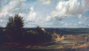
Hampstead Heath, with the House Called ‘The Salt Box’ - John Constable c.1819–20 (click image to enlarge)
BRANCH HILL POND
has now disappeared, but the Westbourne once flowed through it. The location of the pond can still be seen as a distinct hollow in the heath which is still grassland at this point. John Constable (1776-1837) painted an important oil of Branch Hill Pond.
The rivulet continues to flow southwest, under modern
Spedan Close
- when built in the 1970s, the most expensive council housing in the country and then follows the line of modern
Reddington Gardens
. Here it combines with two tributaries; one from Oak Hill and another from Telegraph Hill. It follows the line of
Heath Drive
before crossing under the Finchley Road where a very small dip in the road can still be ascertained.
Across the Finchley Road, Cannon Stream follows
Cannon Hill
downhill. The Cannon names are a 19th century derivation. Charles Cannon was a dye merchant who lived at Kidderpore Hall, West Hampstead converted an old footpath into Cannon Hill - it was this hill which lent its name to the stream. until it reached the rear of an old inn called the
COCK AND HOOP
and fed a
small pond on West End Green
.
Crossing
WEST END LANE
, Cannon Stream now flowed south through the fields which separated the boundary between what by the early nineteenth century were the Thorplands and Gilbert's Estate. It passed to the west of elevated ground in West Hampstead, under the modern
Solent Road
, crossing present-day
Sumatra Road
, crossing the two railways and then following the course of the length of
Kingsgate Road
until reaching Kilburn, where Cannon Stream joins two other rivulets to form the main river Westbourne.
Other roads that the Cannon Stream crossed on this route are
Holmdale Road
,
Narcissus Road
(which English Indie rock band The Hours, named an album after),
Liddle Road
,
Quex Road
,
Iverson Road
,
Maygrove Road
and
Birchington Road
.
Kilbourne
The second main feeder stream for the Westbourne was the Kilbourne, rising in a
pond
in the grounds of a former grand house called Frognal Hall in Hampstead. Both the old mansion and the pond have now disappeared but the pond lies underneath what is now 62 Frognal.
The stream was was originally called the Kilbourne - c
ye-burna (royal stream) or
cyna-burna (cow’s stream) - sometimes spelled
Kelebourne and gave its name to modern Kilburn.
Cuneburna as a name was first recorded in 1134.
Flowing south from the
pond
through a
field
, it continued beside
Frognal
before crossing the line of the modern
Hampstead Tunnel
.
At a point which at time of writing was the Langorf Hotel at 18 Frognal, it was
joined by a tiny tributary flowing from the east only a few hundred metres in length. The combined stream continues to follow Frognal and crosses
under the Finchley Road where Frognal meets the main road.
It flows under the modern
O2 Centre
and behind
Finchley Road tube station
before following a course west of the modern line of
Goldhurst Terrace
. At the time of the 1830 map of the area, there was a
pond
to the west - near to the junction of
Fairhazel Gardens
and
Greencroft Gardens
. On the way to this point, the Kilbourne crosses
Broadhurst Gardens
and
Canfield Gardens
. It also runs underneath the hidden glory that is
Compayne Open Space
.
Under the railway to the west of South Hampstead station and after crossing underneath
Belsize Road
, the stream roughly follows modern
Ainsworth Way
, following under the modern parkland estate to that road's north. Under
ABBEY ROAD
it flowed and then
Mortimer Crescent
and
Mortimer Place
, two roads with literary connections.

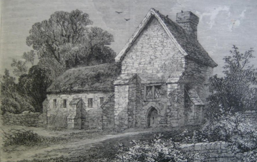
Kilburn Priory in 1750 (click image to enlarge)
The Kilbourne and Cannon Stream join together at
Kilburn Priory
, which dated from 1134 - the days of Henry I. The priory was situated where the Westbourne crossed at the present site of the junction of Kilburn High Road and Belsize Road. It had been constructed on the location of the cell of a hermit known as Godwyn and was home to the community of Augustinian canonesses.
The priory, was dedicated to the “Blessed Virgin Mary and St. John the Baptist”, became a renowned resting place for pilgrims stopping by on their way to St Albans. The river supplied the Priory’s moat and provided the inhabitants with water and fish until the dissolution of the monasteries in 1536 when the building was destroyed.
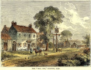
Priory lands incorporated a mansion and a guesthouse or hostium which may have constituted the basis of the Red Lion pub (believed to have been founded in 1444) and the
BELL INN
which found itself in due course next to a fashionable spring, opened in about 1600.
The water from this spring was then discovered to contain properties similar to Epsom Salts and gave rise to spas and pleasure gardens including the
KILBURN WELLS.
The two streams having combined, the story of the Westbourne proper continues underneath...
 The Westbourne
Once under the Edgware Road at the former
Kilburn Bridge
, the river has becomes the Westbourne. Until the river took this name in a back-formation from Westbourne Green (a place name which meant that it lay on the wet bank of a stream), it was called the Bayswater Rivulet. Whether Bayswater or Westbourne, it takes a somewhat circuitous route south...
Kilburn Bridge
, which was recorded in 1398 and thought to have been built in the mid 13th century by the prior of Kilburn, carried Edgware Road across the Kilburn brook (the Westbourne River). In 1826 the original stone bridge with a Gothic arch survived, flanked by brick portions added at two different periods. By that date repair was shared between the trustees of Marylebone turnpike and of the Kilburn Road. In more modern times, as the river has been culverted and sent underground, there is no trace of the structure.
Carlton Vale
links the Edgware Road to Kilburn Lane. In 1850 the Reverend Edward Stuart sold 47 acres to a consortium of five developers, of whom the largest was James Bailey. They laid out roads and sewers and divided the site among themselves, subletting to smaller firms who built a few houses each. Carlton Vale was originally called Carlton Road and was laid out over the former fields of
KILBURN BRIDGE FARM
. Several of the contractors aimed high with their early efforts but the isolated, muddy location - the vale being the flood plain of the Westbourne - failed to attract buyers and the estate remained incomplete for several decades. A new type of building, in red or multi-coloured brick, was used from the 1860s. It was soon to spread over the remaining unbuilt-upon land. Carlton Vale was extensively rebuilt after World War Two bombing.
Kilburn Park Road
was built along the course of the Bayswater Rivulet. Park Road, begun by 1855, was projected to run along the Willesden boundary - which ran along the stream - to meet the future Chippenham Road by 1861 and renamed Kilburn Park Road in 1862. Often straightened and culverted, as the Ranelagh sewer, before being built over, the Westbourne's course was still open (with its course straightened) in 1871 along the later line of both Kilburn Park Road and Shirland Road.
Shirland Road
. Now entering the W9 postcode, Shirland Road follows the course of the Westbourne as it turns sharply to the south east. There were houses on the west side of Shirland Road, at the south end, by 1870. The river then followed
Bristol Gardens
, W9 (13115). As late as 1857, Bristol Gardens still commanded uninterrupted country views to the north and west.

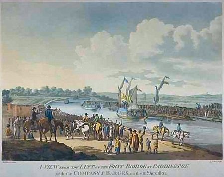
Opening day of the Kilburn Aqueduct (click image to enlarge)
One of the later curiosities of the Westbourne, is the
Kilburn Aqueduct
. When the Grand Union Canal was built at the turn of the nineteenth century, the valley of the River Westbourne ran through what were known as the Kilburn Fields. To span the valley, the new canal was placed on a 30 foot high embankment to cross the river. Development of the area after the canal was built was causing the Westbourne to become an open sewer. Around the early 1820s locals complained the awful smell emanating from the Westbourne. It was culverted for a considerable distance either side of the aqueduct by 1823. By the 1830s when the area was under development, especially with regards to the railway, the Westbourne had its course diverted and straightened out onto a parallel close to the southern end of Westbourne Terrace, and culverted beneath that road.
Now entering Paddington, the river crossed the modern
Bourne Terrace
, and
Westbourne Green
.
Harrow Road crossed the Westbourne at a place then called
Red Lion Bridge
. The Red Lion pub, a country pub beside the bridge, was moved 100 yards to the east when the first major change to the area came - the building of the Great Western Railway.
The Westbourne flowed south now to
Bishop's Bridge Road
. Westbourne Green was an early settlement and obliterated by mid 19th-century building, much of which consisted of streets with the prefix Westbourne and was sometimes known as Westbournia. From the southern end of the hamlet, a footpath later called Bishop’s Walk (eventually Bishop’s Bridge Road) provided a short cut to Paddington Green. The cutting of the GWR line across the middle of Westbourne Green was begun in 1836, necessitating a slight northward realignment of Harrow Road. Since the railway obstructed the Paddington Green end of Bishop’s Walk, the footpath was replaced by Bishop’s Road, soon extended westward as Westbourne Grove. Most of the area between Bishop’s Road and the railway had been filled by 1855. The renamed (after the Second War) Bishop’s Bridge Road became lined by many types of building.

Westbourne Terrace at the turn of the 20th century (click image to enlarge)
After crossing
Cleveland Gardens
, the Westbourne reaches
Cleveland Square
. During the Second World War the area around Paddington station sustained substantial damage due to the bombing of the city. Cleveland Square sustained two direct hits destroying houses numbers 8 to 11. Several other buildings in neighbouring streets were also destroyed. There was an anti-aircraft Barrage Balloon stationed in the gardens of Cleveland Square and until recently one of the flower beds still had the huge concrete block with steel attachments buried among the plants. This bed has been named the ‘Balloon Bed’ in tribute and there is a commemorative plaque positioned there. Cleveland Square, which once rivalled Lancaster Gate as the most expensive address in Bayswater, has an unusually large private garden to serve the massive range of six storeys and basements on its north side.
As the former river flows towards Hyde Park, two street names reflect their heritage:
Upbrook Mews
and
Brook Mews North
. (There was also originally a Brook Mews South)
Bayard’s Bridge
took the Uxbridge Road (now Bayswater Road) over the River Westbourne. The name Bayswater - the Westbourne River's original name - is said to have derived from ’Bayard’s Watering Place’, first recorded here in 1380, a ‘bayard’ being a horse which would have taken water from the river. Another explanation is that the land now called Bayswater belonged to the Abbey of Westminster when the Domesday Book was compiled; the most considerable tenant under the abbot was Bainiardus, may therefore be concluded that this ground known for its springs of excellent water, once supplied water to Baynard, his household, or his cattle; that the memory of his name was preserved in the neighbourhood for six centuries; and that his watering-place now takes the abbreviated name Bayswater.
As it crossed royal Hyde Park, the Westbourne originally formed eleven natural ponds. In 1730, Queen Caroline, wife of George II, asked for huge ornamental lake to be created. This became
The Serpentine
at the eastern end and the
Long Water
at the western. Originally the lake was fed by the River Westbourne entering at the Italian Garden at the north-western end of the Long Water. Queen Caroline, ordered the damming of the River Westbourne in Hyde Park as part of a general redevelopment of Hyde Park and Kensington Gardens. During the 1730s, the lake filled to its current size and shape. The redevelopment was carried out by Royal Gardener Charles Bridgeman, who dammed the Westbourne to create the artificial lake, and dug a large pond in the centre of Kensington Gardens (The Round Pond) to be a focal point for pathways in the park. At the time of construction, artificial lakes were typically long and straight. The Serpentine was one of the earliest artificial lakes designed to appear natural, and was widely imitated in parks and gardens nationwide. The Westbourne ceased to provide the water for the Serpentine in 1834, as the river had become polluted, and so water was then pumped from the Thames.
One of the hints of the former river lie in placenames - we have already seen Kilburn, Westbourne Green and Bayswater. The next one is
Knightsbridge
.
It is recorded that the citizens of London met Matilda of England at the Knight's Bridge in 1141. Knightsbridge is now home to many expensive shops, including the department stores Harrods and Harvey Nichols, and flagship stores of many British and international fashion houses, including those of London-based shoe designers Jimmy Choo and Manolo Blahnik, and two Prada stores. Some of London's most renowned restaurants are here, as well as many exclusive hair and beauty salons, antiques and antiquities dealers, and chic bars and clubs. But it has also been the scene of many riots. In 1556, at the time of Wyatt’s insurrection, the rebel and his followers arrived at the Knight's Bridge hamlet at nightfall, and stayed there all night before advancing on London.
The course of the Westbourne having crossed
William Mews, SW1
reaches
Lowndes Square
and
Lowndes Street
in Belgravia. Lowndes Square, a residential garden square, is home to some of the most expensive properties in the world. Roman Abramovich bought two stucco houses in Lowndes Square in 2008 worth £150 million, exceeding the value of the previous most expensive house in London and the UK, at £80 million. In 1824, Richard Grosvenor, 2nd Marquess of Westminster had commissioned the development of many buildings centred around Belgrave Square and Pimlico. The man he commissioned to develop this area was Thomas Cubitt, a builder from Norfolk and a partner, Seth Smith. Lowndes Street was developed from 1836 as part of the Cadogan Estate, also by Thomas Cubitt and Seth Smith. It was once part of the estate of William Lowndes of Chesham, after whom it is named.
Pont Street
(Bridge Street)
is a fashionable street in Knightsbridge/Belgravia. Pont Street is referred to in Evelyn Waugh’s novel Brideshead Revisited (1945), as a place related to typical English snobbery.
The bridge over the Westbourne at Sloane Square was called
Blandel Bridge
and was later renamed Grosvenor Bridge. It was about twelve or fourteen feet wide, and had walls on either side high enough to protect passengers from falling into the river. It was nicknamed “Bloody Bridge” going back as 1590 so named allegedly following the murder of Lord Harrington’s cook who was attacked and beaten to death by highwaymen. Bloody Bridge once comprised of a footbridge with a plank before a more substantial bridge, 16 feet wide and lined by high walls, was built in the reign of Charles ll.
Sloane Square
originally looked much the same as it does today, except that the square was an open green space enclosed by wooden posts, connected by iron chains. It was here that Queen Charlotte’s Royal Volunteers often assembled, and marched off in military order to Hyde Park, headed by their band. In the early 1980s, it lent its name to the
Sloane Rangers, the young underemployed and ostentatiously well-off members of the upper classes. Lady Diana Spencer, before she become Princess of Wales was considered the epitome of a Sloane Ranger.
Sloane Square station
was opened on 24 December 1868 by the Metropolitan District Railway when the company opened the first section of its line. The construction of the station was complicated by the crossing of the site by the River Westbourne. The river was carried above the platform in a large iron pipe suspended from girders. It remains in place today Meanwhile, Sloane Square itself lies at the east end of the trendy King's Road and at the south end of Sloane Street.
Lord Cadogan and the Chelsea vestry agreed in 1886 to reorganize the roads south of Sloane Square: Lower Sloane Street was widened, while Little George Street, Chelsea Market, Evans Cottages, Viner Place, George Place, and Woods Buildings, all east of Lower Sloane Street, were closed; Lower George Street was also closed and its upper end was replaced by the wider Sloane Gardens, linking into Lower Sloane Street. The straight
Holbein Place
replaced The Ditch, which had curved along the line of the Westbourne, and was linked to Lower Sloane Street by Holbein Mews.
The road from Westminster to Chelsea village was carried over the boundary by a stone bridge, documented from 1587 and it is probably the stone bridge which the vestry paid to mend in 1682. By the early 19th century a single-arch brick bridge in Grosvenor Row (later
Pimlico Road
) had replaced the stone one. There was an inn in Grosvenor Row called the "The Three Compasses," well known as a starting-point for the Pimlico omnibuses. It was generally known as the "Goat and Compasses"—possibly a corruption of the text, "God encompasseth us". The Chelsea Bun House in Grosvenor Row was the home of the Chelsea Bun but also had a museum of curiosities. The Bun House was run by several members of a family named Hand.

Ranelagh Gardens (click image to enlarge)
By now, we are entering Chelsea and meandering past
Ranelagh Grove
, the river reaches
Ebury Bridge Road
. Ebury Bridge itself spanned the Grosvenor Canal, not the Westbourne. For a while in the mid 19th century Ebury Bridge Road was called Commercial Road and it skirted the Chelsea Barracks - now a redevelopment site, The road, when laid out, originally lay next to the Westbourne as it turned a corner on its way to the River Thames.
Chelsea Bridge Road
was built in the 1850s to connect Chelsea with its bridge. Next to it, the Ranelagh pleasure gardens opened in 1742 to become one of the most fashionable pleasure resorts of the 18th century, with access by river as well as by road. In the 1760s Sir Thomas Robinson, one of the proprietors of the pleasure gardens, built a mansion east of the rotunda to his own designs called Prospect Place, where he lived until his death in 1777; by the 1790s the house had been divided. In 1803 the pleasure gardens closed and Ranelagh House, its Rotunda and other features were cleared. This part of the estate then became gardens in the ownership of the Hospital. In 1857-8 Chelsea Bridge Road was laid in a straight line from a widened White Lion Street to the new Chelsea Bridge, sweeping away the later Ranelagh House.
After passing through the modern Royal Hospital Grounds, a vestige of the river, a wide quay,
opens into the River Thames
some 270 metres west of Chelsea Bridge. An overflow outfall, from a pipe named the Ranelagh Sewer, can still be seen at low tide, as most of the Westbourne’s course has been used as a convenient depression in the land to place the local sewerage system, some of which takes surface water to form a combined sewer which links to two intercept sewers, the Middle Level Sewer and the Northern Low Level Sewer in the London sewerage system.
 | TIP: If you choose an historical map, an 'opacity' control will appear top right. Slide it to fade in the old map compared to a new map. |
Creative Commons Attribution-ShareAlike Licence