Wimbledon to Wimbledon Park walk

Traversing SW19

 HOME  ·  ARTICLE  ·  MAPS  ·  STREETS  ·  BLOG  ·  CONTACT US 
(51.422 -0.206, 51.422 -0.206) 
MAP YEAR:175018001810182018301860190019502023Show map without markers
ZOOM:14 15 16 17 14 15 16 17 14 15 16 17 14 15 16 17 14 15 16 17 14 15 16 17 14 15 16 17 18 14 15 16 17 14 15 16 17 18
TIP: Adjust the MAP YEAR and ZOOM to tweak historical maps
Article · Wimbledon · SW19 ·
MAY
13
2023

Traversing SW19

On this walk, I emerged at a side entrance to Wimbledon station beside the Centre Court shopping centre. Walking along the main road - Wimbledon Hill Road - takes you past the front entrance of Wimbledon station.

Wimbledon station serves as a transportation hub, accommodating National Rail, London Underground, and Tramlink services. Notably, it holds the distinction of being the sole station in London that facilitates transfers between the London Underground and Tramlink networks. The whole station was relocated to the northeast  for the opening of the District Railway in 1889.


The station was rebuilt with its current Portland stone entrance building by the Southern Railway in the late 1920s as part of the construction of their line to Sutton.

The artwork either side of the station in Concourse by Bruce Williams in 1998. It depicts photographic images of crowds at the Wimbledon Lawn Tennis Championships.

Wimbledon station also has an intriguing connection to a beloved canine figure known as the 'Railway Collection Dog.' Laddie, an Airedale Terrier, was born in September 1948 and began his duties at Wimbledon Station in 1949. Laddie's primary task was to collect donations on behalf of the Southern Railwaymen's Homes at Woking, carrying a collection box strapped to his back. His diligent efforts continued until his retirement in 1956, during which time he amassed an impressive sum of over £5000. After bidding farewell to his fundraising duties, Laddie spent the remainder of his days with the residents at the Home.

Following his passing in 1960, Laddie was preserved through taxidermy and returned to Wimbledon station, where he resided in a glass case on Platforms 7/8. Even in his stuffed form, he continued to fulfill his charitable role, collecting donations for the Homes. This display persisted until 1990, when Laddie retired once again, this time becoming a part of the National Railway Collection, cherished for his historical significance and connection to Wimbledon station.

Prior to 14 March 2011, the main entrance of Wimbledon station featured a roundabout designed to facilitate the convenient drop-off of passengers by vehicles. The presence of the roundabout resulted in a congested and constrained approach to the station, particularly during peak hours or periods of high activity.


Wimbledon station opened on a green field site - Wimbledon village was situated to its northwest. The station caused a lot of new development around its site so that the area became the main commercial focus of SW19.

Wimbledon Hill Road links the station with the village. Before we get that far, our walk takes a right at a road called Woodside.

Woodside dates from the 1890s with the growth of the neighbourhood connected to Wimbledon station. Continue up the road until gates appear at the foot of Lake Road.

Time now perhaps for a little history.

The earliest recorded development in the area dates back to 1588 when Thomas Cecil, Earl of Exeter, built a house on Home Park Road. The gardens of this property once housed a vineyard, a memory still reflected in the name Vineyard Hill Road. Subsequently, the neighbourhood became part of the Wimbledon Park estate, owned by the Duchess of Marlborough and later inherited by the Spencer family. Wimbledon Park House, the manor house of the estate built in 1801, was unfortunately demolished in 1949. Today, Ricards Lodge Secondary School occupies the site.

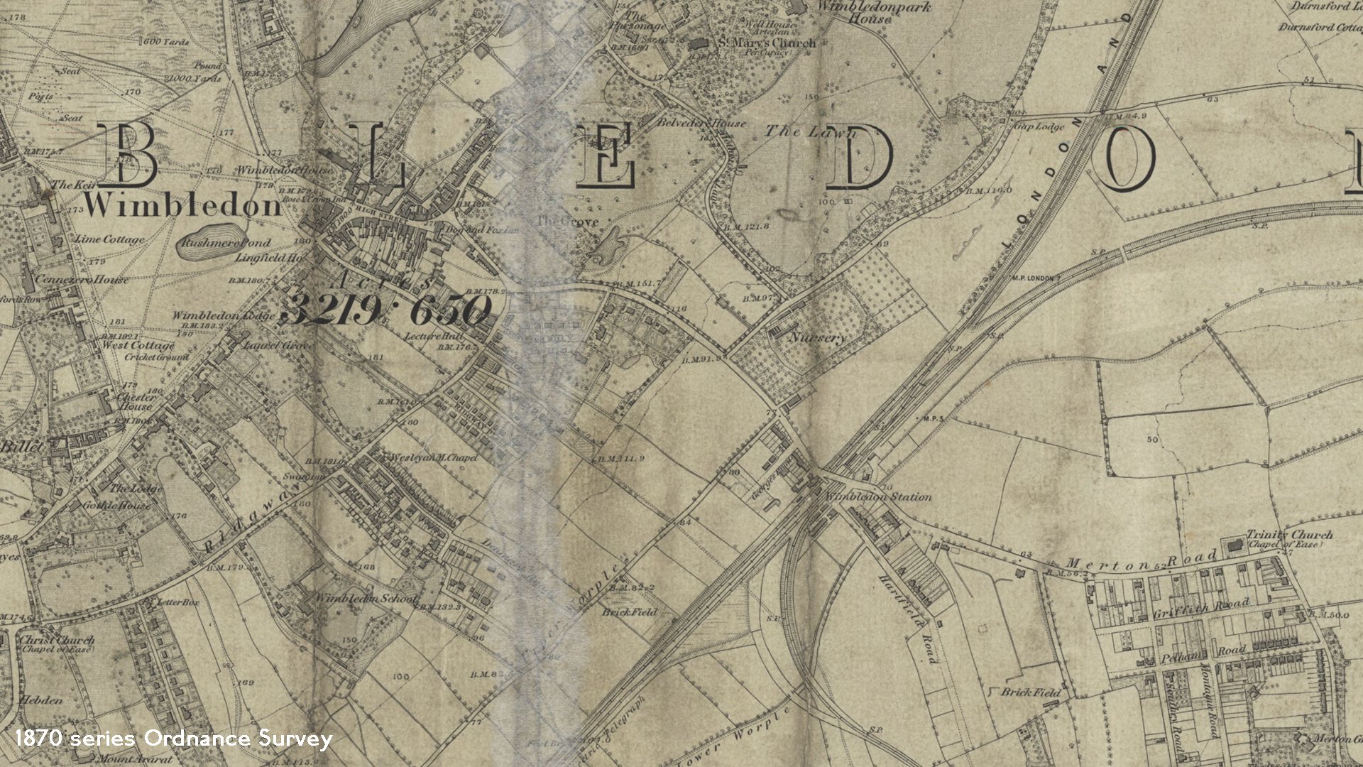
In 1764, Lord Spencer enlisted the renowned Capability Brown to landscape the estate. The 1865 Ordnance Survey maps depict Wimbledon Park House and its surrounding landscaped grounds. The South Western railway's main line reached Wimbledon in May 1838, and the area featured wooded areas such as Vineyard Hill Wood and Woodside.

John Augustus Beaumont later purchased the estate and transformed it into an affluent suburb in the late 19th and early 20th centuries. The streets of Lake Road, Arthur Road and Home Park Road, and were laid out in 1872.

Lake Road and the surrounding streets are now a charming Victorian suburb characterised by abundant foliage. Notable pillars adjacent to Queen Alexandra's Court marking its entrance. The railway line is running nearby, following Strathearn Road and Alexandra Road.

Queen Alexandra's Court - for which the gates were built - arrived in 1905. Further fine Victorina properties follow on our route.

By the late 1980s, infill development on demolished properties led to the development of Pine Grove which we pass. Lake Road continues with a long ascent

We cross the main road of the area - Leopold Road - and start to descend the largely 1890s-built Vineyard Hill Road. Development on Vineyard Hill Road initially progressed slowly.

The distant London skyline comes into view here. You can clearly make out iconic landmarks such as the London Eye, Battersea Power Station, Tower 42, and the Gherkin. Some of the magnificent houses here boast breath-taking vistas from their bedroom windows.

We take a left at the T junction with Home Park Road and follow it to Arthur Road.

Turn right here to find Wimbledon Park station.

Wimbledon Park station, nestled next to a bridge over the railway line, exudes a quaint and tranquil atmosphere, resembling a charming suburban cottage. The station was inaugurated on 3 June 1889 as a part of the Metropolitan District Railway's extension from Putney Bridge to Wimbledon. However, it is noteworthy that the actual construction of the lines was carried out by the London and South Western Railway, aiming to connect this area to Clapham Junction.


Licence: Creative Commons Attribution-ShareAlike Licence


Click here to explore another London street
We now have 618 completed street histories and 46882 partial histories
Find streets or residential blocks within the M25 by clicking STREETS


CONTRIBUTIONS TO THE LOCALITY

None so far :(
LATEST LONDON-WIDE CONTRIBUTIONS TO THE PROJECT


claudia s   
Added: 8 Jun 2023 13:57 GMT   

Drakewood Road, SW16
word

Reply
Comment
Loraine Brocklehurst    
Added: 24 May 2023 14:00 GMT   

Holcombe Road, N17
I lived at 23Holcombe Rd. with my parents, Grandfather , Aunt and Uncle in 1954. My Aunt and Uncle lived there until it was demolished. I’m not sure what year that was as we emigrated to Canada.

Reply

Jen Williams   
Added: 20 May 2023 17:27 GMT   

Corfield Street, E2
My mother was born in 193 Corfield Street in 1920.Her father was a policeman.

Reply

sofia   
Added: 19 May 2023 08:57 GMT   

43 MELLITUS STREET
43 MELLITUS STREET

Reply

   
Added: 17 May 2023 11:50 GMT   

Milson Road (1908 - 1954)
My grandparents and great grandparents and great great grandparents the Manley family lived at 33 Milson Road from 1908 to 1935. My grandad was born at 33 Milson Road. His parents George and Grace had all four of their chidren there. When his father Edward died his mother moved to 67 Milson in 1935 Road and lived there until 1954 (records found so far, it may be longer). Before that they lived in the Porten Road. I wonder if there is anyone that used to know them? My grandad was Charles ’Ted’ Manley, his parents were called George and Grace and George’s parents were called Edward and Bessie. George worked in a garage and Edward was a hairdresser.

Reply
Lived here
   
Added: 16 Apr 2023 15:55 GMT   

Rendlesham Road, E5
I lived at 14 Rendlesham Road in the 1940s and 50s. The house belonged to my grandfather James Grosvenor who bought it in the 1920s for £200.I had a brother who lived in property until 1956 when he married. Local families were the paisleys, the Jenners and the family of Christopher Gable.

Reply
Comment
Sandra Field   
Added: 15 Apr 2023 16:15 GMT   

Removal Order
Removal order from Shoreditch to Holborn, Jane Emma Hall, Single, 21 Pregnant. Born about 21 years since in Masons place in the parish of St Lukes.

Source:
Sign up


Reply
Comment
Sue Germain   
Added: 10 Apr 2023 08:35 GMT   

Southwood Road, SE9
My great great grandfather lived in Time Villa, Southwood Rd around 1901. He owned several coffee houses in Whitechapel and in South London, including New Time Coffee House so either his house was named after the coffee house or vice versa.

Reply


NEARBY LOCATIONS OF NOTE
New Wimbledon Theatre The New Wimbledon Theatre is a Grade II listed Edwardian theatre built by the theatre lover and entrepreneur, J B Mulholland.
Wimbledon Wimbledon is home to the Wimbledon Tennis Championships and New Wimbledon Theatre, and contains Wimbledon Common, one of the largest areas of common land in London.

NEARBY STREETS
Alexandra Mews, SW19 A street within the SW19 postcode
Alexandra Road, SW19 Alexandra Road is one of the streets of London in the SW19 postal area.
Alt Grove, SW19 Alt Grove is a road in the SW19 postcode area
Alwyne Road, SW19 Alwyne Road is one of the streets of London in the SW19 postal area.
Ash Court, SW19 Ash Court is a building on Worple Road.
Ashbourne Terrace, SW19 A street within the SW19 postcode
Ashcombe Road, SW19 Ashcombe Road is one of the streets of London in the SW19 postal area.
Ashville House, SW19 Ashville House is a block on The Broadway.
Barclays House, SW19 Barclays House is a block on Alexandra Road.
Barry House 20-22, SW19 Barry House is within the SW19 postcode.
Barry House, SW19 Barry House is located on Worple Road.
Beacon House, SW19 Beacon House is a block on Worple Road.
Belvedere Avenue, SW19 Belvedere Avenue is one of the streets of London in the SW19 postal area.
Belvedere Drive, SW19 Belvedere Drive is a road in the SW19 postcode area
Beulah Road, SW19 Beulah Road is one of the streets of London in the SW19 postal area.
Bradshaw Close, SW19 Bradshaw Close is one of the streets of London in the SW19 postal area.
Broadway Court, SW19 Broadway Court is a road in the SW19 postcode area
Broadway Place, SW19 Broadway Place is one of the streets of London in the SW19 postal area.
Brockham Close, SW19 Brockham Close is a road in the SW19 postcode area
Campden House, SW19 Campden House is a block on Worple Road.
Centre Court Shopping Centre, SW19 Centre Court Shopping Centre is one of the streets of London in the SW19 postal area.
Centre Street, SW19 Centre Street is one of the streets of London in the SW19 postal area.
Chabad House, SW19 Chabad House is a block on St George’s Road.
Chadwick Avenue, SW19 Chadwick Avenue is a road in the SW19 postcode area
Cobden Mew, SW19 A street within the SW19 postcode
Compton Road, SW19 Compton Road is one of the streets of London in the SW19 postal area.
Courthope Villas, SW19 Courthope Villas is a road in the SW19 postcode area
Drake House, Drake House is a block on St George’s Road
Drake House, SW19 Drake House is a block on St George’s Road.
Draxmont, SW19 Draxmont is a road in the SW19 postcode area
Dudley Road, SW19 Dudley Road is a road in the SW19 postcode area
Francis Grove, SW19 Francis Grove is one of the streets of London in the SW19 postal area.
Gladebury Court, SW19 A street within the SW19 postcode
Glendale Drive, SW19 Glendale Drive is a road in the SW19 postcode area
Grosvenor Court, SW19 Grosvenor Court is a road in the SW19 postcode area
Guild House 30-32, SW19 A street within the SW19 postcode
Guild House, SW19 Guild House can be found on Worple Road.
Hartfield Crescent, SW19 Hartfield Crescent is one of the streets of London in the SW19 postal area.
Hartfield Road, SW19 Hartfield Road is one of the streets of London in the SW19 postal area.
Hill Court, SW19 A street within the SW19 postcode
Hillborough Close, SW19 Hillborough Close is one of the streets of London in the SW19 postal area.
Holmes Place Club, SW19 Holmes Place Club is one of the streets of London in the SW19 postal area.
Integra House, SW19 Integra House is a block on Alexandra Road.
King’s Road, SW19 This is a street in the SW19 postcode area
Kings Road, SW19 Kings Road is one of the streets of London in the SW19 postal area.
Kingsridge, SW19 Kingsridge is one of the streets of London in the SW19 postal area.
Lake Close, SW19 A street within the SW19 postcode
Lake Road, SW19 Lake Road is a central road of a late Victorian development.
Leeward Gardens, SW19 Leeward Gardens is a road in the SW19 postcode area
Lismore, SW19 A street within the SW19 postcode
Malcolm Road, SW19 Malcolm Road is one of the streets of London in the SW19 postal area.
Mansel Road, SW19 Mansel Road is one of the streets of London in the SW19 postal area.
Park Court, SW19 A street within the SW19 postcode
Parkwood House, SW19 Parkwood House is sited on Parkwood Road.
Parkwood Road, SW19 Parkwood Road is a road in the SW19 postcode area
Pine Grove, SW19 Pine Grove dates from the late 1980s.
Princes Road, SW19 Princes Road is one of the streets of London in the SW19 postal area.
Printer’s Yard, SW19 A street within the SW19 postcode
Printers Yard 90a, SW19 A street within the SW19 postcode
Printers Yard, SW19 A street within the SW19 postcode
Queen Alexandra Court, SW19 Queen Alexandra Court is an Edwardian development of four blocks of 4 storey apartments in red brick.
Raymond Court, SW19 Raymond Court is one of the streets of London in the SW19 postal area.
Raymond Road, SW19 Raymond Road is one of the streets of London in the SW19 postal area.
Rose Court, SW19 A street within the SW19 postcode
Rostrevor Road, SW19 Rostrevor Road is a road in the SW19 postcode area
Roundacre, SW19 Roundacre is one of the streets of London in the SW19 postal area.
Rowan Court, SW19 Rowan Court is one of the streets of London in the SW19 postal area.
Salisbury Road, SW19 Salisbury Road is one of the streets of London in the SW19 postal area.
Satellite House, SW19 Satellite House is a block on Salisbury Road.
Shaw Court, SW19 A street within the SW19 postcode
Sir Cyril Black Way, SW19 Sir Cyril Black Way is a road in the SW19 postcode area
South Park Road, SW19 South Park Road is in Wimbledon.
Spencer Hill Road, SW19 Spencer Hill Road is one of the streets of London in the SW19 postal area.
Springfield Court, SW19 Springfield Court is a block on Springfield Road.
Springfield Road, SW19 Springfield Road is a road in the SW19 postcode area
St Georges House, SW19 St Georges House is a block on St Georges Road.
St Georges Road, SW19 St Georges Road is one of the streets of London in the SW19 postal area.
St Mark’s Place, SW19 St Mark’s Place leads up to St Mark’s Church.
St Marys Church Vicarage, SW19 St Marys Church Vicarage is one of the streets of London in the SW19 postal area.
St. George’s Road, SW19 St. George’s Road is a road in the SW19 postcode area
St.Mark’s Place, SW19 St.Mark’s Place is a road in the SW19 postcode area
Stanley Road, SW19 Stanley Road is one of the streets of London in the SW19 postal area.
Sunnyside Passage, SW19 Sunnyside Passage is a road in the SW19 postcode area
Tabor Grove, SW19 Tabor Grove is one of the streets of London in the SW19 postal area.
The Brambles, SW19 A street within the SW19 postcode
The Broadway, SW19 The Broadway is one of the streets of London in the SW19 postal area.
The Court House, SW19 The Court House is a block on Alexandra Road.
The Jubilee Centre, SW19 The Jubilee Centre is one of the streets of London in the SW19 postal area.
The Pavement, SW19 The Pavement is one of the streets of London in the SW19 postal area.
The Piazza, SW19 The Piazza is a road in the SW19 postcode area
Tuition House, SW19 Tuition House is a block on St Georges Road.
Westwood Court, SW19 A street within the SW19 postcode
William House, SW19 William House is sited on Worple Road.
Wimbledon Bridge House, SW19 Wimbledon Bridge House can be found on Wimbledon Bridge.
Wimbledon Bridge, SW19 Wimbledon Bridge is one of the streets of London in the SW19 postal area.
Wimbledon Hill Road, SW19 Wimbledon Hill Road connects Wimbledon station to Wimbledon village.
Wimbledon West Goods Yard, SW19 A street within the SW19 postcode
Windsor Park, SW19 Windsor Park is one of the streets of London in the SW19 postal area.
Woodside House, SW19 A street within the SW19 postcode
Woodside, SW19 Woodside dates from the 1890s within the growth of the neighbourhood near Wimbledon station.
Worcester Road, SW19 Worcester Road is one of the streets of London in the SW19 postal area.
Worple Court, SW19 Worple Court can be found on Worple Road.
Worple Road Mews, SW19 Worple Road Mews is one of the streets of London in the SW19 postal area.
York Court, SW19 York Court is one of the streets of London in the SW19 postal area.

NEARBY PUBS


Click here to explore another London street
We now have 613 completed street histories and 46887 partial histories


Wimbledon

Wimbledon is home to the Wimbledon Tennis Championships and New Wimbledon Theatre, and contains Wimbledon Common, one of the largest areas of common land in London.

The residential area is split into two sections known as the village and the town, with the High Street being part of the original medieval village, and the town being part of the modern development since the building of the railway station.

Wimbledon has been inhabited since at least the Iron Age when the hill fort on Wimbledon Common is thought to have been constructed. In 1087 when the Domesday Book was compiled, Wimbledon was part of the manor of Mortlake. The ownership of the manor of Wimbledon changed between various wealthy families many times during its history, and the area also attracted other wealthy families who built large houses such as Eagle House, Wimbledon House and Warren House. The village developed with a stable rural population coexisting alongside nobility and wealthy merchants from the city. In the 18th century the Dog and Fox public house became a stop on the stagecoach run from London to Portsmouth, then in 1838 the London and South Western Railway (L&SWR) opened a station to the south east of the village at the bottom of Wimbledon hill. The location of the station shifted the focus of the town’s subsequent growth away from the original village centre.

Wimbledon station is a National Rail, London Underground, and Tramlink station located in Wimbledon. The station serves as a junction for services from London Underground District Line and National Rail operators South West Trains, First Capital Connect and Tramlink Route 3.


LOCAL PHOTOS
Click here to see map view of nearby Creative Commons images
Click here to see Creative Commons images near to this postcode

In the neighbourhood...

Click an image below for a better view...
Dundonald Road tramstop signage and information board (2009)
Credit: Sunil Prasannan
Licence: CC BY 2.0


Print-friendly version of this page

  Contact us · Copyright policy · Privacy policy