Chepstow Villas, W11

Road in/near Notting Hill, existing between the 1850s and now.

 HOME  ·  ARTICLE  ·  MAPS  ·  STREETS  ·  BLOG  ·  CONTACT US 
(51.51322 -0.19934, 51.513 -0.199) 
MAP YEAR:175018001810182018301860190019502024Show map without markers
Use the control in the top right of the map above to view this area on another historic map
 
Road · * · W11 ·
JUNE
8
2015
Chepstow Villas is a road in W11 with a chequered history.

Chepstow Villas is a pleasant leafy street that runs between Pembridge Villas and Kensington Park Road. It is intersected by Ledbury Road/Chepstow Crescent; Denbury Road/Pembridge Crescent; and Portobello Road.

Until the 1840s, the whole area was agricultural land. But in around 1840 the demand for housing began to increase and the second great surge of housebuilding began on the Ladbroke estate. The Ladbroke family, the owners of the estate, had begun to sell off parcels of land to speculators. James Weller Ladbroke retained the eastern part of what is now Chepstow Villas (numbers 1-15 odds and 2-32 evens), but the central part, up as far as Portobello Road, passed into the ownership of Robert Hall of Old Bond Street. And after James Weller Ladbroke’s death in 1847, his heir Felix Ladbroke sold the western plot to a speculating parson from Bedfordshire, the Rev. Brooke Edward Bridges, and the latter then sold it on to another developer, Thomas Pocock. So there were a number of different landowners involved in the development of Chepstow Villas.

During the second half of the 1840s and the early 1850s, the street was laid out and development proceeded apace on all three parts of Chepstow Villas, as well as in neighbouring streets. The landowners signed agreements with a number of developers, who each undertook to build a certain number of houses. Many of the developers were professional builders, but there were also gentlemen and tradesmen interested in property speculation who then employed their own builders. Once the houses were built, the landowner would give 99-year leases of the houses to the developer in exchange for an annual ground rent. The developer would then sublet the individual houses in order to recover his investment. There are records of the dates on which the individual leases were granted, and from these one can work out when the houses were built. Although the landowners exercised some control over what houses were built, much was left to the individual developers, which explains the variety of styles to be found in the street.

One of the main developers, with whom both James Weller Ladbroke and Robert Hall signed agreements, was a civil engineer called William Henry Jenkins who hailed from Herefordshire on the Welsh borders. It was he who appears to decided the names for the new streets, choosing the names of places near his home – Chepstow, Denbigh, Ledbury and Pembridge.

The road started to decline around the turn of the twentieth century.

During the Blitz in the autumn of 1940, a number of bombs fell on Chepstow Villas, mostly causing only minor damage to roads and gardens. But an incendiary bomb on 15 October 1940 damaged the top floor of No. 46; and on 8 December 1940 Nos. 19 and 20 were damaged and two people had to be evacuated, according to air wardens’ reports.

In the 1960s and 1970s, Chepstow Villas began a steady ascent to renewed fashionability. An early sign came in the mid-1960s, when the Conservative MP Julian Critchley (1930-2000) moved into the detached villa at No. 50. He was shortly joined by his friend and fellow politician Michael Heseltine, who kept the house until the mid 1970s. By that time the street had become quite sought after, and Heseltine sold the house to a Saudi princess. She did not move in immediately, and the house (by then valued at some £200,000) became the subject of a famous squatting case. A group of squatters called “Mustard” or Multiracial union of Squatters to alleviate Racial Discrimination” moved into the house, announcing that they proposed to stay there until the owner was ready to move in. The Saudi princess finally obtained an eviction order in 1976.


Main source: Ladbroke Association
Further citations and sources


Click here to explore another London street
We now have 666 completed street histories and 46834 partial histories
Find streets or residential blocks within the M25 by clicking STREETS


CONTRIBUTIONS TO THE LOCALITY

Comment
EMC   
Added: 10 Jul 2023 22:35 GMT   

Ossington Street, W8
correcting the date on my existing comment

Source: Paddington: Bayswater | British History Online

Reply

Ken Herlingshaw   
Added: 17 Jun 2023 18:34 GMT   

St John the Evangelist - Spire
The top of the church spire fell off during WW2 (presumably during a bombing raid ?) and for many years after that the spire had a flat top.
I don’t know when it was restored.
Definitely not in the early fifties when I went to Sunday School there.

Reply
Comment
EMC   
Added: 10 Jul 2023 22:31 GMT   

Correction re Ossington Street
In the Wikipedia date of 1837 for the renaming of Victoria Grove as Ossington Street, the two last figures appear to have been transposed from the likely source, London County Council, Names of Streets (1905) quoted in T F T Baker, Diane K Bolton and Patricia E C Croot, ’Paddington: Bayswater’, in A History of the County of Middlesex: Volume 9, Hampstead, Paddington, ed. C R Elrington (London, 1989), pp. 204-212. British History Online ptth;:’www.british-history.ac.uk/vch/middx/vol9/pp204-212 [accessed 10 July 2023]. "During the 1830s Victoria Grove (renamed Ossington Street in 1873) (fn. 48) was laid out from the Uxbridge road close to the boundary, on part of Gravel Pit field." This makes sense, as John Evelyn Denison, a former Speaker of the House of Commons, was created 1st Viscount Ossington in 1873.

Source: Paddington: Bayswater | British History Online

Reply

LATEST LONDON-WIDE CONTRIBUTIONS TO THE PROJECT

Comment
Tony Whipple   
Added: 16 Apr 2024 21:35 GMT   

Frank Whipple Place, E14
Frank was my great-uncle, I’d often be ’babysat’ by Peggy while Nan and Dad went to the pub. Peggy was a marvel, so full of life. My Dad and Frank didn’t agree on most politics but everyone in the family is proud of him. A genuinely nice, knowledgable bloke. One of a kind.

Reply
Comment
Theresa Penney   
Added: 16 Apr 2024 18:08 GMT   

1 Whites Row
My 2 x great grandparents and his family lived here according to the 1841 census. They were Dutch Ashkenazi Jews born in Amsterdam at the beginning of the 19th century but all their children were born in Spitalfields.

Reply
Comment
Wendy    
Added: 22 Mar 2024 15:33 GMT   

Polygon Buildings
Following the demolition of the Polygon, and prior to the construction of Oakshott Court in 1974, 4 tenement type blocks of flats were built on the site at Clarendon Sq/Phoenix Rd called Polygon Buildings. These were primarily for people working for the Midland Railway and subsequently British Rail. My family lived for 5 years in Block C in the 1950s. It seems that very few photos exist of these buildings.

Reply

Steve   
Added: 19 Mar 2024 08:42 GMT   

Road construction and houses completed
New Charleville Circus road layout shown on Stanford’s Library Map Of London And Its Suburbs 1879 with access via West Hill only.

Plans showing street numbering were recorded in 1888 so we can concluded the houses in Charleville Circus were built by this date.

Source: Charleville Circus, Sydenham, London

Reply
Comment
Steve   
Added: 19 Mar 2024 08:04 GMT   

Charleville Circus, Sydenham: One Place Study (OPS)
One Place Study’s (OPS) are a recent innovation to research and record historical facts/events/people focused on a single place �’ building, street, town etc.

I have created an open access OPS of Charleville Circus on WikiTree that has over a million members across the globe working on a single family tree for everyone to enjoy, for free, forever.

Source: Charleville Circus, Sydenham, London

Reply
Comment
Charles   
Added: 8 Mar 2024 20:45 GMT   

My House
I want to know who lived in my house in the 1860’s.

Reply

NH   
Added: 7 Mar 2024 11:41 GMT   

Telephone House
Donald Hunter House, formerly Telephone House, was the BT Offices closed in 2000

Reply
Comment
Paul Cox   
Added: 5 Mar 2024 22:18 GMT   

War damage reinstatement plans of No’s 11 & 13 Aldine Street
Whilst clearing my elderly Mothers house of general detritus, I’ve come across original plans (one on acetate) of No’s 11 & 13 Aldine Street. Might they be of interest or should I just dispose of them? There are 4 copies seemingly from the one single acetate example. Seems a shame to just junk them as the level of detail is exquisite. No worries if of no interest, but thought I’d put it out there.

Reply


LOCAL PHOTOS
Click here to see map view of nearby Creative Commons images
Click here to see Creative Commons images near to this postcode
Click here to see Creative Commons images tagged with this road (if applicable)
Notting Hill
TUM image id: 1510169244
Licence: CC BY 2.0
Pembridge Road (1900s)
TUM image id: 1556889569
Licence: CC BY 2.0
Munro Mews, W10
TUM image id: 1453906723
Licence: CC BY 2.0

In the neighbourhood...

Click an image below for a better view...
Children of Ruston Close This road was the renaming of Rillington Place. Even after renaming, this street, where notorious murders had taken place, proved too much to avoid subsequent demolition.
Licence:


Notting Hill
Licence: CC BY 2.0


Pembridge Road (1900s)
Licence: CC BY 2.0


The Tabernacle is a Grade II*-listed building in Powis Square, W11 built in 1887 as a church. Photographed here in 2010.
Credit: Asteuartw
Licence: CC BY 2.0


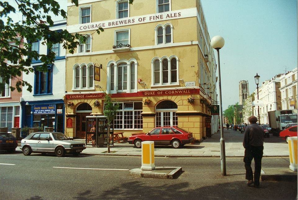
Duke of Cornwall, Ledbury Road W11, around 1990. Later the Ledbury restaurant, holder of two Michelin Stars
Licence:


St Peter's Notting Hill
Credit: Asteuartw
Licence: CC BY 2.0


Kensington Hippodrome, about 1840, showing St John’s Hill in the background.
Licence:


The Churchill Arms, Kensington
Credit: IG/lililondoner
Licence: CC BY 2.0


SARM Studios, a recording studio, was established by Chris Blackwell, the founder of Island Records. They were originally known as Basing Street Studios. It has also been known in the past as Island Studios. SARM is an aconym of Sound and Recording Mobiles. At the studios, built inside a former church that had been deconsecrated, Blackwell recorded a number of artists there for Island Records, such as Iron Maiden, Bob Marley, Steve Winwood, Free, Bad Company, Robert Palmer, Jimmy Cliff, Nick Drake, Fairport Convention, King Crimson, John Martyn, Mott the Hoople, Quintessence, Roxy Music, Brian Eno, Sparks, Cat Stevens, Spooky Tooth, Traffic, If, Jethro Tull, the Average White Band, and the Sensational Alex Harvey Band.
Licence:


Arundel Gardens
Credit: Barbara Avis
Licence:


  Contact us · Copyright policy · Privacy policy