Agar Town

Neighbourhood in/near St Pancras, existed between 1841 and 1868.

 HOME  ·  ARTICLE  ·  MAPS  ·  STREETS  ·  BLOG  ·  CONTACT US 
(51.53538 -0.12994, 51.535 -0.129) 
MAP YEAR:175018001810182018301860190019502024Show map without markers
TIP: To create your own sharable map, right click on the map
 
Neighbourhood · * · N1C ·
December
14
2020
Agar Town was a short-lived area, built in the 1840s, of St Pancras.

From 1789 the area was the private estate of William Agar of Elm Lodge. To contemporaries he was commonly called, ’Councillor Agar,’ and known as an eccentric and miserly lawyer. In the 1810s Agar fought a desperate battle to prevent the cutting of the Regent’s Canal through his property, although his underlying motive may simply have been to maximise the compensation he received.

William Agar died in 1838 and his widow soon began to grant building leases on part of the estate, while retaining Elm Lodge. The neighbourhood was started in 1841 with Agar’s widow leasing out small plots on the north side of the canal.

The 72 acre site was built of the lowest quality materials on 21 year leases. An area was a population of labourers living in houses they built for themselves, was generally considered a slum. Street names belied the type of area and included Canterbury Place, Durham Street, and Oxford Crescent.

The local vestry failed to provide “Ague Town”, as it became known, with street lighting or cleaning, there was no sewerage.

Charles Dickens described the area as "a suburban Connemara ... wretched hovels, the doors blocked up with mud, heaps of ash, oyster shells and decayed vegetables, the stench on a rainy morning is enough to knock down a bullock".

In 1851 one W M Thomas, a visitor to London, described his journey through the area: "The footpath, gradually narrowing, merged at length in the bog of the road. I hesitated; but to turn back was almost as dangerous as to go on. I thought, too, of the possibility of my wandering through the labyrinth of rows and crescents until I should be benighted; and the idea of a night in Agar Town, without a single lamp to guide my footsteps, emboldened me to proceed. Plunging at once into the mud, and hopping in the manner of a kangaroo — so as not to allow myself time to sink and disappear altogether — I found myself, at length, once more in the King’s Road".

Ownership passed to the Ecclesiastical Commissioners, who sold it to the Midland Railway "for a considerable sum". The church of St Thomas, Agar Town, was built on Wrotham Road in 1864, at the very time that the old town was disappearing beneath the tracks and goods yards that accompanied the opening of the Midland Railway’s St Pancras station.

"For its passenger station alone, the Midland Railway swept away a church and seven streets of three thousand houses," writes Mr. F. Williams, in his ’History of the Midland Railway: a Narrative of Modern Enterprise.’

"Old St. Pancras churchyard was invaded, and Agar Town almost demolished. Yet those who knew this district at that time have no regret at the change. Time was when the wealthy owner of a large estate had lived here in his mansion; but after his departure the place became a very ’abomination of desolation.’ In its centre was what was termed La Belle Isle, a dreary and unsavoury locality, abandoned to mountains of refuse from the metropolitan dust-bins, strewn with decaying vegetables and foul-smelling fragments of what once had been fish, or occupied by knackers’-yards and manure-making, bone-boiling, and soap-manufacturing works, and smoke-belching potteries and brick-kilns. At the broken doors of multilated houses canaries still sang, and dogs lay basking in the sun, as if to remind one of the vast colonies of bird-fanciers and dog-fanciers who formerly made Agar Town their abode; and from these dwellings came out wretched creatures in rags and dirt, and searched amid the far-extending refuse for the filthy treasure by the aid of which they eked out a miserable livelihood; whilst over the whole neighbourhood the gas-works poured forth their mephitic vapours, and the canal gave forth its rheumatic dampness, extracting in return some of the more poisonous ingredients in the atmosphere, and spreading them upon the surface of the water in a thick scum of various and ominous hues. Such was Agar Town before the Midland Railway came into the midst of it."

The displaced Agar Town inhabitants mostly moved to neighbouring districts like Kentish Town.

The name of Agar Town is commemorated by Agar Grove, a road that runs along the edge of where Agar Town used to be, and which was originally called St Paul’s Road. The Agar Grove estate was built in the mid-1960s. It originally consisted mostly of four storey blocks, plus the 19-storey Lulworth House.

After the goods yards became redundant, part of the site was opened as Camley Street natural park in 1984, while Fairview Estates developed Elm Village, a mix of social and private housing.
===================

Sources: Old and New London: Volume 5. Published by Cassell, Petter & Galpin (1878), Lost London by Richard Guard. Published by O’Mara Books (2012)


Main source: Old and New London
Further citations and sources


Click here to explore another London street
We now have 666 completed street histories and 46834 partial histories
Find streets or residential blocks within the M25 by clicking STREETS


CONTRIBUTIONS TO THE LOCALITY


Reg Carr   
Added: 10 Feb 2021 12:11 GMT   

Campbellite Meeting
In 1848 the Campbellites (Disciples of Christ) met in Elstree Street, where their congregation was presided over by a pastor named John Black. Their appointed evangelist at the time was called David King, who later became the Editor of the British Millennial Harbinger. The meeting room was visited in July 1848 by Dr John Thomas, who spoke there twice on his two-year ’mission’ to Britain.

Reply
Comment
Wendy    
Added: 22 Mar 2024 15:33 GMT   

Polygon Buildings
Following the demolition of the Polygon, and prior to the construction of Oakshott Court in 1974, 4 tenement type blocks of flats were built on the site at Clarendon Sq/Phoenix Rd called Polygon Buildings. These were primarily for people working for the Midland Railway and subsequently British Rail. My family lived for 5 years in Block C in the 1950s. It seems that very few photos exist of these buildings.

Reply
Reply
Neil   
Added: 31 Mar 2024 19:23 GMT   

The Polygon
My mum Pauline Quinn lived in the polygon buildings from 1940 to 1960.
She went to st. Aloysius school.


Reply
Reply
Neil   
Added: 31 Mar 2024 22:37 GMT   

The Polygon
My mum Pauline Quinn lived in the polygon buildings from 1940 to 1960.
She went to st. Aloysius school.


Reply

LATEST LONDON-WIDE CONTRIBUTIONS TO THE PROJECT

Comment
Tony Whipple   
Added: 16 Apr 2024 21:35 GMT   

Frank Whipple Place, E14
Frank was my great-uncle, I’d often be ’babysat’ by Peggy while Nan and Dad went to the pub. Peggy was a marvel, so full of life. My Dad and Frank didn’t agree on most politics but everyone in the family is proud of him. A genuinely nice, knowledgable bloke. One of a kind.

Reply
Comment
Theresa Penney   
Added: 16 Apr 2024 18:08 GMT   

1 Whites Row
My 2 x great grandparents and his family lived here according to the 1841 census. They were Dutch Ashkenazi Jews born in Amsterdam at the beginning of the 19th century but all their children were born in Spitalfields.

Reply
Comment
Wendy    
Added: 22 Mar 2024 15:33 GMT   

Polygon Buildings
Following the demolition of the Polygon, and prior to the construction of Oakshott Court in 1974, 4 tenement type blocks of flats were built on the site at Clarendon Sq/Phoenix Rd called Polygon Buildings. These were primarily for people working for the Midland Railway and subsequently British Rail. My family lived for 5 years in Block C in the 1950s. It seems that very few photos exist of these buildings.

Reply

Steve   
Added: 19 Mar 2024 08:42 GMT   

Road construction and houses completed
New Charleville Circus road layout shown on Stanford’s Library Map Of London And Its Suburbs 1879 with access via West Hill only.

Plans showing street numbering were recorded in 1888 so we can concluded the houses in Charleville Circus were built by this date.

Source: Charleville Circus, Sydenham, London

Reply
Comment
Steve   
Added: 19 Mar 2024 08:04 GMT   

Charleville Circus, Sydenham: One Place Study (OPS)
One Place Study’s (OPS) are a recent innovation to research and record historical facts/events/people focused on a single place �’ building, street, town etc.

I have created an open access OPS of Charleville Circus on WikiTree that has over a million members across the globe working on a single family tree for everyone to enjoy, for free, forever.

Source: Charleville Circus, Sydenham, London

Reply
Comment
Charles   
Added: 8 Mar 2024 20:45 GMT   

My House
I want to know who lived in my house in the 1860’s.

Reply

NH   
Added: 7 Mar 2024 11:41 GMT   

Telephone House
Donald Hunter House, formerly Telephone House, was the BT Offices closed in 2000

Reply
Comment
Paul Cox   
Added: 5 Mar 2024 22:18 GMT   

War damage reinstatement plans of No’s 11 & 13 Aldine Street
Whilst clearing my elderly Mothers house of general detritus, I’ve come across original plans (one on acetate) of No’s 11 & 13 Aldine Street. Might they be of interest or should I just dispose of them? There are 4 copies seemingly from the one single acetate example. Seems a shame to just junk them as the level of detail is exquisite. No worries if of no interest, but thought I’d put it out there.

Reply


LOCAL PHOTOS
Click here to see map view of nearby Creative Commons images
Click here to see Creative Commons images near to this postcode
The British Library
TUM image id: 1482066417
Licence: CC BY 2.0
The Carreras Cigarette factory, Mornington Crescent area This started life at the Acadia Works on City Road in the 19th century. It was a small business owned by Don Jose Carreras Ferrer who sold cigarettes, cigars and snuff out of small shops. A black cat began to curl up and sleep in the window of the shop near Leicester Square in Prince’s Street and the shop became known locally as "The Black Cat Shop". After the cigarette making machine was invented, the business required a large factory and moved to Hampstead Road between 1926 and 1928. It was designed by architect brothers, Marcus and Owen Collins with George Porri as their consultant. The black cat became the company’s logo. In 1959 the company merged with Rothmans and moved to Basildon, Essex. In the early 1960s the building became offices. The Egyptian décor was stripped away and the two cat statues removed. When the building got new owners in 1996, its former grandeur was restored. The building was later called “Greater London House” having become an office building.
TUM image id: 1660650534
Licence: CC BY 2.0
All Saints, Camden Town, in 1828.
TUM image id: 1492970567
Licence: CC BY 2.0
Cromer Street
TUM image id: 1547917827
Licence:
Goods Way - old sign
TUM image id: 1526241892
Licence: CC BY 2.0

In the neighbourhood...

Click an image below for a better view...
Kings Place from York Way
Credit: Alan Stanton
Licence: CC BY 2.0


The British Library
Licence: CC BY 2.0


Cobden Statue, corner of Eversholt Street and Camden High Street (1905) Richard Cobden (1804 - 1865) was a Radical and Liberal politician, manufacturer, and a campaigner for free trade and peace. He was associated with the Anti-Corn Law League and the Cobden–Chevalier Treaty. In 1866, the Cobden Club was founded to promote "Peace, Free Trade and Goodwill Among Nations".
Old London postcard
Licence:


Goods Way - old sign
Licence: CC BY 2.0


The Brill Market in Somers Town (1858) Centre stage in this engraving of a busy market scene is the Brill Tavern itself, situated at the end of Brill Row.
Credit: Illustrated News of the World, London
Licence:


York Road was the name for a ’lost’ underground station on the Piccadilly Line north of King’s Cross and south of Caledonian Road. Traffic levels were never high, and the station closed in 1932, on the same day that the northern extension of the Piccadilly Line from Finsbury Park to Arnos Grove opened. London Transport Museum runs tours of the station through its "Hidden London" programme. The tour features original elements of the station including the tiled lift lobby and signal cabin and it explores the modifications that were made to the station over the years. The road it was named after has also changed its name (to York Way)
Credit: The Underground Map
Licence:


The Polygon, Somers Town in 1850 The Polygon was an eighteenth century housing estate - a Georgian building with 15 sides and three storeys that contained 32 houses. The idea appears to have initially appealed to the middle-classes. Two of the most famous residents of the Polygon were William Godwin and his wife Mary Wollstonecraft, who died giving birth to Mary Shelley, the author of Frankenstein. Another former Polygoner was Charles Dickens, who lived at No 17 in the 1820s shortly after his father, John Dickens, was released from debtors prison. Dickens later made the Polygon a home for his ’Bleak House’ character Harold Skimpole.
Licence:


St Pancras Old Church claims to be one of the oldest sites of Christian worship in the world.
Credit: Wiki Commons
Licence: CC BY 2.0


St. James Gardens
Credit: Google
Licence: CC BY 2.0


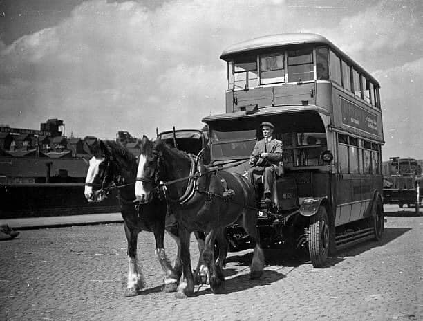
An old London bus being drawn by horses on its way to St Pancras Goods Station (1937) Next, its roof will be removed to enable it to fit on a railway trolley and then it will be transported to Chesterfield, Derbyshire for breaking up.
Licence:


  Contact us · Copyright policy · Privacy policy