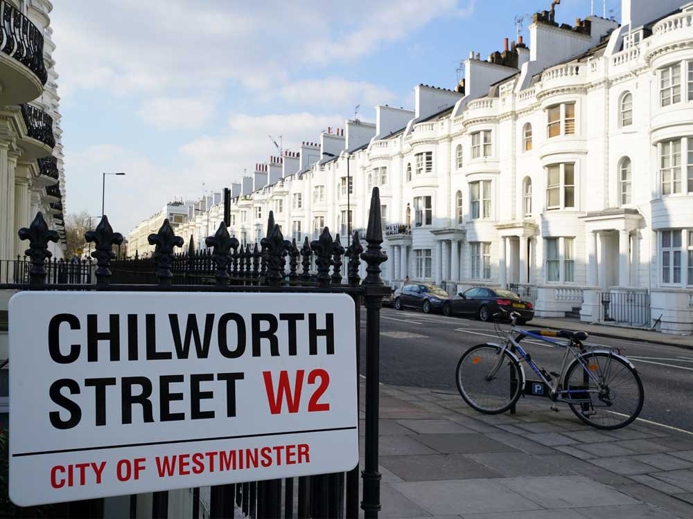
The Colonnades, W2
| The Colonnades, W2 |
| HOME | · | ARTICLE | · | MAPS | · | STREETS | · | BLOG | · | CONTACT US |
| MAP YEAR: | 1750 | 1800 | 1810 | 1820 | 1830 | 1860 | 1900 | 1950 | 2024 | Show map without markers |
| Use the control in the top right of the map above to view this area on another historic map | ||||||||||
| Main source: | A History of the County of Middlesex | British History Online |
| Further citations and sources |
| Click here to explore another London street We now have 666 completed street histories and 46834 partial histories Find streets or residential blocks within the M25 by clicking STREETS |
| CONTRIBUTIONS TO THE LOCALITY |
  Added: 22 Aug 2023 12:31 GMT | Hampden Street, W2 My great great grandparents William and Hannah Playford lived at 60 Hampden Street from the mid 1880s when they moved from rural poverty in Norfolk to inner city hardship in Paddington and where all their children were born. My great grandfather was a road sweeper and sold cat meat. They had seven children in all, of whom five survived infancy: three boys who all volunteered for the army at the outbreak of WW1 and miraculously returned via Salonika, France and a German POW camp; and two daughters, the eldest of whom was my great grandmother, Annie Playford b 1888. She had an illegitimate daughter in 1910, my grandmother Hilda Sarah Catherine. She brought her up singlehandedly and assumed a false married name to conceal her (then socially unacceptable) status as a single mother. In fact she never married and would never tell my grandmother anything about her father. Because of her longevity (she died in 1986) I remember Annie very well. As a child I perceived her as grumpy, uncommunicative, unsocial and a voracious eater. Of course as an adult I realised this was borne from pride loneliness, ill health, a grim determination to survive, and hunger. Somehow she did survive on her own as a single parent, despite lack of family support and serious deprivation. She worked three back breaking menial cleaning jobs over many years to make ends meet. With the advent of DNA I now know the identity of my grandmother’s father which she always dearly wished to know herself. She used to ask her mother if she loved her. The answer: "I kept you, didn’t I?" In the context of the times, I think that says it all. I only wish nanny was still here so that I could tell her all about her father. Reply |
| LATEST LONDON-WIDE CONTRIBUTIONS TO THE PROJECT |
  Tony Whipple Added: 16 Apr 2024 21:35 GMT | Frank Whipple Place, E14 Frank was my great-uncle, I’d often be ’babysat’ by Peggy while Nan and Dad went to the pub. Peggy was a marvel, so full of life. My Dad and Frank didn’t agree on most politics but everyone in the family is proud of him. A genuinely nice, knowledgable bloke. One of a kind. Reply |
 Theresa Penney Added: 16 Apr 2024 18:08 GMT | 1 Whites Row My 2 x great grandparents and his family lived here according to the 1841 census. They were Dutch Ashkenazi Jews born in Amsterdam at the beginning of the 19th century but all their children were born in Spitalfields. Reply |
Wendy Added: 22 Mar 2024 15:33 GMT | Polygon Buildings Following the demolition of the Polygon, and prior to the construction of Oakshott Court in 1974, 4 tenement type blocks of flats were built on the site at Clarendon Sq/Phoenix Rd called Polygon Buildings. These were primarily for people working for the Midland Railway and subsequently British Rail. My family lived for 5 years in Block C in the 1950s. It seems that very few photos exist of these buildings. Reply |
  Steve Added: 19 Mar 2024 08:42 GMT | Road construction and houses completed New Charleville Circus road layout shown on Stanford’s Library Map Of London And Its Suburbs 1879 with access via West Hill only. Plans showing street numbering were recorded in 1888 so we can concluded the houses in Charleville Circus were built by this date. Source: Charleville Circus, Sydenham, London Reply |
Steve Added: 19 Mar 2024 08:04 GMT | Charleville Circus, Sydenham: One Place Study (OPS) One Place Study’s (OPS) are a recent innovation to research and record historical facts/events/people focused on a single place �’ building, street, town etc. I have created an open access OPS of Charleville Circus on WikiTree that has over a million members across the globe working on a single family tree for everyone to enjoy, for free, forever. Source: Charleville Circus, Sydenham, London Reply |
Charles Added: 8 Mar 2024 20:45 GMT | My House I want to know who lived in my house in the 1860’s. Reply |
 NH Added: 7 Mar 2024 11:41 GMT | Telephone House Donald Hunter House, formerly Telephone House, was the BT Offices closed in 2000 Reply |
Paul Cox Added: 5 Mar 2024 22:18 GMT | War damage reinstatement plans of No’s 11 & 13 Aldine Street Whilst clearing my elderly Mothers house of general detritus, I’ve come across original plans (one on acetate) of No’s 11 & 13 Aldine Street. Might they be of interest or should I just dispose of them? There are 4 copies seemingly from the one single acetate example. Seems a shame to just junk them as the level of detail is exquisite. No worries if of no interest, but thought I’d put it out there. Reply |
| LOCAL PHOTOS |