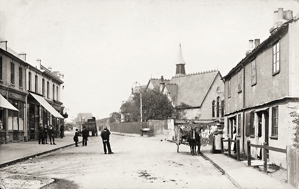
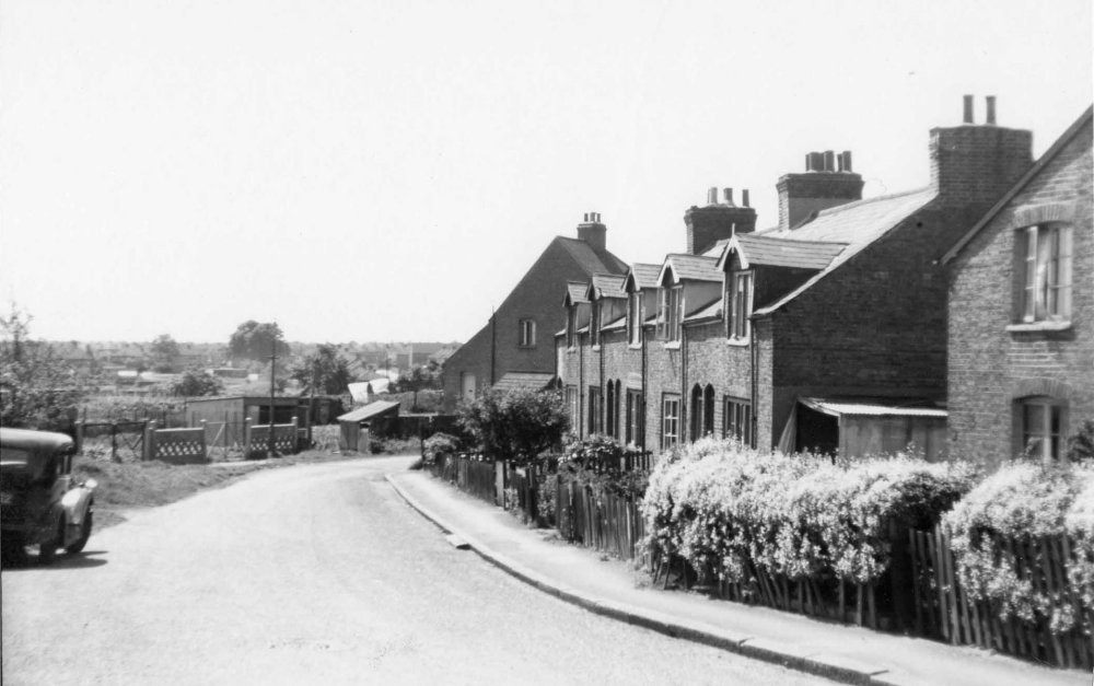
Cheshunt Road, DA17

Road in/near Belvedere, existing between 1892 and now.

 HOME  ·  ARTICLE  ·  MAPS  ·  STREETS  ·  BLOG  ·  CONTACT US 
(51.48217 0.14739, 51.482 0.147) 
MAP YEAR:175018001810182018301860190019502023Show map without markers
ZOOM:14 15 16 17 14 15 16 17 14 15 16 17 14 15 16 17 14 15 16 17 14 15 16 17 14 15 16 17 18 14 15 16 17 14 15 16 17 18
TIP: To create your own sharable map, right click on the map
Road · Belvedere · DA17 ·
August
30
2021
Cheshunt Road was built between 1892 and 1897.

Streets in this area took the name of Hertfordshire towns.


Licence: Creative Commons Attribution-ShareAlike Licence


Click here to explore another London street
We now have 642 completed street histories and 46858 partial histories
Find streets or residential blocks within the M25 by clicking STREETS


CONTRIBUTIONS TO THE LOCALITY


Chris Nash   
Added: 10 Jan 2022 22:54 GMT   

Shortlands Close, DA17
Shortlands Close and the flats along it were constructed in the mid-1990s. Prior to this, the area was occupied by semi-detached houses with large gardens, which dated from the post-war period and were built on the site of Railway Farm. The farm and its buildings spanned the length of Abbey Road, on the south side of the North Kent Line railway tracks.

Reply

LATEST LONDON-WIDE CONTRIBUTIONS TO THE PROJECT


Sue   
Added: 24 Sep 2023 19:09 GMT   

Meyrick Rd
My family - Roe - lived in poverty at 158 Meyrick Rd in the 1920s, moving to 18 Lavender Terrace in 1935. They also lived in York Rd at one point. Alf, Nell (Ellen), plus children John, Ellen (Did), Gladys, Joyce & various lodgers. Alf worked for the railway (LMS).

Reply
Born here
Michael   
Added: 20 Sep 2023 21:10 GMT   

Momentous Birth!
I was born in the upstairs front room of 28 Tyrrell Avenue in August 1938. I was a breach birth and quite heavy ( poor Mum!). My parents moved to that end of terrace house from another rental in St Mary Cray where my three year older brother had been born in 1935. The estate was quite new in 1938 and all the properties were rented. My Father was a Postman. I grew up at no 28 all through WWII and later went to Little Dansington School

Reply

Mike Levy   
Added: 19 Sep 2023 18:10 GMT   

Bombing of Arbour Square in the Blitz
On the night of September 7, 1940. Hyman Lubosky (age 35), his wife Fay (or Fanny)(age 32) and their son Martin (age 17 months) died at 11 Arbour Square. They are buried together in Rainham Jewish Cemetery. Their grave stones read: "Killed by enemy action"

Reply

Lady Townshend   
Added: 8 Sep 2023 16:02 GMT   

Tenant at Westbourne (1807 - 1811)
I think that the 3rd Marquess Townshend - at that time Lord Chartley - was a tenant living either at Westbourne Manor or at Bridge House. He undertook considerable building work there as well as creating gardens. I am trying to trace which house it was. Any ideas gratefully received

Reply

Alex Britton   
Added: 30 Aug 2023 10:43 GMT   

Late opening
The tracks through Roding Valley were opened on 1 May 1903 by the Great Eastern Railway (GER) on its Woodford to Ilford line (the Fairlop Loop).

But the station was not opened until 3 February 1936 by the London and North Eastern Railway (LNER, successor to the GER).

Source: Roding Valley tube station - Wikipedia

Reply
Comment
Kevin Pont   
Added: 30 Aug 2023 09:52 GMT   

Shhh....
Roding Valley is the quietest tube station, each year transporting the same number of passengers as Waterloo does in one day.

Reply

Kevin Pont   
Added: 30 Aug 2023 09:47 GMT   

The connection with Bletchley Park
The code-breaking computer used at Bletchley Park was built in Dollis Hill.

Reply
Comment
Kevin Pont   
Added: 29 Aug 2023 15:25 GMT   

The deepest station
At 58m below ground, Hampstead is as deep as Nelson’s Column is tall.

Source: Hampstead tube station - Wikipedia

Reply


NEARBY STREETS
Albany Road, DA17 Albany Road is a road in the DA17 postcode area
Albert Road, DA17 Albert Road is a main road in Belvedere.
Alfred Road, DA17 Alfred Road is named for Prince Alfred, Queen Victoria’s second son.
Barnfield Road, DA17 Barnfield Road is a road in the DA17 postcode area
Bedwell Road, DA17 Bedwell Road is a road in the DA17 postcode area
Bellring Close, DA17 Bellring Close is a road in the DA17 postcode area
Berkhampstead Road, DA17 Berkhampstead Road is a road in the DA17 postcode area
Bonham Close, DA17 A street within the DA17 postcode
Brook Street, DA17 Brook Street is a road in the DA17 postcode area
Camden Court, DA17 A street within the DA17 postcode
Chalfont Court, DA17 Chalfont Court is a road in the DA17 postcode area
Chapman Road, DA17 Chapman Road is a road in the DA17 postcode area
Charton Close, DA7 Charton Close is a road in the DA17 postcode area
Cray Road, DA17 Cray Road is a road in the DA17 postcode area
Dryhill Road, DA17 This is a street in the DA17 postcode area
Eardley Road, DA17 Eardley Road is a road in the DA17 postcode area
Erith Road, DA17 Erith Road is a road in the DA17 postcode area
Essenden Road, DA17 Essenden Road is a road in the DA17 postcode area
Fairmont Close, DA17 A street within the DA17 postcode
Fairmount Close, DA17 Fairmount Close is a road in the DA17 postcode area
Gloucester Road, DA17 A street within the DA17 postcode
Grosvenor Road, DA17 Grosvenor Road is a road in the DA17 postcode area
Grove Road, DA17 Grove Road is a road in the DA17 postcode area
Harold Avenue, DA17 Harold Avenue is a road in the DA17 postcode area
Havelock Road, DA17 Havelock Road is a road in the DA17 postcode area
Hertford Walk, DA17 A street within the DA17 postcode
Hoddesdon Road, DA17 Hoddesdon Road was built by the Eardley Estate around 1861.
Lessness Park, DA17 Lessness Park is a road in the DA17 postcode area
Lessness Road, DA17 Lessness Road is a road in the DA17 postcode area
Lullingstone Road, DA17 Lullingstone Road is a road in the DA17 postcode area
Lumley Close, DA17 Lumley Close is a road in the DA17 postcode area
Matfield Road, DA17 Matfield Road is a road in the DA17 postcode area
Mitre Court, DA17 A street within the DA17 postcode
Mossdown Close, DA17 Mossdown Close is a road in the DA17 postcode area
Napier Road, DA17 Napier Road is a road in the DA17 postcode area
Nelson Road, DA17 Nelson Road is a road in the DA17 postcode area
Nuxley Road, DA17 Nuxley Road was called Erith Road until 1938.
Osborne Road, DA17 Osborne Road is a road in the DA17 postcode area
Parsonage Manorway, DA17 The name Parsonage Manorway falls into a local tradition without being part of the tradition.
Parsonage Manorway, DA8 Parsonage Manorway is a road in the DA8 postcode area
Raglan Road, DA17 Raglan Road is a road in the DA17 postcode area
Redleaf Close, DA17 Redleaf Close is a road in the DA17 postcode area
Renshaw Close, DA17 Renshaw Close is a road in the DA17 postcode area
Roberts Road, DA17 Roberts Road is a road in the DA17 postcode area
Rutland Gate, DA17 Rutland Gate is a road in the DA17 postcode area
Salmon Road, DA17 Salmon Road lies off Brook Street.
Smarden Close, DA17 Smarden Close is a road in the DA17 postcode area
Standard Road, DA17 A street within the DA17 postcode
Stapley Road, DA17 Stapley Road is a road in the DA17 postcode area
Stream Way, DA17 Stream Way is a road in the DA7 postcode area
Stream Way, DA17 Stream Way is a road in the DA17 postcode area
Streamway, DA17 Streamway is a road in the DA17 postcode area
Swaylands Road, DA17 Swaylands Road is a road in the DA17 postcode area
Terence Court, DA7 A street within the DA17 postcode
Tolcairn Court, DA17 A street within the DA17 postcode
Trosley Road, DA17 Trosley Road is a road in the DA17 postcode area
Upper grove Road, DA17 Upper grove Road is a road in the DA17 postcode area
Vanessa Close, DA17 A street within the DA17 postcode
Venmead Court, DA17 A street within the DA17 postcode
Victoria Street, DA17 Victoria Street is a road in the DA17 postcode area
Wadeville Close, DA17 Wadeville Close is a road in the DA17 postcode area
Walden Close, DA17 A street within the DA17 postcode
Walsingham Walk, DA17 Walsingham Walk is a road in the DA17 postcode area
Wellington Road, DA17 A street within the DA17 postcode
Woolwich Road, DA17 Woolwich Road is a road in the DA17 postcode area
Wynford Place, DA17 A street within the DA17 postcode

NEARBY PUBS
Eardley Arms The Eardley Arms dates from 1789 and is named after Sampson Gideon, first Lord Eardley (1745-1824) owner of Belvedere House.


Click here to explore another London street
We now have 630 completed street histories and 46870 partial histories


Belvedere

The area which is today known as Belvedere was for centuries part of Lesness Heath, the eastern parts of a narrow high ridge which stretches from the area of Lesnes Abbey to Erith.

The northern stretch is industrial and environmental and was common meadow. In 1847 this largely uncultivated, wooded estate, almost undivided was given by operation of the will of last Lord Saye and Sele to his cousin Sir Culling Eardley, who built properties in Belvedere until his death in 1863.

Eardley constructed a large wooden tower on the heath to gain views over his estate to the river Thames, giving the area its name from the Italian 'beautiful view'. The name can also be applied today, as the ridge of the area, and parts of its southern uplands, have commanding views towards Canary Wharf and Central London.

Until the adoption of the name Belvedere, the area was known as Picardy.

Eardley was persuaded to allow the construction on his property, of a Dissenters' chapel, which was built so that the original wooden belvedere became its tower. In order that the public were able to attend this chapel, he constructed paths to it across Lesness Heath. Eardley had finished in 1861, after nearly 8 years of building, his chapel, now All Saints' Church, after the earlier chapel burned down on the same site. At the same time Eardley constructed Villa Houses and reinforced the heath path to become Erith Road. The village of Belvedere soon grew up along the path which became Nuxley Road as Eardley gradually sold off the land.

Belvedere formed part of the Municipal Borough of Erith before 1965 and development took place before the Second World War, with significant reconstruction after the Blitz. Despite this, Upper Belvedere and The Village still retains much of its Victorian and Edwardian charm and character.

Upper Belvedere features a fine church and some modest brick villas. Lower Belvedere is better known for a Methodist chapel, a football club and a high technology sludge incinerator, which is an unexpected landmark on the south bank of the river Thames. Belvedere railway station, opened in 1859, is in Lower Belvedere and is served by the North Kent Line.


LOCAL PHOTOS
Click here to see map view of nearby Creative Commons images
Click here to see Creative Commons images near to this postcode
Click here to see Creative Commons images tagged with this road (if applicable)
Bexley Road, Belvedere, c. 1900
TUM image id: 1557144405
Licence: CC BY 2.0
Bexley Road, Upper Belvedere, c. 1930
TUM image id: 1557150771
Licence: CC BY 2.0
Brook Street, Belvedere, c. 1900
TUM image id: 1557162833
Licence: CC BY 2.0

In the neighbourhood...

Click an image below for a better view...
Bexley Road, Belvedere, c. 1900
Licence: CC BY 2.0


The Eardley Arms in Belvedere dates from 1789. It was named after Sampson Gideon, first Lord Eardley (1745-1824) owner of Belvedere House. The public house was rebuilt in the 1860s.
Credit: Bexley Archives
Licence:


Albert Road, Belvedere. The shops on the right are still there.
Credit: Erith and Belvedere Local History Society
Licence: CC BY 2.0


Nuxley Road, Belvedere (1930s). Until 1939 it was called Bexley Road.
Licence: CC BY 2.0


Hoddesdon Road, Belvedere in Erith was built by the Eardley Estate around 1861. From Hoddesdon Road it is possible to see St Paul’s Church, Northumberland Heath in the distance.
Credit: Bexley Archives
Licence:


Print-friendly version of this page

  Contact us · Copyright policy · Privacy policy