Prime meridian (Greenwich)

The prime meridian is a geographical reference line that passes through the Royal Observatory, Greenwich, in London..

 HOME  ·  ABOUT  ·  ARTICLE  ·  MARKERS OFF  ·  BLOG 
(51.476 0, 51.476 0) 
MAP YEAR:175018001810182018301860190019502024 
Use the control in the top right of the map above to view this area on another historic map
 
Article · * · SE10 ·
0
The prime meridian is a geographical reference line that passes through the Royal Observatory, Greenwich, in London.

The prime meridian was first established by Sir George Airy in 1851, and by 1884, over two-thirds of all ships and tonnage used it as the reference meridian on their charts and maps. In October of that year, at the behest of US President Chester A. Arthur, 41 delegates from 25 nations met in Washington, D.C., United States, for the International Meridian Conference. This conference selected the meridian passing through Greenwich as the official prime meridian due to its popularity.

The prime meridian was long symbolised by a brass strip in the Royal Observatory courtyard, now replaced by stainless steel, and since 16 December 1999, it has been marked by a powerful green laser shining north across the London night sky.
..

Main source: Wikipedia
Further citations and sources


Click here to explore another London street
We now have 670 completed street histories and 46830 partial histories
Find streets or residential blocks within the M25 by clicking STREETS

...

CONTRIBUTIONS TO THE LOCALITY

None so far :(
LATEST LONDON-WIDE CONTRIBUTIONS TO THE PROJECT


Added: 7 Jul 2024 16:26 GMT   

Haycroft Gardens, NW10
My Grandfather bought No 45 Buchanan Gdns in I believe 1902 and died ther in the early 1950s

Reply
Comment
   
Added: 7 Jul 2024 16:20 GMT   

Haycroft Gardens, NW10
I lived in No 7 from 1933 to 1938

Reply

Sylvia guiver   
Added: 4 Jul 2024 14:52 GMT   

Grandparents 1937 lived 37 Blandford Square
Y mother and all her sisters and brother lived there, before this date , my parent wedding photographers were take in the square, I use to visit with my mother I remember the barge ballon in the square in the war.

Reply
Born here
Roy Mathieson   
Added: 27 Jun 2024 16:25 GMT   

St Saviours
My great grandmother was born in Bowling Green Lane in 1848. The family moved from there to Earl Terrace, Bermondsey in 1849. I have never been able to locate Earl Terrace on maps.

Reply

   
Added: 26 Jun 2024 13:10 GMT   

Buckhurst Street, E1
Mt grandfather, Thomas Walton Ward had a musical instrument workshop in Buckhurst Street from 1934 until the street was bombed during the war. Grandfather was a partner in the musical instrument firm of R.J. Ward and Sons of Liverpool. He died in 1945 and is buried in a common grave at Abney Park Cemetery.

Reply
Lived here
Mike Dowling   
Added: 15 Jun 2024 15:51 GMT   

Family ties (1936 - 1963)
The Dowling family lived at number 13 Undercliffe Road for
Nearly 26 years. Next door was the Harris family

Reply
Comment
Evie Helen   
Added: 13 Jun 2024 00:03 GMT   

Vickers Road
The road ’Vickers Road’ is numbered rather differently to other roads in the area as it was originally built as housing for the "Vickers" arms factory in the late 1800’s and early 1900s. Most of the houses still retain the original 19th century tiling and drainage outside of the front doors.

Reply

Paul Harris    
Added: 12 Jun 2024 12:54 GMT   

Ellen Place, E1
My mother’s father and his family lived at 31 Ellen Place London E1 have a copy of the 1911 census showing this

Reply


LOCAL PHOTOS
Click here to see map view of nearby Creative Commons images
Click here to see Creative Commons images near to this postcode
Crooms Hill (1937)
TUM image id: 1657290361
Licence: CC BY 2.0
Gloucester Circus (1960s)
TUM image id: 1657291606
Licence: CC BY 2.0

In the neighbourhood...

Click an image below for a better view...
This image of Pluto, released on 23 July 2015, clearly shows the now familiar heart-shaped region nicknamed Tombaugh Regio. The photo is actually a combination of observations from the main camera on New Horizons (called LORRI) and the probe’s visible/infrared imager (known as Ralph) which provided data for the colours in the view. The enhanced colours allow scientists to identify differences in the composition and texture of Pluto’s surface, according to a NASA image description.
Licence:


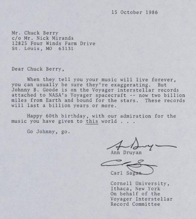
Letter to Chuck Berry from Carl Sagan (1986)
Licence:


Russell Croman took this detailed photo of the waxing Moon.
Credit: Russell Croman
Licence:


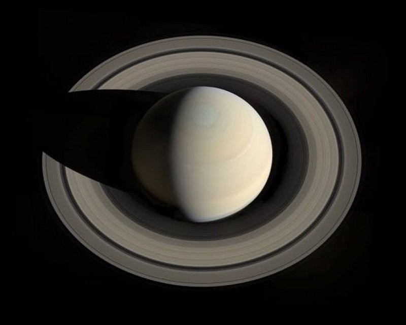
Saturn and its rings, as seen from above the planet by the Cassini spacecraft
Credit: NASA/JPL/Space Science Institute
Licence:


The establishment of a Royal Observatory in Greenwich, London was proposed in 1674 by Sir Jonas Moore who, in his role as Surveyor-General of the Ordnance, persuaded King Charles II to create the observatory, with John Flamsteed installed as its director. Royal Observatory, Greenwich (ROG) played a major role in the history of astronomy and navigation, and because the Prime Meridian passes through it, it gave its name to Greenwich Mean Time, the precursor to today’s Coordinated Universal Time (UTC). The ROG has the IAU observatory code of 000, the first in the list.
Credit: Kjetil Bjørnsrud
Licence:


The Statue of Yuri Gagarin in Greenwich, London, is a zinc statue depicting the cosmonaut wearing a spacesuit and standing on top of a globe.
Credit: Anatoly Novikov
Licence:


The foothills of the Andes Mountains near the southern coast of Peru were captured by the Kompsat-2 satellite. The Andes stretch from Venezuela down South America’s west coast to the top of Argentina. The mountain rage is the result of the Nazca and Antarctic tectonic plates moving under the South American plate—a geological process called subduction. This process is also responsible for the Andes range’s volcanic activity.
Credit: KARI
Licence:


Star Dunes in Algeria. The image was acquired by the Advanced Spaceborne Thermal Emission and Reflection Radiometer (ASTER) on NASA’s Terra satellite on October 27, 2012. It was made from a combination of near-infrared and visible light. In this type of false-color image, sand is tan and shadows are black or gray. The blue-tinted areas are likely mineral-rich evaporites. The image is centered at 29.8°north latitude, 7.9°east longitude, near the town of Gadamis. As is common with star dunes, some of the dunes have long interlacing arms connecting to nearby dunes.
Credit: NASA/GSFC/METI/ERSDAC/JAROS/ASTER Science Team
Licence:


Crooms Hill (1937)
Licence: CC BY 2.0


Maze Hill SE10
Credit: GoArt/The Underground Map
Licence:


  Contact us · Copyright policy · Privacy policy