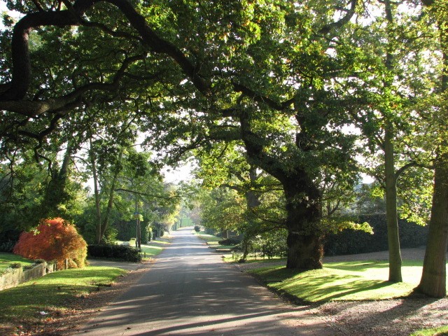
Kewferry Drive, HA6

Road in/near Northwood, existing between 1935 and now

 HOME  ·  ABOUT  ·  ARTICLE  ·  MARKERS ON  ·  BLOG 
(51.61755 -0.44105, 51.617 -0.441) 
MAP YEAR:18001810182018301860190019502025 
 
Road · * · HA6 ·
December
30
2020
Kewferry Drive connects Rickmansworth Road and Kewferry Road.

The hilly part of Rickmansworth Road was formerly Kewferry Hill. Kewferry is probably derived from the name of John de Kevere, who had dealings with the Abbey of Bec over property in Northwood in the 1290s. Kewferry spawned in turn a Kewferry Road and a Kewferry Drive.

Kewferry Drive is a private road with houses dating from the 1930s.

The now-closed entrance shaft to Northwood Chalk Mine lies beneath the drive of a bungalow in Kewferry Drive. Brickwork on the entrance shaft dates from the 17th century. The debris heap at the foot of the shaft was excavated and found to contain the complete skeletons of a horse and cow, old tin cans, a complete metal trough, a tin trunk that contained parts of a gin trap, some dissecting needles, parts of a windlass, an excavation tool and two bone implements used for making pins.

The shaft was rediscovered by a Mr Roy in 1946 when, within two days of returning from war service, he fell through the rotted sleepers.


This website does not sell maps. Instead it offers a subscription service via Substack using which you can download unlimited maps.

Find out how to use the service by clicking ABOUT above and finding the section which says How to use the mapping service.


Main source: Edith’s Streets
Further citations and sources


Click here to explore another London street
We now have 682 completed street histories and 46818 partial histories
Find streets or residential blocks within the M25 by clicking STREETS


NEARBY STREETS
Anson Walk, HA6 Anson Walk is a road in the HA6 postcode area (Moor Park)
Batchworth Heath Farm, WD3 A street within the WD3 postcode (Rickmansworth)
Batchworth Heath, WD3 A street within the WD3 postcode (Rickmansworth)
Birch Court, HA6 Birch Court is one of the streets in the Harrow postal district of Middlesex
Carlton Place, HA6 Carlton Place is a location in London
Cedar Place, HA6 Cedar Place is a location in London
Chestnut Cottages, WD3 A street within the WD3 postcode (Rickmansworth)
College Way, HA6 College Way is a road in the HA6 postcode area
Ducks Hill Road, HA6 Ducks Hill Road is a location in London
Ebury Close, HA6 Ebury Close is a road in the HA6 postcode area
Elmsdene Mews, HA6 A street within the HA6 postcode
Fairfield Close, HA6 Fairfield Close is a location in London
Farm Road, HA6 Farm Road is a road in the HA6 postcode area
Gateway Close, HA6 Gateway Close is one of the streets in the Harrow postal district of Middlesex
Harrison Close, HA6 Harrison Close is one of the streets in the Harrow postal district of Middlesex
Hedgeside Road, HA6 Hedgeside Road is a road in the HA6 postcode area
High Elms Close, HA6 High Elms Close is a road in the HA6 postcode area
Kewferry Drive, HA6 Kewferry Drive connects Rickmansworth Road and Kewferry Road
Kewferry Road, HA6 Kewferry Road is one of the streets in the Harrow postal district of Middlesex
Langton Grove, HA6 Langton Grove is a road in the HA6 postcode area
Merrows Close, HA6 Merrows Close is a road in the HA6 postcode area
Nevil Close, HA6 Nevil Close is a road in the HA6 postcode area (Moor Park)
New Farm Lane, HA6 New Farm Lane is a road in the HA6 postcode area
Old Gannon Close, HA6 Old Gannon Close is a road in the HA6 postcode area (Moor Park)
Oxford Close, HA6 Oxford Close is a road in the HA6 postcode area (Moor Park)
Park Farm House, HA6 Park Farm House is a location in London
Rising Hill Close, HA6 Rising Hill Close is a road in the HA6 postcode area
Russell Close, HA6 Russell Close is a road in the HA6 postcode area (Moor Park)
Sandhurst Court, HA6 Sandhurst Court is a location in London
Tanworth Close, HA6 Tanworth Close is one of the streets in the Harrow postal district of Middlesex
Thirlmere Gardens, HA6 Thirlmere Gardens is one of the streets in the Harrow postal district of Middlesex
Treetops Close, HA6 Treetops Close is a road in the HA6 postcode area
White Hill, HA6 White Hill is a road in the WD3 postcode area


Click here to explore another London street
We now have 682 completed street histories and 46818 partial histories


Click here to see photos of the area


  Contact us · Copyright policy · Privacy policy

32687:21760