Area photos
Choose a location
Abbey Road
Abbey Wood
Abridge
Acton
Acton Central
Acton Town
Addington
Addiscombe
Addlestone
Albany Park
Aldgate
Aldgate East
Aldwych
All Saints
Alperton
Amersham
Angel
Archway
Arena
Arkley
Arnos Grove
Arsenal
Aveley
Baker Street
Balham
Bank
Barbican
Barking
Barking Riverside
Barkingside
Barnehurst
Barnes
Barnes Bridge
Barnes Cray
Barnsbury
Barons Court
Batchworth
Battersea
Battersea Park
Battersea Power Station
Bayswater
Becontree
Beddington
Belgravia
Belhus,
Bellingham
Belmont (Middlesex)
Belsize Park
Belvedere
Bermondsey
Berrylands
Bethnal Green
Bexley
Bexleyheath
Bickley
Birkbeck
Blackfriars
Blackheath
Blackhorse Lane
Blackhorse Road
Bloomsbury
Bond Street
Borehamwood
Borough
Boston Manor
Bounds Green
Bow
Bow Church
Bow Road
Bowes Park
Brent Cross
Brent Cross West
Brentford
Bricket Wood
Brixton
Brockley
Brockley Hill
Bromley Common
Bromley North
Bromley South
Bromley-by-Bow
Brompton
Brondesbury
Brondesbury Park
Brooklands
Bruce Grove
Buckhurst Hill
Burgess Park
Burnt Oak
Bushey
Bushey Heath
Byfleet and New Haw
Caledonian Road
Camberwell
Cambridge Heath
Camden Road
Camden Town
Canada Water
Canary Wharf
Canning Town
Cannon Street
Canons Park
Carpenders Park
Catford
Catford Bridge
Chadwell Heath
Chalfont & Latimer
Chalk Farm
Chancery Lane
Chandler’s Cross
Charing Cross
Charlton
Chelsea
Chenies
Chertsey
Chesham
Chevening
Child’s Hill
Chipping Barnet
Chiswick
Chorleywood
City of London
City Thameslink
Clapham Common
Clapham High Street
Clapham Junction
Clapham North
Clapham South
Claremont
Clerkenwell
Clock House
Cockfosters
Colindale
Coombe (Croydon)
Coombe (Kingston)
Corbets Tey
Cottenham Park
Coulsdon
Covent Garden
Cowley
Cranham
Crayford
Crayford Ness
Creekmouth
Cricklewood
Crossharbour
Crouch End
Crouch Hill
Croxley
Croydon
Crystal Palace
Cubitt Town
Cudham
Cutty Sark
Dagenham East
Dagenham Heathway
Dalston
Dalston Junction
Dalston Kingsland
Dancers Hill
Dartford
Debden
Denham
Denmark Hill
Deptford
Devons Road
Dollis Hill
Dormers Wells
Downham
Drayton Green
Drayton Park
Dulwich
Ealing Broadway
Ealing Common
Earl’s Court
Earlsfield
East Acton
East Croydon
East Finchley
East Ham
East Molesey
East Putney
Eastcote
Edgware
Edgware Road
Edgwarebury
Egham Hythe
Elephant and Castle
Elm Park
Elmers End
Elstree
Elstree and Borehamwood
Eltham
Elverson Road
Embankment
Emerson Park
Enfield
Enfield Island Village
Enfield Town
Epping
Epsom
Esher
Essex Road
Euston
Euston Square
Fairlop
Farnborough
Farringdon
Feltham
Fenchurch Street
Finchley Central
Finchley Road
Finchley Road And Frognal
Finsbury Park
Fitzrovia
Force Green
Forest Gate
Forest Hill
Fortis Green
Fortune Green
Friern Barnet
Fulham
Fulham Broadway
Gallions Reach
Gants Hill
Garston
Gloucester Road
Golders Green
Goldhawk Road
Goodge Street
Goodmayes
Gospel Oak
Grahame Park
Gravel Hill
Great Portland Street
Green Park
Greenford
Greenwich
Grove Park
Hacton
Halstead
Ham
Hammersmith
Hampstead
Hampstead Garden Suburb
Hampstead Heath
Hanwell
Harefield
Harlesden
Harmondsworth
Harold Hill
Harold Park
Harringay
Harrow & Wealdstone
Harrow-on-the-Hill
Hatch End
Hatton Cross
Hawley
Hayes (Middlesex)
Hayes and Harlington
Hayes End
Headstone Lane
Heathrow
Heathrow Terminal 5
Hendon
Hendon Central
Herne Hill
Heron Quays
High Street Kensington
Highams Park
Highbury & Islington
Highgate
Hillingdon
Holborn
Holland Park
Holloway Road
Honor Oak
Hornchurch
Hounslow East
Hounslow West
Hoxton
Hyde Park Corner
Ickenham
Imperial Wharf
Island Gardens
Islington
Joyden’s Wood
Kennington
Kensal Green
Kensal Rise
Kensal Town
Kensington
Kensington (Olympia)
Kentish Town
Kentish Town West
Kenton
Keston
Kew Green
Kilburn
Kilburn High Road
Kilburn Park
King’s Cross St Pancras
Kingsbury
Knightsbridge
Knockholt
Ladbroke Grove
Laleham
Lambeth
Lambeth North
Lancaster Gate
Langdon Park
Latimer
Latimer Road
Lavender Hill
Lea Bridge
Leicester Square
Letchmore Heath
Lewisham
Leytonstone
Limehouse
Little Chalfont
Little Ilford
Little Venice
Liverpool Street
Lloyd Park
London Bridge
London City Airport
Loughton
Maida Hill
Maida Vale
Malden Manor
Malden Rushett
Manor House
Mansion House
Maple Cross
Marble Arch
Marylebone
Mayfair
Maze Hill
Meridian Water
Mertsham
Mile End
Mill Hill
Mill Hill Broadway
Mill Hill East
Millwall
Mitcham
Mitcham Eastfields
Monken Hadley
Monks Orchard
Monument
Moor Park
Moorgate
Morden
Mornington Crescent
Mortlake
Mudchute
Muswell Hill
Neasden
New Addington
New Cross Gate
New Haw
New Southgate
Nine Elms
North Acton
North Dulwich
North End
North Finchley
North Greenwich
North Harrow
North Kensington
North Ockendon
North Wembley
North Woolwich
Northfields
Northwick Park
Northwood
Norwood Green
Notting Dale
Notting Hill
Notting Hill Gate
Nunhead
Oakwood
Old Street
Orpington
Osidge
Oval
Oxford Circus
Paddington
Parsons Green
Peckham
Peckham Rye
Penton Park
Pentonville
Perivale
Petersham
Piccadilly Circus
Pimlico
Plaistow
Plumstead
Pollards Hill
Pontoon Dock
Pooley Green
Poplar
Poyle
Preston Road
Pudding Mill Lane
Purfleet
Purley Oaks
Putney
Putney Bridge
Queens Park Estate
Queens Road Peckham
Queensbury
Queensmead
Queenstown Road
Queensway
Queen’s Park
Radlett
Rainham
Ravenscourt Park
Rayners Lane
Reeves Corner
Regent’s Park
Richmond
Rickmansworth
Ridge
Rippleside
Roding Valley
Roehampton
Romford
Rotherhithe
Roxeth
Royal Oak
Ruislip
Ruislip Common
Ruislip Gardens
Ruislip Manor
Russell Square
Sandilands
Scratchwood
Scrattons Farm,
Selsdon
Seven Sisters
Sewardstone
Sewardstonebury
Shadwell
Shenley
Shepherd’s Bush Market
Shepherds Bush
Shepperton
Shoreditch
Silvertown
Sipson
Slade Green
Sloane Square
Snaresbrook
Soho
Somers Town
South Acton
South Ealing
South End Green
South Harrow
South Kensington
South Kenton
South Lambeth
South Mimms
South Oxhey
South Ruislip
South Wimbledon
South Woodford
Southall
Southfields
Southgate
Southwark
Spitalfields
Spring Park
St George’s Hill
St Giles
St James’s
St James’s Park
St John’s Wood
St Pancras
St Paul’s
Staines
Stamford Brook
Stamford Hill
Stanmore
Stapleford Abbots
Stepney Green
Stockwell
Stoke D’Abernon
Stoke Newington
Stonebridge
Stonebridge Park
Stratford
Stratford High Street
Stratford International
Streatham
Streatham Vale
Sudbury Hill
Sudbury Town
Surbiton
Swanley
Swiss Cottage
Tadworth
Tatsfield
Teddington
Temple
Temple Fortune
Temple Park
Thamesmead
The Underground Map
Theydon Bois
Thorpe
Thorpe Lea
Tottenham Court Road
Totteridge
Totteridge And Whetstone
Tower Gateway
Tower Hill
Tufnell Park
Tulse Hill
Turnham Green
Turnpike Lane
Underhill
Upminster
Upminster Bridge
Upney
Upper Holloway
Upton Park
Uxbridge
Vauxhall
Victoria
Victoria Park
Walford
Walthamstow Central
Walworth
Wandsworth
Wandsworth Road
Wanstead
Wapping
Warlingham
Warren Street
Warwick Avenue
Waterloo
Watford
Watford High Street
Watford Junction
Wealdstone
Welling
Wembley Central
Wembley Park
West Acton
West Bedfont
West Brompton
West Croydon
West Drayton
West Ealing
West Ham
West Hampstead
West Harrow
West Hendon
West India Quay
West Kensington
West Kilburn
West Ruislip
Westbourne Green
Westbourne Park
Westcombe Park
Westminster
Weybridge
Whetstone
Whipps Cross
White City
White Hart Lane
Whitechapel
Whiteley Village
Willesden
Willesden Green
Willesden Junction
Wimbledon
Wimbledon Park
Winchmore Hill
Wood Green
Wood Lane
Woodford
Woodford Green
Woodmansterne
Woodside
Woodside Park
Woolwich
Yeading
Yiewsley
HOME
·
ARTICLE
·
MAPS
·
STREETS
·
BLOG
·
CONTACT US
(51.49749 -0.01997, 51.497 -0.019)
20190311:2
LOCAL PHOTOS
Click here to see map view of nearby Creative Commons images
Click here to see Creative Commons images near to this postcode
Click here to see Creative Commons images tagged with this road (if applicable)
Alpha Grove (1962) Alpha Grove (previously Alpha Road) runs from Strafford Street to Tiller Road on the Isle of Dogs. Alpha Grove ran right through to the West India Dock fence dock - its cranes can be seen at the end of the road. When built in the 1800s, Alpha Road followed a section of the old island path, Dolphin Lane. The road running across the view in the photo is Byng Street.
TUM image id:
1489324044
Licence:
1 Cabot Square
Credit: Jack8080
TUM image id:
1481482264
Licence: CC BY 2.0
Two Men on a Bench is one of two sculptures in Canary Wharf by Giles Penny.
Credit: www.walkmeblog.com
TUM image id:
1685539374
Licence: CC BY 2.0
The River Thames looking west as photographed from the restaurant at One Canada Place (2018)
Credit: The Underground Map
TUM image id:
1686915908
Licence: CC BY 2.0
A procession passing the corner of Chapel House Street and Westferry Road (1930s)
Credit: Island History Trust / Tony Atkinson
TUM image id:
1651500794
Licence: CC BY 2.0
’Blood Alley’ in the West India Docks, circa 1930. This photograph was taken at the North Quay shows a gang of dockers trucking bags of sugar beneath an awning of washed sacks that are hung out for drying at. ‘Blood Alley’ was the nickname given to roadway between the transit sheds and sugar warehouses because handling the sacks of sticky West Indian sugar badly chafed and cracked the dockers’ skin. This quay is now home to the Museum of London Docklands
Credit: PLA collection/Museum of London
TUM image id:
1685546420
Licence:
Children playing street cricket in Alpha Road, Millwall in August 1938. A ship - the Union Castle line “Dunbar Castle” can be seen in the background. The photo was taken close to its corner with Manilla Street. In the background, behind the dock fence are the West India Docks.
Credit: Hulton Archive/Getty Images
TUM image id:
1685036340
Licence:
Canary Wharf: West India Dock North Floating Footbridge (2018) The footbridge joins Wren’s Landing on Canary Wharf, from which this photograph was taken, with the North Quay of the West India Dock North. The footbridge was opened in 1996 and floats on a series of pontoons. The footbridge is about 94 metres long, covering an open water span of about 84 metres, and narrows towards its centre.
Credit: Geograph/Nigel Cox
TUM image id:
1685540785
Licence:
Thermopylae Gate, E14 (2022) Houses in the Chapel House Estate on the Isle of Dogs were designed in a ’Neo-Georgian’ style by Sir Frank Baines.
Credit: The Underground Map
TUM image id:
1651313864
Licence:
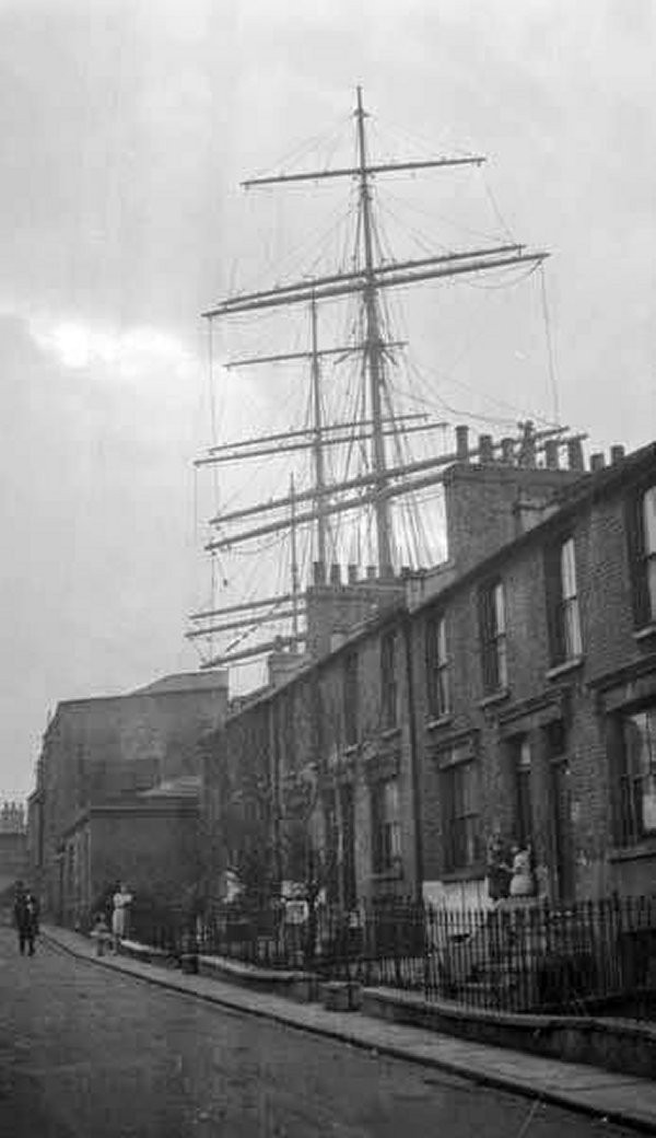
Deptford Ferry Road - view of Britannia Dock. Above the terraced houses the masts and yards of the barque Killoran can be seen under repair in Britannia Dry Dock in 1928.
Credit: Museum of London
TUM image id:
1570994888
Licence:
Aste Street
Credit: GoArt/The Underground Map
TUM image id:
1563620823
Licence: CC BY 2.0
The original Canary Wharf in London’s Docklands, just before its redevelopment to become the financial centre. It was situated on the site of today’s Cabot Square.
Credit: In Pictures Ltd/Corbis
TUM image id:
1685110625
Licence:
The North Pole
Credit: Island History Trust
TUM image id:
1575559918
Licence: CC BY 2.0
Aerial photo of Canary Wharf area, 1980
Credit: Port of London Authority
TUM image id:
1685013673
Licence:
L’Avenir in the Millwall Docks (1908)
TUM image id:
1630317490
Licence:
In the neighbourhood...
Click an image below for a better view...
Alpha Grove (1962) Alpha Grove (previously Alpha Road) runs from Strafford Street to Tiller Road on the Isle of Dogs. Alpha Grove ran right through to the West India Dock fence dock - its cranes can be seen at the end of the road. When built in the 1800s, Alpha Road followed a section of the old island path, Dolphin Lane. The road running across the view in the photo is Byng Street.
Licence:
Children playing street cricket in Alpha Road, Millwall in August 1938. A ship - the Union Castle line “Dunbar Castle” can be seen in the background. The photo was taken close to its corner with Manilla Street. In the background, behind the dock fence are the West India Docks.
Credit: Hulton Archive/Getty Images
Licence:
The North Pole
Credit: Island History Trust
Licence: CC BY 2.0
View of West India Docks from the south east in 1840. This was an age when the British Navy ruled the waves and goods were being shipped to and from London from America, India and Africa. West India Quay was given the name because ships landed here from the Caribbean carrying sugar produced on the plantations of Jamaica by slaves
Licence:
Beer in the evening
Credit: Wiki Commons
Licence: