Crystal Palace

Rail station, existing between 1854 and now.

 HOME  ·  ARTICLE  ·  MAPS  ·  STREETS  ·  BLOG  ·  CONTACT US 
(51.418 -0.072, 51.418 -0.072) 
MAP YEAR:175018001810182018301860190019502024Show map without markers
Use the control in the top right of the map above to view this area on another historic map
 
Rail station · * · SE19 ·
October
5
2012
Crystal Palace, the residential area, is named after the former local landmark, the Crystal Palace, which stood in the area from 1854 to 1936.

The area is located approximately 8 miles south east of Charing Cross and includes one of the highest points in London, at 112 metres, offering views over the capital.

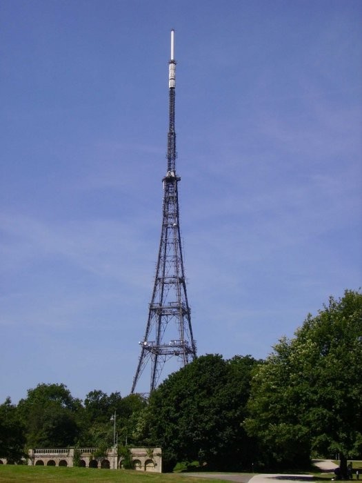
The district was a natural oak forest until development began in the 19th century, and before the arrival of the Crystal Palace the area was known as Sydenham Hill. The Norwood Ridge and an historic oak tree were used to mark parish boundaries. After the Crystal Palace burned down in 1936, the site of the building and its grounds became Crystal Palace Park, which is the location of the National Sports Centre, containing an athletics track, stadium and other sports facilities. Crystal Palace Park has also been the setting for a number of concerts and films, including scenes from The Italian Job and The Pleasure Garden. Two television transmitter masts make the district a landmark location, visible from many parts of Greater London. Local landmarks include the Crystal Palace Triangle, a shopping district made up of three streets forming a triangle; Westow Park, a smaller park that lies off the triangle to the south west of Crystal Palace Park; and the Stambourne Woodland Walk.

A pneumatic railway was briefly trialled in the area in 1864. Once the railways had arrived, Crystal Palace was eventually served by two railway stations, the high level (1865) and low level (1854) stations, built to handle the volume of passengers visiting the Crystal Palace. After the palace was destroyed by fire, and with railway travel declining in the UK more generally, passenger numbers fell and the high level station was closed in 1954 and demolished seven years later. Rail services gradually declined, and for a period in the 1960s and 1970s there were plans to construct an urban motorway through the area as part of the London Ringways plan. More recently, rail travel has seen a resurgence in Crystal Palace, with rising passenger numbers, additional London Overground services stopping at the station since 2010 and a major station redevelopment in 2012.


Licence: Creative Commons Attribution-ShareAlike Licence


Click here to explore another London street
We now have 666 completed street histories and 46834 partial histories
Find streets or residential blocks within the M25 by clicking STREETS


CONTRIBUTIONS TO THE LOCALITY

None so far :(
LATEST LONDON-WIDE CONTRIBUTIONS TO THE PROJECT

Comment
   
Added: 2 May 2024 16:14 GMT   

Farm Place, W8
The previous name of Farm Place was Ernest St (no A)

Reply
Comment
Tony Whipple   
Added: 16 Apr 2024 21:35 GMT   

Frank Whipple Place, E14
Frank was my great-uncle, I’d often be ’babysat’ by Peggy while Nan and Dad went to the pub. Peggy was a marvel, so full of life. My Dad and Frank didn’t agree on most politics but everyone in the family is proud of him. A genuinely nice, knowledgable bloke. One of a kind.

Reply
Comment
Theresa Penney   
Added: 16 Apr 2024 18:08 GMT   

1 Whites Row
My 2 x great grandparents and his family lived here according to the 1841 census. They were Dutch Ashkenazi Jews born in Amsterdam at the beginning of the 19th century but all their children were born in Spitalfields.

Reply
Comment
Wendy    
Added: 22 Mar 2024 15:33 GMT   

Polygon Buildings
Following the demolition of the Polygon, and prior to the construction of Oakshott Court in 1974, 4 tenement type blocks of flats were built on the site at Clarendon Sq/Phoenix Rd called Polygon Buildings. These were primarily for people working for the Midland Railway and subsequently British Rail. My family lived for 5 years in Block C in the 1950s. It seems that very few photos exist of these buildings.

Reply

Steve   
Added: 19 Mar 2024 08:42 GMT   

Road construction and houses completed
New Charleville Circus road layout shown on Stanford’s Library Map Of London And Its Suburbs 1879 with access via West Hill only.

Plans showing street numbering were recorded in 1888 so we can concluded the houses in Charleville Circus were built by this date.

Source: Charleville Circus, Sydenham, London

Reply
Comment
Steve   
Added: 19 Mar 2024 08:04 GMT   

Charleville Circus, Sydenham: One Place Study (OPS)
One Place Study’s (OPS) are a recent innovation to research and record historical facts/events/people focused on a single place �’ building, street, town etc.

I have created an open access OPS of Charleville Circus on WikiTree that has over a million members across the globe working on a single family tree for everyone to enjoy, for free, forever.

Source: Charleville Circus, Sydenham, London

Reply
Comment
Charles   
Added: 8 Mar 2024 20:45 GMT   

My House
I want to know who lived in my house in the 1860’s.

Reply

NH   
Added: 7 Mar 2024 11:41 GMT   

Telephone House
Donald Hunter House, formerly Telephone House, was the BT Offices closed in 2000

Reply


NEARBY LOCATIONS OF NOTE
The very first Crystal Palace FC A football team was established at the Crystal Palace grounds leading to claims that Crystal Palace FC should be recognised as the oldest professional football club in the world.

NEARBY STREETS
Acorn Gardens, SE19 Acorn Gardens is a road in the SE19 postcode area
Alma Place, SE19 A street within the SE19 postcode
Alma Yard, SE19 Alma Yard is one of the streets of London in the SE19 postal area
Anerley Grove, SE19 Anerley Grove is a road in the SE19 postcode area
Anerley Hill, SE19 Anerley Hill is a major thoroughfare of the Crystal Palace area
Anerley Park Road, SE20 Anerley Park Road is a road in the SE20 postcode area
Anerley Park, SE20 Anerley Park is one of the streets of London in the SE20 postal area
Anerley Road, SE19 Anerley Road is one of the streets of London in the SE19 postal area
Anerley Vale, SE19 Anerley Vale is a road in the SE19 postcode area
Auckland Close, SE19 Auckland Close is a road in the SE19 postcode area
Auckland Gardens, SE19 Auckland Gardens is one of the streets of London in the SE19 postal area
Auckland Rise, SE19 Auckland Rise is a modern road lying between Oakland Wood and Beaulieu Heights
Auckland Road, SE19 Auckland Road is one of the streets of London in the SE19 postal area
Bargrove Close, SE20 Bargrove Close is one of the streets of London in the SE20 postal area
Battenberg Walk, SE19 A street within the SE19 postcode
Beardell Street, SE19 Beardell Street is one of the streets of London in the SE19 postal area
Bedwardine Road, SE19 Bedwardine Road is one of the streets of London in the SE19 postal area
Beechwoods Court, SE19 A street within the SE19 postcode
Belvedere Court, SE19 Belvedere Court is a block on Belvedere Road
Belvedere Road, SE19 Belvedere Road is one of the streets of London in the SE19 postal area
Bowley Close, SE19 Bowley Close is one of the streets of London in the SE19 postal area
Braybrooke Gardens, SE19 A street within the SE19 postcode
Bridgewood Close, SE20 Bridgewood Close is a road in the SE20 postcode area
Brooklyn House, SE20 Brooklyn House is a block on Anerley Road
Brunel Close, SE19 A street within the SE19 postcode
Brunswick Court, SE19 Brunswick Court is a block on Anerley Road
Brunswick Place, SE19 Brunswick Place is a road in the SE19 postcode area
Buckleigh Way, SE19 Buckleigh Way is a road in the SE19 postcode area
Burntwood View, SE19 A street within the SE19 postcode
Canterbury House, SE19 Canterbury House is a block on Hermitage Road
Cantley Gardens, SE19 Cantley Gardens is a road in the SE19 postcode area
Carlton Court, Carlton Court is located on Auckland Road
Carlton Court, SE19 Carlton Court is a block on Auckland Road
Castledine Road, SE20 Castledine Road is one of the streets of London in the SE20 postal area
Castleton Court, SE19 Castleton Court is a block on Maberley Road
Cawnpore Street, SE19 Cawnpore Street is one of the streets of London in the SE19 postal area
Central Hill, SE19 Central Hill is one of the streets of London in the SE19 postal area
Chalkenden Close, SE20 Chalkenden Close is one of the streets of London in the SE20 postal area
Charters Close, SE19 Charters Close is one of the streets of London in the SE19 postal area
Chipstead Close, SE19 A street within the SE19 postcode
Church Road, SE19 Church Road leads south from Upper Norwood
Cintra Court, SE19 Cintra Court is a block on Patterson Road
Cintra Park, SE19 Cintra Park is one of the streets of London in the SE19 postal area
Claybourne Mews, SE19 Claybourne Mews is one of the streets of London in the SE19 postal area
Cloister House, SE19 Cloister House is a block on Central Hill
Clovelly Gardens, SE19 Clovelly Gardens is a road in the SE19 postcode area
College Road, SE19 College Road is one of the streets of London in the SE19 postal area
Copper Close, SE19 Copper Close is a road in the SE19 postcode area
Crystal Court, SE19 Crystal Court is a building on Lymer Avenue
Crystal Palace Station Road, SE19 Crystal Palace Station Road is a road in the SE19 postcode area
Dargate Close, SE19 A street within the SE19 postcode
Darwin House, SE20 Darwin House is a block on Worcester Close
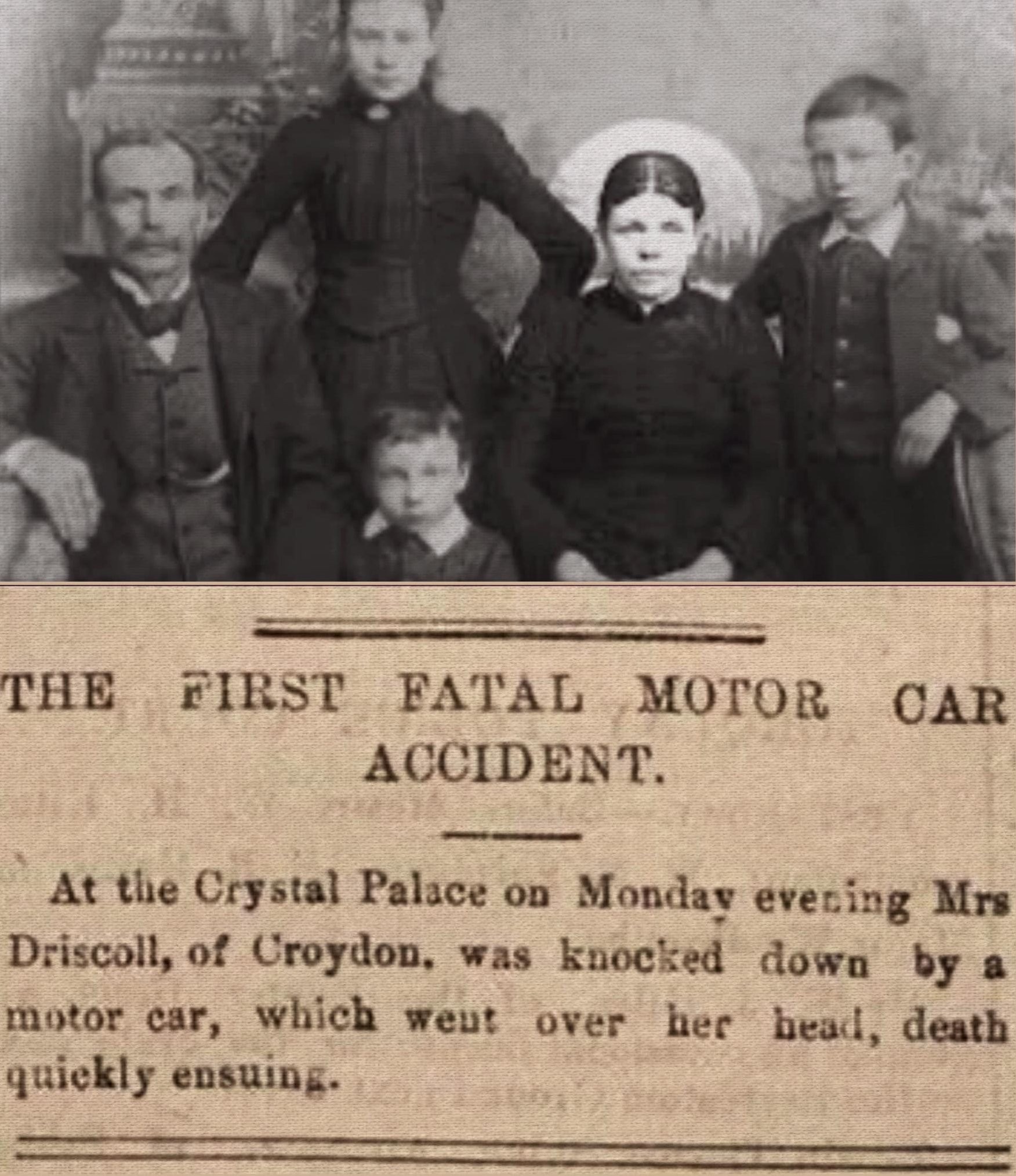
Dolphin Terrace, SE19 Dolphin Terrace was the location of the first fatality involving a car striking a pedestrian on 17th August 1896
Drake Court, SE19 Drake Court is a block on Tylney Avenue
Durning Road, SE19 Durning Road is one of the streets of London in the SE19 postal area
East Palace, SE19 East Palace is one of the streets of London in the SE19 postal area
Enderley House, SE19 Enderley House is a block on Sylvan Road
Fitzroy Gardens, SE19 Fitzroy Gardens is one of the streets of London in the SE19 postal area
Forbes Court, SE19 Forbes Court is a block on Forbes Court
Fox Hill Gardens, SE19 A street within the SE19 postcode
Fox Hill, SE19 Fox Hill runs east from Church Road
Gatestone Court, SE19 Gatestone Court is a block on Central Hill
Gatestone Road, SE19 Gatestone Road is a road in the SE19 postcode area
Giles Coppice, SE19 Giles Coppice extends south from Kingswood Drive, stopping just short of Dulwich Wood Park.
Gipsy Hill, SE19 Gipsy Hill is the name of the main road that runs from Gipsy Road, near its junction with South Croxted Road, up to Westow Hill in Upper Norwood
Glebe Hyrst, SE19 A street within the SE19 postcode
Glenhurst Court, SE19 Glenhurst Court is a block on Glenhurst Court
Gould Court, SE19 Gould Court is located on Woodland Road
Grazeley Court, SE19 Grazeley Court is a block on Grazeley Court
Grenville Court, SE19 Grenville Court is located on Lymer Avenue
Grosvenor Court, SE19 Grosvenor Court is a block on Anerley Hill
Hadlow Place, SE19 A street within the SE19 postcode
Hamlet Road, SE19 Hamlet Road is one of the streets of London in the SE19 postal area
Hamlyn Gardens, SE19 Hamlyn Gardens is a road in the SE19 postcode area
Hanover Court, SE19 Hanover Court is a block on Anerley Road
Hawke Road, SE19 Hawke Road is a road in the SE19 postcode area
Haynes Lane, SE19 Haynes Lane is one of the streets of London in the SE19 postal area
Hetley Gardens, SE19 A street within the SE19 postcode
Hill House, SE19 Hill House is a block on Central Hill
Homelands Drive, SE19 Homelands Drive is one of the streets of London in the SE19 postal area
Jasper Road, SE19 Jasper Road is located at the far south-western extremity of Dulwich manor
Jenson Way, SE19 Jenson Way is a road in the SE19 postcode area
Kendall Court, SE19 Kendall Court is a building on Tudor Road
Kestrel House, SE19 Kestrel House is a block on Mowbray Road
Kingswood Drive, SE19 Kingswood Drive takes its name from Kingswood House, built by William Vizard in 1811.
Kitley Gardens, SE19 Kitley Gardens is one of the streets of London in the SE19 postal area
Knoll Court, SE19 Knoll Court can be found on Farquhar Road
Lansdowne Place, SE19 Lansdowne Place is a road in the SE19 postcode area
Ledrington Road, SE19 Ledrington Road is one of the streets of London in the SE19 postal area
Limekiln Place, SE19 Limekiln Place is a road in the SE19 postcode area
London Walk, SE19 London Walk is a road in the E15 postcode area
Lou Hamer House, SE19 Lou Hamer House is a building on Hadlow Place
Lowood Court, SE19 Lowood Court is sited on Farquhar Road
Lullington Road, SE20 Lullington Road is a road in the SE20 postcode area
Lymer Avenue, SE19 Cornelius Lymer, then Chaplain of Christchurch College, Oxford, was appointed the first Chaplain to Alleyn’s College in 1616
Maberley Court, SE19 Maberley Court is a building on Maberley Crescent
Maberley Crescent, SE19 Maberley Crescent is a road in the SE19 postcode area
Maberley Road, SE20 Maberley Road is one of the streets of London in the SE19 postal area
Marlowe Court, SE19 Marlowe Court is a block on Lymer Avenue
Mason Court, SE19 Mason Court is a building on Belvedere Road
Mayville Court, SE19 Mayville Court can be found on Sylvan Road
Melbourne Court, SE20 Melbourne Court is a block on Melbourne Court
Milestone Road, SE19 Milestone Road is a road in the SE19 postcode area
Miller House, SE20 Miller House can be found on Anerley Road
Mollie Davies Court, SE19 Mollie Davies Court is a block on Church Road
Mowbray Road, SE19 Mowbray Road is a road in the SE19 postcode area
Neil Gomer House, SE19 Neil Gomer House is a block on Hamlet Road
Nesbitt Square, SE19 Nesbitt Square is one of the streets of London in the SE19 postal area
New Church Court, SE19 New Church Court is located on Waldegrave Road
Nightingale Court, SE19 Nightingale Court is a block on Church Road
Oaks Avenue, SE19 Oaks Avenue is a road in the SE19 postcode area
Orchard Grove, SE20 Orchard Grove is a road in the SE19 postcode area
Orchard Grove, SE20 Orchard Grove is a road in the SE20 postcode area
Orchard Lodge Rescource Centre, SE19 Orchard Lodge Rescource Centre is a road in the SE19 postcode area
Osprey House, SE19 Osprey House is a block on Mowbray Road
Palace Grove, SE19 A street within the SE19 postcode
Palace Road, SE19 Palace Road is a road in the SE19 postcode area
Palace Square, SE19 Palace Square is a road in the SE19 postcode area
Park Lodge, SE19 Park Lodge is one of the streets of London in the SE19 postal area
Pascal Mews, SE19 A street within the SE19 postcode
Patterson Court, SE19 Patterson Court is a block on Patterson Road
Patterson Road, SE19 Patterson Road is a road in the SE19 postcode area
Paxton House, SE19 Paxton House is located on Hadlow Place
Paxton Mews, SE19 A street within the SE19 postcode
Pleydell Avenue, SE19 Pleydell Avenue is one of the streets of London in the SE19 postal area
Princess Court, SE19 Princess Court is a block on College Road
Raleigh Court, SE19 Raleigh Court can be found on Lymer Avenue
Rama Lane, SE19 A street within the SE19 postcode
Regency Court, SE19 Regency Court is a block on Hamlet Road
Reynard Drive, SE19 Reynard Drive is a road in the SE19 postcode area
Rochdale, SE19 Rochdale is one of the streets of London in the SE19 postal area
Rochester House, SE19 Rochester House can be found on Lansdowne Place
Roman Rise, SE19 Roman Rise is a road in the SE19 postcode area
Rooks Court, SE19 Rooks Court is located on Belvedere Road
Rosetta Court, SE19 Rosetta Court is a block on Church Road
Shelford Rise, SE19 Shelford Rise is a road in the SE19 postcode area
South Court, SE19 South Court is a block on South Court
South Vale, SE19 South Vale is one of the streets of London in the SE19 postal area
Southholme Close, SE19 Southholme Close is a road in the SE19 postcode area
Spinney Gardens, SE19 Spinney Gardens is one of the streets of London in the SE19 postal area
Spring Grove, SE19 A street within the SE19 postcode
Stambourne Way, SE19 Stambourne Way is one of the streets of London in the SE19 postal area
Stambourne Woodland Walk, SE19 Stambourne Woodland Walk is a road in the SE19 postcode area
Stoney Lane, SE19 Stoney Lane is one of the streets of London in the SE19 postal area
Summit Way, SE19 Summit Way is a road in the SE19 postcode area
Sutton Court, SE19 Sutton Court is a block on Belvedere Road
Sylvan Estate, SE19 The Sylvan Estate was an estate of 77 Uni-Seco prefabs
Sylvan Hill, SE19 Sylvan Hill is a road in the SE19 postcode area
Sylvan Road, SE19 Sylvan Road runs from Auckland Road to Maberley Road
Telford Close, SE19 Telford Close is a road in the SE19 postcode area
The Coach House, SE19 The Coach House can be found on Lansdowne Place
The Dell, SE19 A street within the SE19 postcode
The White House, SE19 The White House can be found on Waldegrave Road
Thicket Road, SE19 Thicket Road is a road in the SE19 postcode area
Thicket Road, SE20 Thicket Road is one of the streets of London in the SE20 postal area
Thicket Road, SE20 Thicket Road is a road in the SE26 postcode area
Thorsden Way, SE19 A street within the SE19 postcode
Tower Close, SE20 Tower Close is one of the streets of London in the SE20 postal area
Tree View Close, SE19 Tree View Close is a road in the SE19 postcode area
Trenholme Road, SE20 Trenholme Road is a road in the SE20 postcode area
Tudor Road, SE19 Tudor Road is a road in the SE19 postcode area
Turkey Oak Close, SE19 Turkey Oak Close is one of the streets of London in the SE19 postal area
Tylney Avenue, SE19 Edmund Tylney was Master of the Queen’s Revels under Elizabeth I in 1583
Upper Beulah Hill, SE19 Upper Beulah Hill is one of the streets of London in the SE19 postal area
Wakefield Gardens, SE19 Wakefield Gardens is a road in the SE19 postcode area
Waldegrave Road, SE19 Waldegrave Road is one of the streets of London in the SE19 postal area
Wickers Oake, SE19 Wickers Oake lies off Dulwich Wood Park.
Windall Close, SE19 Windall Close is a road in the SE19 postcode area
Wiseman Court, SE19 Wiseman Court is a block on Cawnpore Street
Woodland Road, SE19 Woodland Road is one of the streets of London in the SE19 postal area
Woodview Mews, SE19 A street within the SE19 postcode
Woodville Court, SE19 Woodville Court is a block on Sylvan Road

NEARBY PUBS


Click here to explore another London street
We now have 666 completed street histories and 46834 partial histories


LOCAL PHOTOS
Click here to see map view of nearby Creative Commons images
Click here to see Creative Commons images near to this postcode
Indoor bowling
TUM image id: 1529229197
Licence:

In the neighbourhood...

Click an image below for a better view...
Crystal Palace Transmitting Station Mast (2007)
Credit: Tv boy
Licence: CC BY 2.0


The Crystal Palace in Sydenham, before the 1936 fire, was a glorious construction of wood and glass.
Licence:


Crystal Palace from Anerley Hill (1906) Not only did the palace burn down in 1936 but a V1 largely demolished the buildings on the right in 1944. The remains of the water tower can still be seen today
Credit: TV Boy
Licence:


Fox Hill, Upper Norwood by Camille Pissarro (1830-1903) Camille Pissarro was born in St Thomas (then a Danish possession) in the West Indies but lived and worked mainly in the Paris area. He was an Impressionist and mainly painted landscapes. He visited London in 1870-71 and painted London views.
Credit: National Gallery, London
Licence:


The Sylvan Estate was an estate of prefabs off Maberley Road, SE19
Credit: Barrie McKay
Licence:


The death of Bridget Driscoll (c. 1851 – 17 August 1896) was the first recorded case of a pedestrian killed in a collision with a motor car in Great Britain. As 44-year-old Mrs Driscoll, with her teenage daughter May and her friend Elizabeth Murphy, crossed Dolphin Terrace in the grounds of the Crystal Palace, she was struck by a car belonging to the Anglo-French Motor Carriage Company that was being used for demonstration rides, driven by a Mr Edsell.
Licence:


FA Cup Final (Burnley v Liverpool) at Crystal Palace (1914) With any luck there were further attendance options alongside “standing on a post for 90 minutes”
Credit: Getty Images
Licence: CC BY 2.0


  Contact us · Copyright policy · Privacy policy