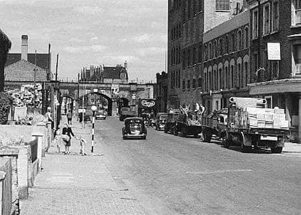
Latimer Road, W10

Road in/near Notting Dale, existed between 1863 and 1969

 HOME  ·  ABOUT  ·  ARTICLE  ·  MARKERS ON  ·  BLOG 
(51.51212 -0.21868, 51.512 -0.218) 
MAP YEAR:18001810182018301860190019502025 
 
Road · * · W10 ·
October
19
2020
Latimer Road was named after Edward Latymer who endowed land for the funding of Hammersmith’s Latymer school in the early 17th century.

Latimer Road’s position in the heart of the Notting Dale piggeries and potteries attracted philanthropists to try to alleviate the poverty. The local vestry also came forward with initiatives. In 1880 the London school board built the three-storey Latimer Road school. Harrow school also established a school on the street in 1887 and a mission, three years before that.

Poverty extended into the twentieth century. Horace Newte observed in 1915: “Between Notting Hill and Wormwood Scrubs lies a vast desert of human dwellings … by scarcely perceptible degrees, there is a declension of so-called respectability, till at last the frankly working-class district of Latimer Road is reached.”

After the war, planners had turned to rewiring London’s road systems with massive new motorway projects starting with the Westway which opened in 1969/1970. Part of the plan involved the complete demolition of a large part of Latimer Road. The section which remained in the south part of the old street was renamed Freston Road.

The Greater London Council planned to demolish much of Freston Road. Squatters occupied the houses and declared the ’Republic of Frestonia’ in 1977. A compromise was reached and new homes were completed in 1985.

The disappearance of Latimer Road has left Latitmer Road station unique in London in being named after, but not referring to, an existing road.

The Underground Map project is creating street histories for the areas of London and surrounding counties lying within the M25.

The aim of the project is to find the location every street in London, whether past or present, and tell its story. This project aims to be a service to historians, genealogists and those with an interest in urban design.

The website features a series of maps from the 1750s until the 1950s. You can see how London grows over the decades.


Main source: Hidden London
Further citations and sources


NEARBY LOCATIONS OF NOTE
Bangor Street (1911) Bangor Street was a street in Notting Dale which disappeared after the Second World War.
Bangor Street (turn of 20th century) The St Agnes soup kitchen was situated on the corner of Bangor Street that this photo was taken from.
Corner of Bangor Street and Sirdar Road The location became the Dolphin Pub.
Dimco Buildings The Dimco Buildings housed the earliest (extant) example of an electricity generating station built for the London Underground.
Earl of Zetland The Earl of Zetland - a pub in the Potteries
Kenilworth Castle The Kenilworth Castle was a post-war pub in Notting Dale.
Mary Place Workhouse Notting Dale Workhouse stood on the site of what is now Avondale Park Gardens,
Notting Dale From Pigs and bricks to Posh and Becks...
Ridler’s Tyre Yard Ridler’s Tyres was situated in a part of Blechynden Street which no longer exists
Television Centre Television Centre is a complex in White City that was the headquarters of BBC Television between 1960 and 2013.
The Brittania The Brittania was situated on the corner of Clarendon Road and Portland Road, W11.
Western Iron Works The Western Iron Works was the foundry business of James Bartle and Co.
White City bus station White City bus station serves the Westfield London shopping centre.
White City Place White City Place is a collection of buildings previously known as BBC Media Village.
Wood Lane (1914) Wood Lane - apparently London’s "go-to" station.

NEARBY STREETS
Alestan House, W10 Alestan House is a block on Freston Road (Notting Dale)
Ansleigh Place, W11 Ansleigh Place is an ex mews to the west of Notting Dale (Notting Dale)
Ariel Way, W12 Ariel Way connects White City bus station with Shephard’s Bush (Shepherds Bush)
Arthur Court, W10 Arthur Court is a block on Silchester Road (Notting Dale)
Avondale Park Gardens, W11 Avondale Park Gardens, unlike other roads in the area, was developed in the 1920s when it was laid out on the former workhouse site (Notting Dale)
Avondale Park Road, W11 Avondale Park Road is a street in Notting Hill (Notting Dale)
Bangor Street, W11 Bangor Street was situated on the site of the modern Henry Dickens Court (Notting Hill)
Barandon Street, W11 Barandon Street connected Lancaster Road with Latimer Road station (Notting Dale)
Bard Road, W10 Bard Road lies in the area of London W10 near to Latimer Road station (Notting Dale)
Bartle Road, W11 Bartle Road is a street in Notting Hill (Notting Dale)
Blechynden Mews, W10 Blechynden Mews is a former side street in London W11 (Notting Dale)
Blechynden Street, W10 Blechynden Street is now a tiny street in the vicinity of Latimer Road station, W10 (Notting Dale)
Bomore Road, W11 Bomore Road survived post-war redevelopment with a slight change in alignment (Notting Dale)
Bramley Mews, W10 Bramley Mews become part of a redelevopment of the area north of Latimer Road station in the 1960s (Notting Dale)
Bramley Road, W11 Bramley Road is the street in which Latimer Road station is situated (Notting Dale)
Bridge Close, W10 Bridge Close is a street in North Kensington, London W10 (Notting Dale)
Calverley Street, W10 Calverley Street, one of the lost streets of W10 is now underneath a motorway slip road (Notting Dale)
Camelford Road, W11 St George’s Road (St Georges Road) was renamed Camelford Road after 1911 (Notting Dale)
Camelford Walk, W11 Camelford Walk is a street in Notting Hill (Notting Hill)
Centre House, W12 Centre House is a block on Wood Lane (White City)
Charlotte Mews, W10 Charlotte Mews is one of London W10's newer thoroughfares. (Notting Dale)
Clarendon Walk, W11 Clarendon Walk is a walkway in a recent Notting Dale development (Notting Dale)
Cornwall Crescent, W11 Cornwall Crescent belongs to the third and final period of building on the Ladbroke estate (Notting Hill)
Darfield Way, W10 Darfield Way, in the Latimer Road area, was built over a number of older streets as the Westway was built (Notting Dale)
Depot Road, W12 Depot Road is a road in the W12 postcode area (White City)
Dixon House, W10 Dixon House is a block on Darfield Way (Notting Dale)
Dulford Street, W11 Dulford Street survived the mass demolitions of the late 1960s (Notting Dale)
East Mews, W10 East Mews was lost when the Westway was built. It lies partially under the modern Darfield Way (Notting Dale)
Evesham Street, W11 Evesham Street now runs west from Freston Road (Notting Hill)
Fountain Park Way, W12 Fountain Park Way is a location in London (Shepherds Bush)
Fowell Street, W11 Fowell Street, W10 was redeveloped in the 1970s (Notting Dale)
Frederick Dobson House, W11 Frederick Dobson House is a block on Cowling Close (Notting Hill)
Freston Road, W10 Freston Road is a street with quite a history (Notting Dale)
Freston Road, W11 The southern end of Freston Road stretches over into the W11 postcode (Notting Hill)
Frinstead House, W10 Frinstead House is a block on Freston Road (Notting Dale)
Gorham Place, W11 Gorham Place is a street in Notting Hill (Notting Dale)
Grenfell Road, W11 Grenfell Road follows the line of an old road: St Clement’s Road (Notting Dale)
Grenfell Tower, W11 Grenfell Tower is a residential block in North Kensington (Notting Dale)
Heathfield Street, W11 Heathfield Street was a side turning off of Portland Road (Notting Hill)
Hesketh Place, W11 Hesketh Place runs between Walmer Road and Avondale Park Road (Notting Dale)
Hippodrome Mews, W11 Hippodrome Mews is a turning off Portland Road, commemorating a lost racecourse (Notting Dale)
Hippodrome Place, W11 Hippodrome Place was named after a lost racecourse of London (Notting Dale)
Hunt Close, W11 Hunt Close is a street in Notting Hill (Notting Hill)
Hurstway Street, W10 Hurstway Street ran from Barandon Street to Blechynden Street (Notting Dale)
Hurstway Walk, W11 This is a street in the W11 postcode area (Notting Dale)
Kenilworth Street, W11 Kenilworth Street was demolished just after the Second World War (Notting Dale)
Kenley Street, W11 Kenley Street, W11 was originally William Street before it disappeared (Notting Hill)
Kenley Walk, W11 Kenley Walk is a street in Notting Hill (Notting Hill)
Kingsdown Close, W10 Kingsdown Close is one of a select number of roads in London W10 lying south of Westway (Notting Dale)
Kingsnorth House, W10 Kingsnorth House is a block on Silchester Road (Notting Dale)
Latimer Mews, W10 (Notting Dale)
Latimer Road, W10 Latimer Road was named after Edward Latymer who endowed land for the funding of Hammersmith’s Latymer school in the early 17th century (Notting Dale)
Lockton Street, W11 Lockton Street, just south of Latimer Road station is so insignificant that nary a soul know’s it’s there (Notting Dale)
Macfarlane Place, W12 Macfarlane Place - a road with two lifetimes (Wood Lane)
Manchester Road, W10 Manchester Road is one of the lost streets of North Kensington, now buried beneath a roundabout (Notting Dale)
Markland House, W10 Markland House can be found on Darfield Way (Notting Dale)
Martin Street, W10 Martin Street disappeared as the Latimer Road area was redeveloped (Notting Dale)
Mary Place, W11 Mary Place connects Walmer Road with Sirdar Road (Notting Dale)
Mersey Street, W10 Mersey Street - now demolished - was once Manchester Street (Notting Dale)
Mortimer House, W11 Mortimer House is located on Rifle Place (Notting Hill)
Mortimer Square, W11 Mortimer Square is a street in Notting Hill (Notting Dale)
Nicholas Road, W11 This is a street in the W11 postcode area (Notting Hill)
Olaf Street, W11 Olaf Street was once part of ’Frestonia’ (Notting Hill)
Penzance Place, W11 Penzance Place is a street in Notting Hill (Notting Hill)
Pickwick House, W11 Pickwick House can be found on St Anns Road (Notting Hill)
Pring Street, W10 The unusually-named Pring Street was situated between Bard Road and Latimer Road (Notting Dale)
Relay Road, W12 Relay Road is a road in the W12 postcode area (Shepherds Bush)
Rifle Place, W11 Rifle Place is a road in the W11 postcode area (Notting Hill)
Romilly House, W11 Romilly House is located on Wilsham Street (Notting Hill)
Runcorn Place, W11 Runcorn Place was once Thomas Place, and before even that ’The Mews’ (Notting Hill)
Shalfleet Drive, W10 Shalfleet Drive is a newer road in the Latimer Road area of W10 (Notting Dale)
Silchester Mews, W10 Silchester Mews, shaped like an H, disappeared in 1969 under the Westway (Notting Dale)
Silchester Road, W10 Silchester Road crosses the border between London W10 and London W11 (Notting Dale)
Silchester Terrace, W10 Silchester Terrace was lost to W10 in the 1960s (Notting Dale)
Silver Road, W12 Silver Road is a road in the W12 postcode area (Shepherds Bush)
Sirdar Road, W11 Sirdar Road is a street in Notting Hill (Notting Dale)
Soane House, W10 Soane House is a block on Latimer Road (Notting Dale)
St Andrews Square, W11 St Andrews Square is a street in Notting Dale, formed when the Rillington Place area was demolished (Notting Dale)
St Georges Road, W11 St Georges Road possibly dated from the 1890s (Notting Dale)
St James’s Gardens, W11 St James’s Gardens is an attractive garden square with St James Church in the middle of the communal garden (Notting Hill)
St Mark’s Road, W11 St Mark’s Road is a street in the Ladbroke conservation area (Notting Dale)
St Mark’s Close, W11 St Mark’s Close runs off St Mark’s Road (Notting Dale)
Stable Way, W10 Stable Way is a street in North Kensington, London W10 (Notting Dale)
Stadium House, W12 Stadium House is located on Wood Lane (White City)
Station Walk, W10 Station Walk is one of the streets of London in the W10 postal area (Notting Dale)
Stoneleigh Place, W11 Stoneleigh Place, formerly called Abbey Road, was built across a brickfield in Notting Dale (Notting Dale)
Stoneleigh Street, W11 Stoneleigh Street runs between Treadgold Street and Stoneleigh Place (Notting Dale)
Talbot Mews, W11 Talbot Mews seems to have disappeared just after the Second Worid War (Notting Dale)
Testerton Street, W11 Testerton Street did not survive the bulldozer in the late 1960s (Notting Dale)
The Network, W12 The Network is a road in the W12 postcode area (Shepherds Bush)
The White Building, W11 The White Building is sited on Evesham Street (Notting Hill)
The Yellow Building, W11 The Yellow Building is sited on Nicholas Road (Notting Hill)
Threshers Place, W11 Threshers Place is a quiet street with a long story (Notting Hill)
Treadgold Street, W11 Treadgold Street is part of the Avondale Park Gardens Conservation Area (Notting Dale)
Verity Close, W11 Verity Close is a street in W11 (Notting Dale)
Walmer Road, W10 Walmer Road is the great lost road of North Kensington, obliterated under Westway (Notting Dale)
Walmer Road, W11 Walmer Road is the oldest street in the area, dating from the eighteenth century or before (Notting Hill)
Waynflete Square, W10 Waynflete Square is one of the newer roads in the vicinity of Latimer Road station (Notting Dale)
Wesley Square, W11 Wesley Square lies behind Notting Hill Methodist Church (Notting Dale)
Westfield London Shopping Centre, W12 Westfield London Shopping Centre is a location in London (Shepherds Bush)
Westfield Way, W12 Westfield Way is a road in the W12 postcode area (Notting Hill)
Whitchurch Road, W11 Whitchurch Road connects Bramley Road with Treadgold Street (Notting Dale)
White City Close, W12 White City Close was designed as a compact series of two- to four-storey brown-brick terraces enclosing landscaped footways and courts (White City)
White City Road, W12 White City Road is a road in the W12 postcode area (White City)
Whitstable House, W10 Whitstable House is a block on Silchester Road (Notting Dale)
Wilsham Street, W11 Wilsham Street was formerly known as St Katherine’s Road (Notting Hill)
Wilton Yard, W11 Wilton Yard once ran off Latimer Road (Notting Hill)
Wood Crescent, W12 Wood Crescent is a location in London (Shepherds Bush)
Wood Lane, W12 Wood Lane runs from Shepherd’s Bush to Wormwood Scrubs and lies wholly in London W12 (White City)
Yonex House, W12 Yonex House is a block on Wood Lane (White City)


Click here to explore another London street
We now have 682 completed street histories and 46818 partial histories


Click here to see photos of the area


  Contact us · Copyright policy · Privacy policy

32728:21791