Area photos
Choose a location
Abbey Road
Abbey Wood
Abridge
Acton
Acton Central
Acton Town
Addington
Addiscombe
Addlestone
Albany Park
Aldgate
Aldgate East
Aldwych
All Saints
Alperton
Amersham
Angel
Archway
Arena
Arkley
Arnos Grove
Arsenal
Aveley
Baker Street
Balham
Bank
Barbican
Barking
Barking Riverside
Barkingside
Barnehurst
Barnes
Barnes Bridge
Barnes Cray
Barnsbury
Barons Court
Batchworth
Battersea
Battersea Park
Battersea Power Station
Bayswater
Becontree
Beddington
Belgravia
Belhus,
Bellingham
Belmont (Middlesex)
Belsize Park
Belvedere
Bermondsey
Berrylands
Bethnal Green
Bexley
Bexleyheath
Bickley
Birkbeck
Blackfriars
Blackheath
Blackhorse Lane
Blackhorse Road
Bloomsbury
Bond Street
Borehamwood
Borough
Boston Manor
Bounds Green
Bow
Bow Church
Bow Road
Bowes Park
Brent Cross
Brent Cross West
Brentford
Bricket Wood
Brixton
Brockley
Brockley Hill
Bromley Common
Bromley North
Bromley South
Bromley-by-Bow
Brompton
Brondesbury
Brondesbury Park
Brooklands
Bruce Grove
Buckhurst Hill
Burgess Park
Burnt Oak
Bushey
Bushey Heath
Byfleet and New Haw
Caledonian Road
Camberwell
Cambridge Heath
Camden Road
Camden Town
Canada Water
Canary Wharf
Canning Town
Cannon Street
Canons Park
Carpenders Park
Catford
Catford Bridge
Chadwell Heath
Chalfont & Latimer
Chalk Farm
Chancery Lane
Chandler’s Cross
Charing Cross
Charlton
Chelsea
Chenies
Chertsey
Chesham
Chevening
Child’s Hill
Chipping Barnet
Chiswick
Chorleywood
City of London
City Thameslink
Clapham Common
Clapham High Street
Clapham Junction
Clapham North
Clapham South
Claremont
Clerkenwell
Clock House
Cockfosters
Colindale
Coombe (Croydon)
Coombe (Kingston)
Corbets Tey
Cottenham Park
Coulsdon
Covent Garden
Cowley
Cranham
Crayford
Crayford Ness
Creekmouth
Cricklewood
Crossharbour
Crouch End
Crouch Hill
Croxley
Croydon
Crystal Palace
Cubitt Town
Cudham
Cutty Sark
Dagenham East
Dagenham Heathway
Dalston
Dalston Junction
Dalston Kingsland
Dancers Hill
Dartford
Debden
Denham
Denmark Hill
Deptford
Devons Road
Dollis Hill
Dormers Wells
Downham
Drayton Green
Drayton Park
Dulwich
Ealing Broadway
Ealing Common
Earl’s Court
Earlsfield
East Acton
East Croydon
East Finchley
East Ham
East Molesey
East Putney
Eastcote
Edgware
Edgware Road
Edgwarebury
Egham Hythe
Elephant and Castle
Elm Park
Elmers End
Elstree
Elstree and Borehamwood
Eltham
Elverson Road
Embankment
Emerson Park
Enfield
Enfield Island Village
Enfield Town
Epping
Epsom
Esher
Essex Road
Euston
Euston Square
Fairlop
Farnborough
Farringdon
Feltham
Fenchurch Street
Finchley Central
Finchley Road
Finchley Road And Frognal
Finsbury Park
Fitzrovia
Force Green
Forest Gate
Forest Hill
Fortis Green
Fortune Green
Friern Barnet
Fulham
Fulham Broadway
Gallions Reach
Gants Hill
Garston
Gloucester Road
Golders Green
Goldhawk Road
Goodge Street
Goodmayes
Gospel Oak
Grahame Park
Gravel Hill
Great Portland Street
Green Park
Greenford
Greenwich
Grove Park
Hacton
Halstead
Ham
Hammersmith
Hampstead
Hampstead Garden Suburb
Hampstead Heath
Hanwell
Harefield
Harlesden
Harmondsworth
Harold Hill
Harold Park
Harringay
Harrow & Wealdstone
Harrow-on-the-Hill
Hatch End
Hatton Cross
Hawley
Hayes (Middlesex)
Hayes and Harlington
Hayes End
Headstone Lane
Heathrow
Heathrow Terminal 5
Hendon
Hendon Central
Herne Hill
Heron Quays
High Street Kensington
Highams Park
Highbury & Islington
Highgate
Hillingdon
Holborn
Holland Park
Holloway Road
Honor Oak
Hornchurch
Hounslow East
Hounslow West
Hoxton
Hyde Park Corner
Ickenham
Imperial Wharf
Island Gardens
Islington
Joyden’s Wood
Kennington
Kensal Green
Kensal Rise
Kensal Town
Kensington
Kensington (Olympia)
Kentish Town
Kentish Town West
Kenton
Keston
Kew Green
Kilburn
Kilburn High Road
Kilburn Park
King’s Cross St Pancras
Kingsbury
Knightsbridge
Knockholt
Ladbroke Grove
Laleham
Lambeth
Lambeth North
Lancaster Gate
Langdon Park
Latimer
Latimer Road
Lavender Hill
Lea Bridge
Leicester Square
Letchmore Heath
Lewisham
Leytonstone
Limehouse
Little Chalfont
Little Ilford
Little Venice
Liverpool Street
Lloyd Park
London Bridge
London City Airport
Loughton
Maida Hill
Maida Vale
Malden Manor
Malden Rushett
Manor House
Mansion House
Maple Cross
Marble Arch
Marylebone
Mayfair
Maze Hill
Meridian Water
Mertsham
Mile End
Mill Hill
Mill Hill Broadway
Mill Hill East
Millwall
Mitcham
Mitcham Eastfields
Monken Hadley
Monks Orchard
Monument
Moor Park
Moorgate
Morden
Mornington Crescent
Mortlake
Mudchute
Muswell Hill
Neasden
New Addington
New Cross Gate
New Haw
New Southgate
Nine Elms
North Acton
North Dulwich
North End
North Finchley
North Greenwich
North Harrow
North Kensington
North Ockendon
North Wembley
North Woolwich
Northfields
Northwick Park
Northwood
Norwood Green
Notting Dale
Notting Hill
Notting Hill Gate
Nunhead
Oakwood
Old Street
Orpington
Osidge
Oval
Oxford Circus
Paddington
Parsons Green
Peckham
Peckham Rye
Penton Park
Pentonville
Perivale
Petersham
Piccadilly Circus
Pimlico
Plaistow
Plumstead
Pollards Hill
Pontoon Dock
Pooley Green
Poplar
Poyle
Preston Road
Pudding Mill Lane
Purfleet
Purley Oaks
Putney
Putney Bridge
Queens Park Estate
Queens Road Peckham
Queensbury
Queensmead
Queenstown Road
Queensway
Queen’s Park
Radlett
Rainham
Ravenscourt Park
Rayners Lane
Reeves Corner
Regent’s Park
Richmond
Rickmansworth
Ridge
Rippleside
Roding Valley
Roehampton
Romford
Rotherhithe
Roxeth
Royal Oak
Ruislip
Ruislip Common
Ruislip Gardens
Ruislip Manor
Russell Square
Sandilands
Scratchwood
Scrattons Farm,
Selsdon
Seven Sisters
Sewardstone
Sewardstonebury
Shadwell
Shenley
Shepherd’s Bush Market
Shepherds Bush
Shepperton
Shoreditch
Silvertown
Sipson
Slade Green
Sloane Square
Snaresbrook
Soho
Somers Town
South Acton
South Ealing
South End Green
South Harrow
South Kensington
South Kenton
South Lambeth
South Mimms
South Oxhey
South Ruislip
South Wimbledon
South Woodford
Southall
Southfields
Southgate
Southwark
Spitalfields
Spring Park
St George’s Hill
St Giles
St James’s
St James’s Park
St John’s Wood
St Pancras
St Paul’s
Staines
Stamford Brook
Stamford Hill
Stanmore
Stapleford Abbots
Stepney Green
Stockwell
Stoke D’Abernon
Stoke Newington
Stonebridge
Stonebridge Park
Stratford
Stratford High Street
Stratford International
Streatham
Streatham Vale
Sudbury Hill
Sudbury Town
Surbiton
Swanley
Swiss Cottage
Tadworth
Tatsfield
Teddington
Temple
Temple Fortune
Temple Park
Thamesmead
The Underground Map
Theydon Bois
Thorpe
Thorpe Lea
Tottenham Court Road
Totteridge
Totteridge And Whetstone
Tower Gateway
Tower Hill
Tufnell Park
Tulse Hill
Turnham Green
Turnpike Lane
Underhill
Upminster
Upminster Bridge
Upney
Upper Holloway
Upton Park
Uxbridge
Vauxhall
Victoria
Victoria Park
Walford
Walthamstow Central
Walworth
Wandsworth
Wandsworth Road
Wanstead
Wapping
Warlingham
Warren Street
Warwick Avenue
Waterloo
Watford
Watford High Street
Watford Junction
Wealdstone
Welling
Wembley Central
Wembley Park
West Acton
West Bedfont
West Brompton
West Croydon
West Drayton
West Ealing
West Ham
West Hampstead
West Harrow
West Hendon
West India Quay
West Kensington
West Kilburn
West Ruislip
Westbourne Green
Westbourne Park
Westcombe Park
Westminster
Weybridge
Whetstone
Whipps Cross
White City
White Hart Lane
Whitechapel
Whiteley Village
Willesden
Willesden Green
Willesden Junction
Wimbledon
Wimbledon Park
Winchmore Hill
Wood Green
Wood Lane
Woodford
Woodford Green
Woodmansterne
Woodside
Woodside Park
Woolwich
Yeading
Yiewsley
HOME
·
ARTICLE
·
MAPS
·
STREETS
·
BLOG
·
CONTACT US
(51.52626 -0.09494, 51.526 -0.094)
20000101:0
LOCAL PHOTOS
Click here to see map view of nearby Creative Commons images
Click here to see Creative Commons images near to this postcode
Click here to see Creative Commons images tagged with this road (if applicable)
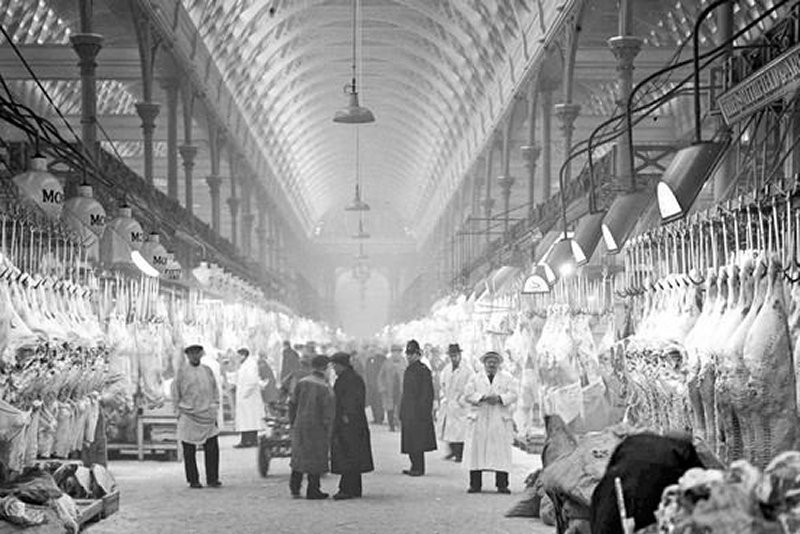
Smithfield Market
TUM image id:
1620388545
Licence:
St Lukes Hospital for Lunatics, London
TUM image id:
1554045418
Licence: CC BY 2.0
The gravestone of English poet William Blake in Bunhill Fields Burial Ground
Credit: https://careergappers.com/
TUM image id:
1622643378
Licence:
The Angel, Islington (c.1890)
TUM image id:
1557162442
Licence:
Saint John’s Gate, Clerkenwell, the main gateway to the Priory of Saint John of Jerusalem. The church was founded in the 12th century by Jordan de Briset, a Norman knight. Prior Docwra completed the gatehouse shown in this photograph in 1504. The gateway served as the main entry to the Priory, which was the center of the Order of St John of Jerusalem (the Knights Hospitallers).
Credit: Henry Dixon (1880)
TUM image id:
1557226611
Licence:
The Camden Head, Islington This is a glorious old gin palace-style pub behind Upper Street, in existence since the 18th century.
Credit: Flickr/Ewan Munro
TUM image id:
1622558868
Licence:
At the corner of Clerkenwell Road and Goswell Road sits the Hat and Feathers. It was built on the site of an earlier tavern around 1860 for owner James Leask. It was designed by William Finch Hill who specialised in music halls and pubs.
Credit: Ewan Munro
TUM image id:
1637770947
Licence:
View of Cloth Fair in 1884 showing the side entrance to St Bartholomew’s Priory, Smithfield.
Credit: John Crowther
TUM image id:
1622807402
Licence:
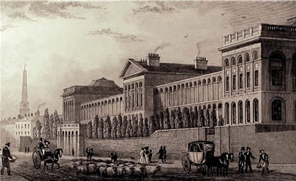
Holborn Viaduct from Farringdon Street, c. 1910 The building of Farringdon Street is considered one of the greatest urban engineering achievements of the 19th century. It was one of the first engineered multi-lane roads, and also buried the River Fleet in a system of underground tunnels, solving one of London’s most daunting sanitary problems. Its construction also included the building of the world’s first stretch of underground railway, a branch of the Metropolitan Railway that later became part of the London Underground running beneath Farringdon Road from King’s Cross St. Pancras into the City at Farringdon. The construction of Farringdon Street also necessitated the removal of the Fleet Market that had been built in 1736 above the course of the River Fleet, which is now London’s largest subterranean river. North of the market was Hockley-in-the-Hole (around Ray Street Bridge), an area notorious for bear-baiting and similar activities.
Credit: Bishopsgate Institute
TUM image id:
1686139066
Licence:
Florin Court, Charterhouse Square (2008) The building was used as Whitehaven Mansions, the fictional London residence of Agatha Christie’s character Hercule Poirot, in the LWT television series Agatha Christie’s Poirot (1989–2013)
Credit: Flickr/conrad1967/
TUM image id:
1682517671
Licence:
Great Arthur House, at the centre of the Golden Lane Estate, was the tallest residential building in Britain at the time of its construction.
Credit: Steve F/Wiki commons
TUM image id:
1582223961
Licence:
Islington Green (1905). Upper Street, leading to Highbury Corner. To the right of the green but just out of the picture would be Essex Road (formerly Lower Road)
Old London postcard
TUM image id:
1622547926
Licence:
Jewin Street looking east toward Red Cross Street (1920) Tubbs & Son sign outside premises and their posters in the window. It is probably Number 38, sometime home of the City of London Photographic Stores (1901) and Belprex Ltd (1927) The Fire Station at the end was built after the 1897 fire. Unsurprisingly the street name derives from an ancient Jewish burial ground. Jewin Street was widened after the 1897 fire.
TUM image id:
1671738816
Licence: CC BY 2.0
Pardon Street
Credit: The Underground Map
TUM image id:
1605906093
Licence:
Until combined in the twentieth century, St John Street was split between St John Street (south) and St John Street Road (north)
Old London postcard
TUM image id:
1620299776
Licence:
In the neighbourhood...
Click an image below for a better view...
St Lukes Hospital for Lunatics, London
Licence: CC BY 2.0
The gravestone of English poet William Blake in Bunhill Fields Burial Ground
Credit: https://careergappers.com/
Licence:
At the corner of Clerkenwell Road and Goswell Road sits the Hat and Feathers. It was built on the site of an earlier tavern around 1860 for owner James Leask. It was designed by William Finch Hill who specialised in music halls and pubs.
Credit: Ewan Munro
Licence:
Florin Court, Charterhouse Square (2008) The building was used as Whitehaven Mansions, the fictional London residence of Agatha Christie’s character Hercule Poirot, in the LWT television series Agatha Christie’s Poirot (1989–2013)
Credit: Flickr/conrad1967/
Licence:
Great Arthur House, at the centre of the Golden Lane Estate, was the tallest residential building in Britain at the time of its construction.
Credit: Steve F/Wiki commons
Licence:
Pardon Street
Credit: The Underground Map
Licence:
Kennedy’s - who sold sausages and pies around Camberwell and Peckham - delivering/receiving at Smithfield Market
Licence:
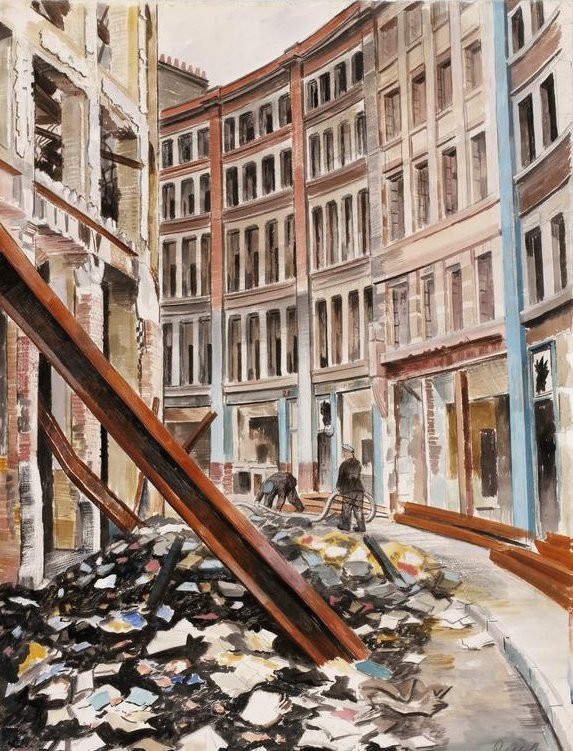
Jewin Crescent, London EC1 This 1940 drawing is by Roland Vivian Pitchforth - one of his works for the War Artists Advisory Committee and looks west along Jewin Crescent.
Credit: Roland Vivian Pitchforth/Imperial War Museum
Licence:
Royal Oak, Waterloo Street in the early 1960s. Waterloo Street once ran from Lever Street to Radnor Street. The original street dates from around 1829 and like other streets of similar name, commemorates Wellington’s 1815 victory. The whole area was redeveloped for the Pleydell Estate in 1965.
Credit: James Wyatt
Licence:
While Barbican is a London Underground station situated near the Barbican Estate, it has been known by various names since its opening in 1865, mostly in reference to the neighbouring ward of Aldersgate. The station was opened with the name Aldersgate Street on the Moorgate extension from Farringdon. It was built on the site of an earlier building at 134 Aldersgate Street, which for many years had a sign claiming "This was Shakespeare’s House". The station, which has no surface building, had its name shortened to Aldersgate on 1 November 1910 and was renamed again on 24 October 1924 as Aldersgate & Barbican. On 1 December 1968 the station’s name was simplified to Barbican. Train services were disrupted during the Second World War when the station suffered severe bomb damage in the Blitz. This led to the removal of the upper floors, and in 1955 the remainder of the street-level building was also demolished. The glass roof was replaced with awnings. This urged John Betjeman to write his poem ’Monody on the Death of Aldersgate Station’. Passenger trains from the Great Northern line, via the York Road and Hotel curves at King’s Cross to the Widened Lines, ran until the Great Northern’s electrification on 1976. The City Widened Lines were renamed the Moorgate line when overhead electrification was installed in 1982, allowing the Midland City Line service to run from Bedford via the Midland Main Line to Moorgate on the Thameslink service. The Thameslink platforms at Barbican were closed again in March 2009 as part of the Thameslink Programme to allow Farringdon to have its main line platforms extended across Thameslink’s Moorgate branch. Barbican now serves Underground lines only.
Credit: https://the-underground-map.myshopify.com/
Licence: