Hammersmith

Underground station, existing between 1864 and now.

 HOME  ·  ARTICLE  ·  MARKERS OFF  ·  STREETS  ·  BLOG  ·  CONTACT US 
(51.493 -0.224, 51.493 -0.224) 
MAP YEAR:175018001810182018301860190019502024 
Use the control in the top right of the map above to view this area on another historic map
 
Underground station · * · W6 ·
JUNE
18
2022
Hammersmith is a district in the London Borough of Hammersmith and Fulham, approximately eight kilometres west of Charing Cross on the north bank of the River Thames.

One of west London’s key transport hubs and commercial and employment centres, and home to several multinational company offices, Hammersmith is focused on the two London Underground stations, a bus station and as an important road network node.

Hammersmith’s pedestrianised riverside is popular for its many pubs, its excellent views of the river and the annual Oxford-Cambridge Boat Race which passes by.

The area has provided a location for several TV programmes - for instance, The Flying Squad were Hammersmith-based in the 1970s TV series The Sweeney.

Hammersmith is served by two tube stations, one is the western terminus of the Hammersmith & City Line, the other by the Piccadilly and District Lines. Both are called Hammersmith. The latter tube station is part of a larger office, retail and transport development, locally known as The Broadway after its large encompassing roundabout.

The present Hammersmith & City station is situated on Beadon Road and opened on 1 December 1868, replacing the original station slightly north of here which opened on 13 June 1864 when the line extension was built from Paddington. The Circle line has served Hammersmith since 13 December 2009.

The Piccadilly and District line station was opened on 9 September 1874 by the Metropolitan District Railway (now the District Line) as the western terminus of the railway when it was extended from Earl’s Court.


..

Main source: Wikipedia
Further citations and sources


Click here to explore another London street
We now have 670 completed street histories and 46830 partial histories
Find streets or residential blocks within the M25 by clicking STREETS

...

CONTRIBUTIONS TO THE LOCALITY

None so far :(
LATEST LONDON-WIDE CONTRIBUTIONS TO THE PROJECT

Born here
Roy Mathieson   
Added: 27 Jun 2024 16:25 GMT   

St Saviours
My great grandmother was born in Bowling Green Lane in 1848. The family moved from there to Earl Terrace, Bermondsey in 1849. I have never been able to locate Earl Terrace on maps.

Reply

   
Added: 26 Jun 2024 13:10 GMT   

Buckhurst Street, E1
Mt grandfather, Thomas Walton Ward had a musical instrument workshop in Buckhurst Street from 1934 until the street was bombed during the war. Grandfather was a partner in the musical instrument firm of R.J. Ward and Sons of Liverpool. He died in 1945 and is buried in a common grave at Abney Park Cemetery.

Reply
Lived here
Mike Dowling   
Added: 15 Jun 2024 15:51 GMT   

Family ties (1936 - 1963)
The Dowling family lived at number 13 Undercliffe Road for
Nearly 26 years. Next door was the Harris family

Reply
Comment
Evie Helen   
Added: 13 Jun 2024 00:03 GMT   

Vickers Road
The road ’Vickers Road’ is numbered rather differently to other roads in the area as it was originally built as housing for the "Vickers" arms factory in the late 1800’s and early 1900s. Most of the houses still retain the original 19th century tiling and drainage outside of the front doors.

Reply

Paul Harris    
Added: 12 Jun 2024 12:54 GMT   

Ellen Place, E1
My mother’s father and his family lived at 31 Ellen Place London E1 have a copy of the 1911 census showing this

Reply
Comment
   
Added: 10 Jun 2024 19:31 GMT   

Toll gate Close
Did anyone live at Toll Gate Close, which was built in the area where the baths had been?

Reply

Charles Black   
Added: 24 May 2024 12:54 GMT   

Middle Row, W10
Middle Row was notable for its bus garage, home of the number 7.

Reply
Comment
   
Added: 2 May 2024 16:14 GMT   

Farm Place, W8
The previous name of Farm Place was Ernest St (no A)

Reply


NEARBY LOCATIONS OF NOTE
Hammersmith Hammersmith is a district in the London Borough of Hammersmith and Fulham, approximately eight kilometres west of Charing Cross on the north bank of the River Thames.
Hammersmith to Goldhawk Road walk This is a proposed walk between Hammersmith and Goldhawk Road along the Hammersmith & City Line.
Lyric Hammersmith The Lyric Theatre (Lyric Hammersmith) is a theatre off King Street, Hammersmith.
Sacred Heart High School Sacred Heart High School is a Roman Catholic girls secondary school in Hammersmith.
St Paul’s Girls’ School St Paul’s Girls’ School is an independent school which accepts students between the ages of 10 and 19.

NEARBY STREETS
Adie Road, W6 Adie Road leads west from Hammersmith Grove (Hammersmith)
Agate Road, W6 Agate Road is a street in Hammersmith (Hammersmith)
Aiten Place, W6 Aiten Place is a road in the W6 postcode area (Hammersmith)
Albion Court, W6 Albion Court is a street in Hammersmith (Hammersmith)
Albion Mews, W6 Albion Mews is a street in Hammersmith (Hammersmith)
Albion Place, W6 Albion Place is a street in Hammersmith (Hammersmith)
Aldensley Road, W6 Aldensley Road is a street in Hammersmith (Hammersmith)
Amor Road, W6 Amor Road is a road in the W6 postcode area (Hammersmith)
Angel Walk, W6 Angel Walk was previously Angel Road before 1938 (Hammersmith)
Argyle Place, W6 Argyle Place is a street in Hammersmith (Hammersmith)
Ashcroft Square, W6 Ashcroft Square is a street in Hammersmith (Hammersmith)
Aspen Gardens, W6 Aspen Gardens serves the blocks of the Aspen Gardens Estate (Hammersmith)
Aspen Place, W6 In a complicated set of renamings, both Providence Yard and Henrietta Place became Aspen Place in 1891 (Hammersmith)
Aynhoe Road, W14 Aynhoe Road is a street in West Kensington
Banim Street, W6 Banim Street is a street in Hammersmith (Hammersmith)
Barb Mews, W6 Barb Mews is a through road off Shepherds Bush Road
Batoum Gardens, W6 Batoum Gardens is a street in Hammersmith
Beadon Road, W6 Beadon Road runs down to the Hammersmith and City Line station in central Hameersmith (Hammersmith)
Beauclerc Road, W6 This is a street in the W6 postcode area (Hammersmith)
Beavor Lane, W6 Beavor Lane is a street in Hammersmith (Hammersmith)
Benbow Court, W6 Benbow Court is a block on Benbow Road (Hammersmith)
Benbow Road, W6 Benbow Road is a street in Hammersmith (Hammersmith)
Berestede Road, W4 Berestede Road is a road in the W6 postcode area (Hammersmith)
Biscay Road, W6 Biscay Road is in Fulham (Fulham)
Black Lion Lane, W6 Black Lion Lane is a street in Hammersmith (Hammersmith)
Black Lion Mews, W6 Black Lion Mews is a road in the W6 postcode area (Hammersmith)
Black’s Road, W6 This is a street in the W6 postcode area (Hammersmith)
Blades Court, W6 Blades Court is a street in Hammersmith (Hammersmith)
Brackenbury Gardens, W6 Brackenbury Gardens may date from the 1870s (Hammersmith)
Brackenbury Road, W6 Brackenbury Road is a street in Hammersmith (Hammersmith)
Bridge Avenue, W6 Bridge Avenue is a street in Hammersmith (Hammersmith)
Bridge View, W6 Bridge View is a street in Hammersmith (Hammersmith)
British Grove South, W4 British Grove South is a road in the W4 postcode area (Hammersmith)
British Grove, W6 The Hammersmith and Turnham Green British School created the name British Grove. (Hammersmith)
Broadway Chambers, W6 Broadway Chambers is a street in Hammersmith (Hammersmith)
Broadway Shopping Centre, W6 Broadway Shopping Centre is a street in Hammersmith (Hammersmith)
Brook Green, W14 Brook Green runs either side of the green of the same name - the W14 section runs north of the green
Brook Green, W6 Brook Green runs both side of the green of the same name
Brook House, W6 Brook House is a block on Shepherds Bush Road (Hammersmith)
Bute Gardens, W6 Bute Gardens is a street in Hammersmith (Hammersmith)
Butterwick, W6 Butterwick is part of the one-way system around Hammersmith station (Hammersmith)
Caithness Road, W14 Caithness Road is a street in West Kensington
Cambridge Court, W6 Cambridge Court is a street in Hammersmith (Hammersmith)
Cambridge Grove, W6 Cambridge Grove was previously called Cambridge Road (Hammersmith)
Cambridge House, W6 Residential block (Hammersmith)
Cardross Street, W6 Cardross Street is a road in the W6 postcode area (Hammersmith)
Carnegie House, W6 Carnegie House is a block on Shepherds Bush Road (Hammersmith)
Caroline House, W6 Caroline House is a block on Crisp Road (Hammersmith)
Carthew Road, W6 Carthew Road was originally part of Bradford Fords (Hammersmith)
Carthew Villas, W6 Carthew Villas is a road in the W6 postcode area (Hammersmith)
Chalk Hill Road, W6 Chalk Hill Road is a road in the W6 postcode area
Chambon Place, W6 Chambon Place is a road in the W6 postcode area (Hammersmith)
Chancellor’s Road, W6 This is a street in the W6 postcode area (Hammersmith)
Chancellors Street, W6 Chancellors Street is a street in Hammersmith (Hammersmith)
Chancellors Wharf, W6 Chancellors Wharf is a street in Hammersmith (Hammersmith)
Charlotte House, W6 Charlotte House is one of a number of local blocks named after female members of the British Royal Family (Hammersmith)
Colet Gardens, W14 Colet Gardens is a shadow of its former self
Coulter Road, W6 Coulter Road is a road in the W6 postcode area (Hammersmith)
Crisp Road, W6 Crisp Road is a street in Hammersmith (Hammersmith)
Crisp Walk, W6 Crisp Walk is a location in London (Hammersmith)
Cromwell Avenue, W6 Cromwell Avenue is a street in Hammersmith (Hammersmith)
Cromwell Grove, W6 Cromwell Grove is a street in Hammersmith
Dimes Place, W6 Dimes Place is a street in Hammersmith (Hammersmith)
Down Place, W6 Down Place is a street in Hammersmith (Hammersmith)
Elms House, W6 Elms House is a building on Brook Green
Eyot Gardens, W4 Eyot Gardens is a street in Hammersmith (Hammersmith)
Felgate Mews, W6 Felgate Mews is a street in Hammersmith (Hammersmith)
Fulham Palace Road, W6 Fulham Palace Road is a street in Hammersmith (Hammersmith)
Galena Road, W6 Galena Road is a street in Hammersmith (Hammersmith)
Girdlers Road, W14 Girdlers Road is a road in the W14 postcode area
Glenthorne Mews, W6 Glenthorne Mews is a street in Hammersmith (Hammersmith)
Glenthorne Road, W6 Glenthorne Road is a major thoroughfare in Hammersmith (Hammersmith)
Great Church Lane, W6 Great Church Lane is a street in Hammersmith (Barons Court)
Great West Road, W6 Great West Road is a street in Hammersmith (Hammersmith)
Griffin House, W6 Griffin House is a block on Hammersmith Road
Grove Mews, W6 Grove Mews runs parallel with Hammersmith Grove (Hammersmith)
Grove Passage, W4 British Grove Passage is a road in Chiswick (Hammersmith)
Haarlem Road, W14 Haarlem Road runs from Dunsany Road to Augustine Road in West Kensington, (Hammersmith)
Hammersmith Bridge Road, W6 Hammersmith Bridge Road is a street in Hammersmith (Hammersmith)
Hammersmith Broadway, W6 Hammersmith Broadway is a major transport node and also the name of a shopping centre (Hammersmith)
Hammersmith Flyover, W6 The Hammersmith flyover is an elevated roadway which carries the A4 arterial road over the central Hammersmith gyratory system (Hammersmith)
Hammersmith Grove, W6 Hammersmith Grove is a street in Hammersmith (Hammersmith)
Hammersmith Road, W6 Hammersmith Road is a street in Hammersmith (Hammersmith)
Hammersmith Terrace, W6 Hammersmith Terrace is a street in Hammersmith (Hammersmith)
Hebron Road, W6 Hebron Road is a road in the W6 postcode area (Hammersmith)
Holcombe Street, W6 Holcombe Street is a street in Hammersmith (Hammersmith)
Iffley Road, W6 Iffley Road is a street in Hammersmith (Hammersmith)
Inca House, W6 Inca House is a block on Shepherds Bush Road
Kilmarsh Road, W6 Kilmarsh Road is a street in Hammersmith (Hammersmith)
King Street Cloisters, W6 King Street Cloisters is a street in Hammersmith (Hammersmith)
King Street, W6 King Street is a street in Hammersmith (Hammersmith)
Kings House, W6 Kings House is sited on Hammersmith Road
Kings Mall, W6 Kings Mall is a street in Hammersmith (Hammersmith)
Lamington Street, W6 Lamington Street is a street in Hammersmith (Hammersmith)
Latymer Court, W6 Latymer Court, when opened, was the largest block of flats of its type in the country
Lena Gardens, W6 Lena Gardens is a street in Hammersmith
Linacre Court, W6 Linacre Court is a block on Unnamed Road (Barons Court)
Linden House, W6 Linden House is a block on Upper Mall (Hammersmith)
Lord Napier Place, W6 Lord Napier Place is a street in Hammersmith (Hammersmith)
Loris Road, W6 Loris Road is a road in the W6 postcode area
Lower Mall, W6 Lower Mall is a street in Hammersmith (Hammersmith)
Luxemburg Gardens, W6 Luxemburg Gardens is a street in Hammersmith (Hammersmith)
Lyric Square, W6 This is a street in the W6 postcode area (Hammersmith)
Macbeth Street, W6 Macbeth Street is a street in Hammersmith (Hammersmith)
Mall Road, W6 Mall Road is a street in Hammersmith (Hammersmith)
Margravine Gardens, W6 Margravine Gardens runs west from Barons Court station (Barons Court)
Melrose Gardens, W6 Melrose Gardens is a road in the W6 postcode area
Mercers Place, W6 Mercers Place is a road in the W6 postcode area
Metro Building, W6 Metro Building is sited on Chalk Hill Road (Hammersmith)
Metropolitan Station Arcade, W6 Metropolitan Station Arcade is a row of shops connected to the Hammersmith & City/Circle Line station in Hammersmith (Hammersmith)
Mulberry Place, W6 Mulberry Place is a road in the W6 postcode area (Hammersmith)
North Verbena Gardens, W6 North Verbena Gardens is a road in the W6 postcode area (Hammersmith)
Oil Mill Lane, W6 Oil Mill Lane is a street in Hammersmith (Hammersmith)
Overlord House, W14 Overlord House can be found on Colet Gardens
Overstone Road, W6 Overstone Road is a street in Hammersmith (Hammersmith)
Oxford Gate, W14 Oxford Gate is a road in the W14 postcode area
Poplar Grove, W6 Poplar Grove is a street in Hammersmith
Queen Caroline Street, W6 Caroline of Brunswick, wife of George IV, lived and died in nearby Brandenburg House (Hammersmith)
Ravenscourt Avenue, W6 Ravenscourt Avenue is a street in Hammersmith (Hammersmith)
Ravenscourt Place, W6 Ravenscourt Place runs behind Ravenscourt Park station (Hammersmith)
Redmore Road, W6 Redmore Road is a street in Hammersmith (Hammersmith)
Richford Gate, W6 Richford Gate is a street in Hammersmith
Richford Street, W6 Richford Street is a street in Hammersmith (Hammersmith)
Rivercourt Road, W6 Rivercourt Road is a road in the W6 postcode area (Hammersmith)
Riverside Gardens, W6 Riverside Gardens is a street in Hammersmith (Hammersmith)
Rowan Road, W6 Rowan Road is a street in Hammersmith
rr, W6 Glemthorne Mews is a street in Hammersmith (Hammersmith)
Rutland Grove, W6 Rutland Grove is a road in the W6 postcode area (Hammersmith)
Shepherds Bush Road, W6 Shepherds Bush Road is the main road connecting Shepherds Bush and Hammersmith
Ship Lane, W6 Ship Lane was formerly known as Bridge Street (Hammersmith)
Shortlands, W6 Shortlands commemorates a local field name, first mentioned in the reign of Henry V
Souldern Road, W14 Souldern Road is a street in West Kensington
South Black Lion Lane, W6 South Black Lion Lane is a street in Hammersmith (Hammersmith)
Southerton Road, W6 Southerton Road is a street in Hammersmith (Hammersmith)
St Peter’s Wharf, W6 St Peter’s Wharf is a road in the W6 postcode area (Hammersmith)
St Peters Road, W6 St Peters Road is a street in Hammersmith (Hammersmith)
St Peter’s Grove, W6 Saint Peter’s Grove runs south off of King Street (Hammersmith)
St Peter’s Square, W6 St Peter’s Square is a garden square laid out in the 1820s (Hammersmith)
St. James Street, W6 St. James Street is a road in the W6 postcode area (Hammersmith)
Studland Street, W6 Studland Street is a street in Hammersmith (Hammersmith)
Sulgrave Road, W6 Sulgrave Road is a street in Hammersmith
Sussex Place, W6 Sussex Place is a road in the W6 postcode area (Hammersmith)
Sycamore Gardens, W6 Sycamore Gardens is a street in Hammersmith (Hammersmith)
Tabor Road, W6 Tabor Road is a street in Hammersmith (Hammersmith)
The Arches, W6 The Arches is a street in Hammersmith (Hammersmith)
The School House, W6 The School House is a block on Brook Green
The Square, W6 The Square is a road in the W6 postcode area (Hammersmith)
Theresa Road, W6 Theresa Road is a street in Hammersmith (Hammersmith)
Trafalgar Street, W6 Trafalgar Street was a small street in Hammersmith, off Aspen Place (Hammersmith)
Trussley Road, W6 Trussley Road connects areas either side of the Hammersmith and City line (Hammersmith)
Upper Mall, W6 Upper Mall is a street in Hammersmith (Hammersmith)
Vencourt Place, W6 Vencourt Place is a street in Hammersmith (Hammersmith)
Vinery Way, W6 Vinery Way is a road in the W6 postcode area (Hammersmith)
Waterhouse Close, W6 Waterhouse Close is a street in Hammersmith (Barons Court)
Wellington Walk, W6 Wellington Walk was a former street of Hammersmith (Hammersmith)
Weltje Road, W6 Weltje Road was named for the Prince Regent’s chef (Hammersmith)
Western Terrace, W6 Western Terrace is a street in Hammersmith (Hammersmith)
Wolverton Gardens, W6 Wolverton Gardens is a street in Hammersmith (Hammersmith)
Worlidge Street, W6 Worlidge Street is a street in Hammersmith (Hammersmith)
Yeldham Road, W6 Yeldham Road is a location in Fulham (Fulham)
York House, W6 A street within the W6 postcode (Hammersmith)

NEARBY PUBS
Black Lion The Black Lion is situated on the north bank of the River Thames between Hammersmith and Chiswick.
Blue Anchor The Blue Anchor is an iconic pub on the banks of the river Thames at Hammersmith.
Duke of Edinburgh The Duke of Edinburgh was located at 52 Queen Caroline Street, Hammersmith.
Queen’s Head The Queens Head is a pub on Brook Green.
Royal Sussex Arms The Royal Sussex Arms stood at 26 Hammersmith Broadway.
Six Bells The Six Bells was open between 1826 and about 1959.
Stonemasons Arms, W6 The Stonemasons Arms lies on the corner of Glenthorne Road and Cambridge Grove.
The Cannon The Cannon was situated at 80 Queen Caroline Street, Hammersmith.
The Distillers Arms The Distillers Arms marks the boundary between Hammersmith and Fulham.
The Rutland Arms The Rutland Arms lies along the River Thames at Hammersmith.


Click here to explore another London street
We now have 670 completed street histories and 46830 partial histories


LOCAL PHOTOS
Click here to see map view of nearby Creative Commons images
Click here to see Creative Commons images near to this postcode
Shepherd's Bush Road, W6
TUM image id: 1488542121
Licence: CC BY 2.0
Colet House
Credit: The Study Society
TUM image id: 1605092347
Licence: CC BY 2.0

In the neighbourhood...

Click an image below for a better view...
Sacred Heart High School, Hammersmith (2013)
Credit: Wiki Commons/Chmee2
Licence: CC BY 2.0


Stage hands at the Lyric Opera House, Hammersmith (1897) Later called the Lyric Theatre, it had been redesigned in 1895 and opened by Lille Langtry
Licence: CC BY 2.0


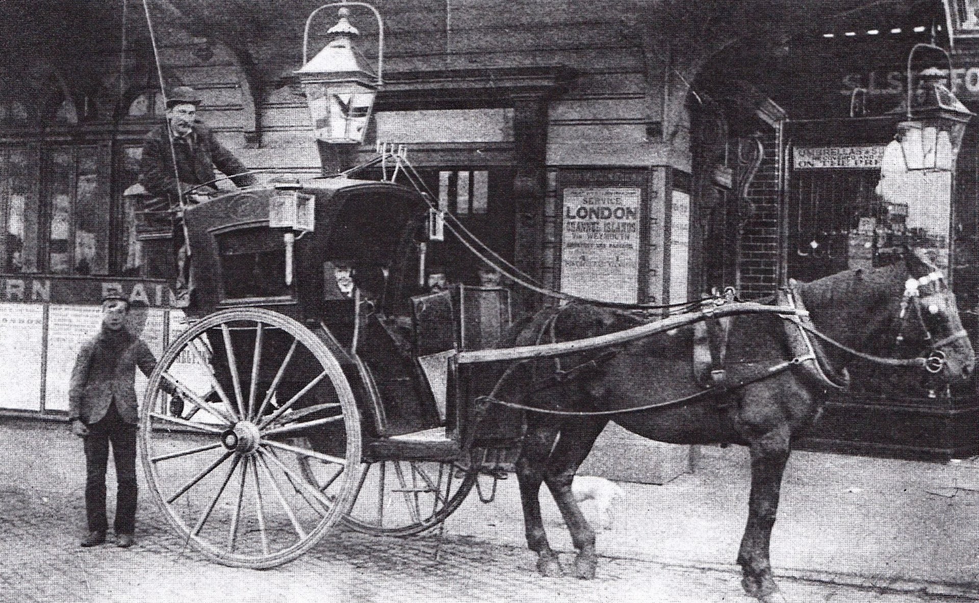
Horse-drawn cab outside Hammersmith station in Beadon Road (1894) Staffords - the shop next to the station - repaired and sola umbrellas.
Licence:


Cambridge Road (now Cambridge Grove) during the Edwardian period. A District Line train is crossing the bridge.
Licence:


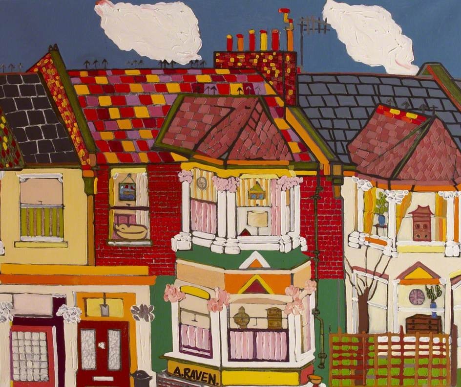
Dewhurst Road, Hammersmith
Credit: Adam Raven (1952–2006), Hammersmith Library
Licence:


Margaret House - an original section of the Caroline Estate built in the early twentieth-century. The London County Council extended the estate in 1953. In the background, you can see a tall red-brick building with prominent chimneys. This was another housing estate, which was owned and run by the Peabody Trust. Previously, the site had been home to the Convent of the Good Shepherd, which closed in 1920.
Credit: London Metropolitan Archives
Licence: CC BY 2.0


Glenthorne Road looking east towards St John’s Church (1901)
Licence: CC BY 2.0


10-16 Grove Mews, c. 1906 Finch & Son occupied 10-11 for several years and expanded to no.9 from 1912.
Licence:


Extension of the Piccadilly Line station in Hammersmith Broadway (1930) London Underground proudly announce that the works will relieve unemployment. Beatrice Lillie and Nellie Wallace are billed at the Coliseum in the West End.
Licence:


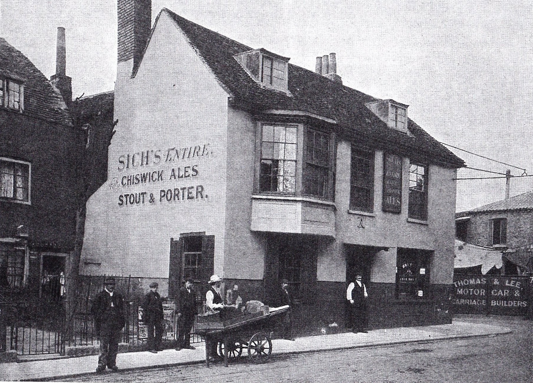
Charlotte House, Hammersmith stands on the location of The Cannon pub, pictured here in 1900
Licence: CC BY 2.0


  Contact us · Copyright policy · Privacy policy