Adela Street is a small cul-de-sac in Kensal Town.
Thanks to a feature about the movie Steptoe and Son (1972) on the
ReelStreets website, we are taking a small trip both down memory lane and indeed Adela Street in Kensal Town.
Adela Street is a tiny, otherwise inconsequential cul-de-sac off of Kensal Road. It might have remained that way had not location scouts discovered it had, in the early 1970s, just the right look as the location of Oildrum Lane "in Shepherd's Bush", the site of the Steptoe's fictional scrapyard.

"Oildrum Lane, Shepherds Bush" (click image to enlarge)
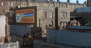
Let's first join that cantankerous duo as they amble into Oildrum Lane. In a gripping piece of plot, the father and son have just been to visit the Royal Courts of Justice where their horse and cart received a parking ticket.
For those who know this street, the camera is situated on the west side of Adela Street. To the left of the Vernons billboard lies "The Cut" - the Grand Union Canal, though you can't see it here. Those larger buildings are on Harrow Road but they have since been demolished.

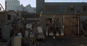
As the horse and cart enters the yard, the camera position changes to face 'Arold and the main memory of many a West Tenner, the gasworks at the top of Ladbrove Grove comes into view.
Adela Road was always a bit of a nondescript piece of real estate but the Steptoes seem to make it look particularly terrible! Adela Street was originally built by Mr Richard Ward of Holland Park in 1871. The name may be connected with Adela Ward Richardson, a spinster lady who owned several properties in North London in the mid-nineteenth century and was probably related to Richard Ward.
Adela Street had a brief starring role in the seminal 1972 movie Steptoe and Son as it doubled up as the location of Oildrum Lane, the site of their scrapyard.
As depicted in the film, Adela Street looks run down, but since the 1970s it has undergone a bit of a transformation. It is now the site of some expensive real estate.
The property booms which came later changed Adela Street into a desirable address.

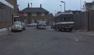
Looking towards Kensal Road (click image to enlarge)
In a very 1972 looking shot, we briefly glimpse Adela Street looking the other way, back towards Kensal Road. In a modern shot, the building opposite the end of the street remains, but the buildings on both sides of the street have been upgraded,
In the days before we all had smartphones and were able to take photos of everything, the films and TV programmes of the 1950s, 1960s and 1970s are sometimes the only public record of the look and the streets of London in those post-war years.
London W10 was rather well-documented via the medium of cinema - "The Blue Lamp" for the 1950s up tp "Minder" in the 1980s via the likes of "The Sweeny" means that we have a record of the area, bombsites all all. Certain of us are not watching the film at all, but the background scenes.
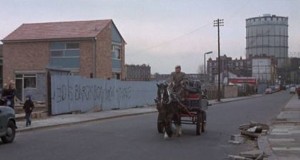
One last still from Steptoe and Son shows not Adela Street but instead Southern Row. One last view of our old friend, the gasholder.

This website does not sell maps. Instead it offers a subscription service via Substack using which you can download unlimited maps.
Find out how to use the service by clicking ABOUT above and finding the section which says How to use the mapping service. |


